Archive for December, 2012
I have been wanting to go see the Steels Creek Falls or, as my friend Dave calls them, the ‘Pothole Falls’ for quite sometime now and we finally got around to going on Wed. December 19, 2012. This would probably be the last chance of the year before the gate is closed and winter weather makes it harder if not impossible to get to the falls so we decided that this would be our destination for this hike. It was a cold and frosty morning when we left Hairnt-Quarters around 10am and drove the hour and a half over to the North Carolina mountains and found the forest road #228 open to Steels Creek so, we drove to the end of the road where the trail head is that leads up Steels Creek. As you will see during the drive on the gravel forest road, the Steels Creek Valley lies just below and on the backside of the towering Jonas Ridge where Sitting Bear, Hawksbill, and Tablerock Mountains which are above the Linville Gorge are located. The Mountains To Sea Trail which also goes over Tablerock Mountain is also located along part of the Steels Creek as well and actually goes right beside the falls we were going to see. We had not hiked very far away from the trail head when we met a young couple already on their way back who wished us ‘good luck’ !. I had to assume they were unsuccessful in reaching the falls and within minutes we came to a creek crossing that explained where they most likely had difficulty and decided to turn around. After all, not all trails to waterfalls are easy.
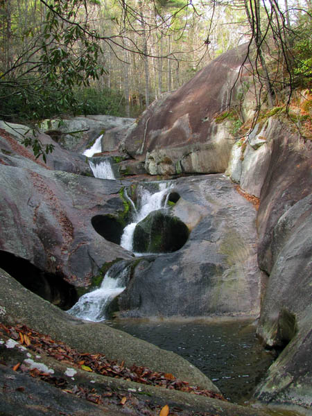
Steels Creek Falls
(more…)
Posted on 27 December '12 by RAT, under RATtreks. No Comments.
Ever since my friend Bol’Dar discovered the hidden waterfalls that we named ‘Wilderness Falls‘ we have been trying to get an accurate measurement of their approximate height but, due to the extremely steep terrain and growth around these falls, it has been a difficult task. We decided to make a trip there now that the leaves are all down and there is very little water flowing to see if we could get the numbers we needed. To do this we recruited the help of Dave Aldridge, our waterfall loving friend who has a laser hypsometer that he uses to get some very accurate readings on waterfall heights. It was a chilly but sunny morning when Dave, Bol’Dar and myself met at Hairnt-Quarters around 9:30am. It is a short drive to Clarks Creek from there so after stopping for coffee we were on the trail by 10am. The road is blocked at this time with the construction of a new bridge over Longarm Branch but, since we were actually going up the Longarm Branch Trail this was not much of a detour. We just had to negotiate around the new bridge by going up Clarks Creek as the bridge is located where the two creeks come together.
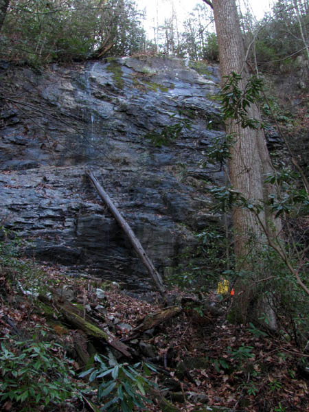
Bol’Dar standing at the base of the Middle Wilderness Falls
(more…)
Posted on 25 December '12 by RAT, under RATtreks. No Comments.
It was a rainy Tuesday in November not fit for any long trips to the mountains so, my waterfall loving friend Dave and I decided to go check out some places for a short hike and maybe get to see some waterfalls. We ended up in the Bays Mountain area near the Holston River where Dave knew about some falls he got to name ‘Big Logger and Little Logger Falls‘ named after the man who owns the property where the falls are located that just happens to be in the log business. We went there and spoke with that man but it was raining a bit too hard at that time so we decided to drive around to locate some other falls we had heard about in the Kiner Creek area. On the way we passed by the Bays Mountain Falls where I took some pictures from the road high above them. I will go back later when there is more water to get better shots from below them. We found Laurel Run Park where the creek comes out and parked there and started walking up the well maintained trail into the Laurel Run Hollow. It was still drizzling rain. The first thing we came to was a small waterfall that to my knowledge has no name. It is not very high but a nice falls with a large pool to say the least. We did not stop to take any pictures then but saved that for on the way back. We continued up the hollow and soon came to the Laurel Run Falls. These are only about 12 feet in height but are a very pleasant looking falls even in low water like it was on this trip.

Laurel Run Falls
(more…)
Posted on 24 December '12 by RAT, under RATtreks. No Comments.
Every Fall I try to go up to Viking Mountain to see the leaves when they are in peak color and the incredible views from Whiterock and Blackstack Cliffs. This year was no exception. Although the leaves were already past peak it was still colorful enough to make it worth the trip. Linda and I got to the top of the mountain around early afternoon and took the blue-blaze trail down to the Appalachian Trail and hiked North until we could soon see the Whiterock Cliffs off in the distance. These magnificent rock formations are located in and lookout over the North Carolina side of the mountain. There is a short side trail that leads out to the top of the cliffs. There is a sign marking the turnoff. It was a very bright, sunny day without any clouds which worked against getting any good photo`s but, it was still a beautiful site and a great day to be on the mountain. Linda had never been there so it was a treat for her as well.
View from Whiterock Cliffs
(more…)
Posted on 20 December '12 by RAT, under RATtreks. No Comments.
After our recent trip to the Grandfather Mountain area along the Blue Ridge Parkway the week prior, we decided to come back and go to the Grandfather Mountain Park in hopes that the leaves would be more in peak colors. Linda had never been to the park and I had not been there since I was a kid around 1966 or 1967. We tried to get there as early as possible to beat the crowds but it was around 1:30pm before we could make it so, they were beginning to line up at the entrance gate already however, it did not take but a few minutes to pay and get through the gate. They give you a CD to play on your way up the mountain road which describes all the details and history of what you are seeing along the way. We stopped at the first overlook on the left to get a view of what the leaf colors were like before making our way further up the winding mountain road.
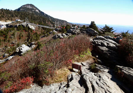
Mile High Swinging Bridge on Grandfather Mountain
(more…)
Posted on 17 December '12 by RAT, under RATtreks. No Comments.
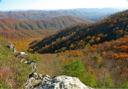
The Fall colors came later in the season than usual this year and in my opinion were not as vivid as years prior except in spots. Since the colors begin in the higher elevations first and were not even beginning to turn in the lower valleys, we had heard on the local news that they were in peak in the high country of North Carolina. This prompted my girlfriend Linda and I to take a trip to the Blue Ridge Parkway to check it out for ourselves.

Linn Cove Viaduct along the Blue Ridge Parkway
(more…)
Posted on 12 December '12 by RAT, under RATtreks. 1 Comment.


 My name is 'RAT' and I love the mountains and waterfalls of the East TN. area where I live and I hope you enjoy this blog about my outdoor adventures.


