Archive for November, 2010
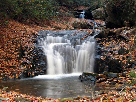
Indian Summer is still hanging in there with sunny days and warm temps, so this past Saturday found my son Tyler, my friend Bol’Dar, and myself back in the Rocky Fork area. The creek had even more water flowing than our previous trip, although it had not rained much, but our destination was located off what we call the ‘high road‘ and then to the curve in the road where the Long Branch creek and trail enters. This is a little over half a mile from the gate. There are remnants of an old log road that leads into this hollow but some parts are overgrown and rough going where other parts are passable.
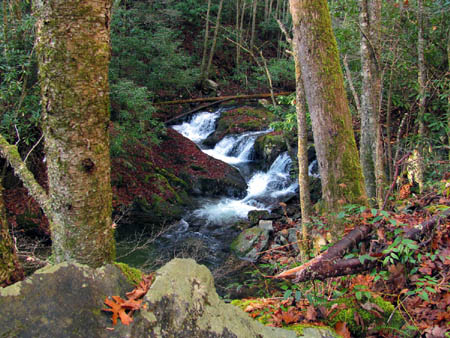
Cascades along Rocky Fork Creek
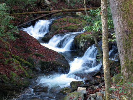
Cascades along Rocky Fork Creek
(more…)
Posted on 19 November '10 by RAT, under RATtreks. 2 Comments.
I recently had the good fortune of going on another hiking adventure with my friend Dave Aldridge. He is an avid fellow ‘waterfaller’ and has been trying to find the elusive Sulphur Spring Branch Falls that are located on the South Holston Lake side of Holston Mountain in Sullivan County. There is not much information available about these falls and even the TN Landforms website had a question mark beside them and the GPS location they list is inaccurate,,,,until now ! Many have tried to find these falls and failed. The only photo I have found is the one on the TN Landforms site by William Stowell but, there are no directions and the GPS waypoint was incorrect. On Dave’s first attempt, he was out on a scouting mission and, the weather turned bad so he had to get off the mountain. The route he was taking (using the only information and GPS available) was not a very good way to go, and further research led him to believe that there was an easier way from an old forest service road and horse trail located closer to where the falls were supposed to be. Armed with that information, some maps, and a positive attitude,we set out to find these waterfalls.
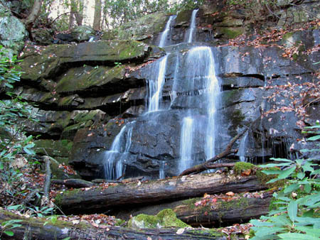
Sulpur Spring Branch Falls (upper)
(more…)
Posted on 14 November '10 by RAT, under RATtreks. No Comments.
I recently went on a day hike with my new friend Dave Aldridge to the Upper Sill Branch Falls which are located in Clarks Creek inside the Sampson Mountain Wilderness area. Although there is not much water flowing right now, it was still a great day to be in the woods and any day in the Sill Branch area is a good day. Due to the cold morning temps we waited until 10 a.m. before heading out. The sun was up and it was a beautiful day. Even though many of the colors have already gone and bunches of leaves are already on the ground, there is still so much beauty to see. To me, even the faded colors are awesome especially when they are in contrast to the evergreen trees and blue sky around them.
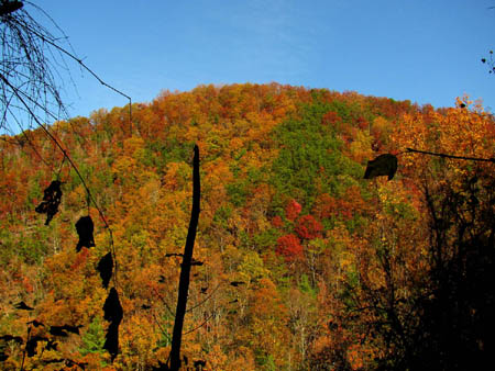
Meatgrinder Ridge showing Fall colors
(more…)
Posted on 3 November '10 by RAT, under RATtreks. No Comments.
It has been several months since I have been on what I consider a truly awesome adventure (Buckeye Falls in March of 2010 comes to mind) but, this past week has fulfilled that quest. I had been out taking pics of the Fall colors the weekend before and ended up in the Devil Fork area looking for the waterfalls there. Not to be confused with the Devil’s Fork Falls in the Sampson Mtn. Wilderness area, but the one on SR 352 that leads to Devil Fork Gap where the Appalachian Trail crosses. I had found several awesome cascades that weekend but fell just short of the actual Devil Fork Falls. This prompted me to come back there as soon as possible, so on 10-19-2010, my friend Bol’Dar and myself did just that. After our usual late morning start of around 10 a.m., we arrived on Devil Fork Road (SR 352) about 11 a.m. or so. Parking at the water supply access road, (about 1500 feet from the beginning of the road) we then walked farther up the paved road about 500 feet or so to where you can see the falls below the left side of the highway. This is where I left off last time beside the hornets nest, so we went down the bank there which leads right to the falls.
Devil Fork Falls (lower)

Devil Fork Falls (upper)
(more…)
Posted on 1 November '10 by RAT, under RATtreks. No Comments.


 My name is 'RAT' and I love the mountains and waterfalls of the East TN. area where I live and I hope you enjoy this blog about my outdoor adventures.


