


Big Lost Cove Cliffs – 7-16-2012
Ever since our trip to the Little Lost Cove Cliffs on 6-13-2012, I have been wanting to see the Big Lost Cove Cliffs. This is because as awesome as the little ones are the big ones must be much better right ? On 7-16-2012 I would get my answer. My friend Dave and I arrived at the trail head at our usual time of 10:30am after the hour and half drive over the mountain to North Carolina. It was a partly sunny and hot day with chances of thunderstorms so it was looking like we would have some clouds that would help make the pictures turn out better although we did not want to get caught in any storms while out on the exposed rocks.
Dave on the Big Lost Cove Cliffs
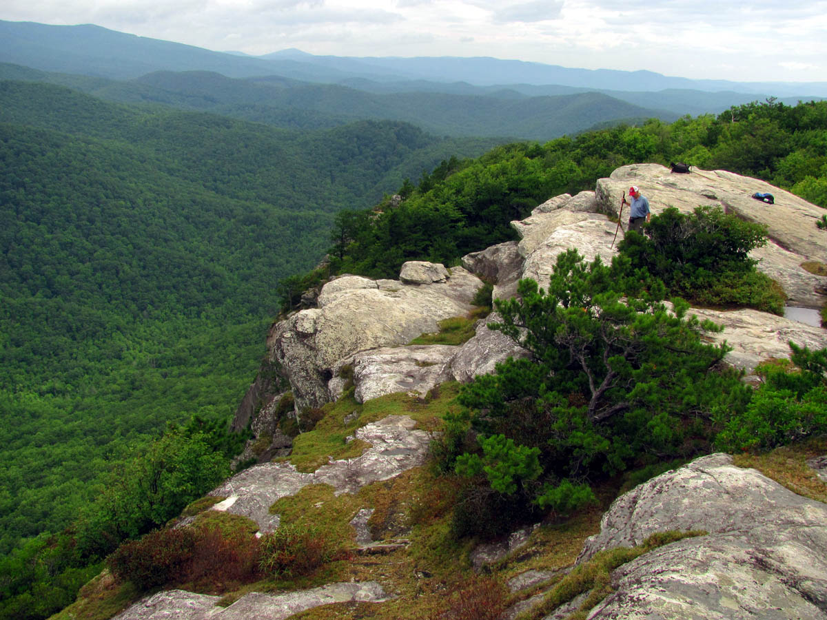
Taking trail # 271, which is a nice yellow blazed trail , it was not long before we were on the top of the ridge and hiking in the direction of the cliffs. After about a mile or so we actually started going downhill and then started seeing some sizable rocks along the way. The laurels were still blooming so the sights and smells of the woods was very pleasing. After about a mile and half we came to the first rock cliff on the left. This was impressively high and although the camera can not capture the actual height very well, you can take my word that the trees growing up beside them are at least 50 to 60 feet tall ! Looking down from the top does give you that uneasy feeling !We found a short side trail that led to the top where we got our first view of the day and although you couldn’t see that much, I could see the valley below and part of the main ridge across from us where I knew the Blue Ridge Parkway was.

First cliff along the Big Lost Cove Ridge

View from the first cliff

View over the Lost Cove Creek Valley
Continuing on the trail it did continue to lose elevation until we came to some places where it meandered around more rocks and passed some other trails leading off to the right which is where we seen some laminated signs stapled to a tree informing hikers that rappelling and climbing down the face of the cliffs was prohibited during certain times (this being one of them) due to the peregrine falcon nesting. After some more steeper downhill and some more ridge walking, we came to the first side trail out to a cliff. This was just a small one but seemed to be the highest of the chain and it had an impressive view looking over the huge valley floor below towards the tower on Beacon Heights and Grandfather Mountain which was shrouded in clouds.

RAT looking off the Big Lost Cove Cliffs

View from next cliff found along the way
Not much further down the ridge from there we came to the short side trail to the first of the really big cliffs. These were of the jaw dropping vertigo variety. The visuals from there were incredible with extensive views from the head of Lost Cove Creek (looking far left) then panning to the right you can see miles and miles of where the Parkway runs on down past Grandmother Mountain, Beacon Heights, all of Grandfather Mountain, Pilot knob and many points beyond Blowing Rock. Looking to the right, the North Carolina mountains seemed to go on forever. It was absolutely breathtaking.

Big Lost Cove Cliffs

Big Lost Cove Cliffs

Big Lost Cove Cliffs

Big Lost Cove Cliffs

Big Lost Cove Cliffs

RAT sitting on top of the Big Lost Cove Cliffs
I must mention that this is a very dangerous place as there is nothing to keep you from falling off the rocks which would result in plummeting hundreds of feet to your certain death below. This is not a place for little kids or anyone who has the least bit of fear of heights. There are also some very fragile plants that grow here and you should take great care not to walk on them or damage them in any way. There are many levels as the tops of the cliffs are ‘terrace-like‘ until they eventually become vertical in a serious way. You can see more of exactly how they are once you reach the next set of cliffs below and look back over at these first and upper cliffs. It is a very beautiful place with amazing views and I can assure you that you will not want to leave once you get there. There are a few potholes, some of which the water has eroded all the way through the rock. I find these fascinating. Apparently the birds like this place too as there were three large buzzards flying over our heads while we were here.

Buzzard flying over the next cliff

Zoomed shot of Beacon Heights and Grandfather Mountain

Potholes carved out by water in the face of the cliffs

Looking up through one of the potholes that water has eroded all the way through the rock

Archway carved by water (also notice pothole on rock Dave is sitting on above that is all the way through the rock)
We could see some more huge cliffs further down the ridge and over from us that were more vertical and seemed to have a pointy edge going down like the ‘cowcatcher‘ on the front of a train. We could also see that the top part where one would be standing on is much narrower so it would be more exciting to be there. Looking over towards the ridge above the other cliffs, I could see another smaller rock rising up out of the trees which seemed to be higher than any of the other cliffs. I had a feeling we would be going by there on our way over to the other side. After checking out the first cliffs and taking many pictures, we went back to the trail to continue further down the ridge to find how to get to the other cliffs. Sure enough after getting back to the ridge trail we came to a short side trail that took me right out on those rocks I seen rising out of the trees earlier. This provided a different perspective on the area including looking down on a deep, dark, tunnel-like chasm that runs in between the two cliffs. We would also later find a side trail that would lead down into that zone that I am sure will lead out to something really neat but we would not have time to explore there on this trip due to the thunderstorm and rain that was approaching.

Looking back at the first set of cliffs we were just on

Dave coming out of the woods onto the narrow top of the second set of Big Lost Cove Cliffs

Dave taking in the view from the Big Lost Cove Cliffs

Vertical face of the Big Lost Cove Cliffs

Looking down at the angled rock I named the ‘cowcatcher rock’ (like on the front of a train)
Proceeding further down the ridge trail, we soon found the side trail that led off to the left towards what we knew had to be the next set of cliffs. Before taking that trail we decided to continue down the ridge trail for a bit just to see where it would lead as perhaps there would be other cliffs and we could work our way back up on our way out. We did not find any other side trails to cliffs and it started going down the point of the mountain and turning right going in the direction of the Little Lost Cove Creek Valley. We knew there were other trails there that ‘should’ lead us back to the road but we decided to leave that for another day as well and went back up and out the side trail to the other cliffs. The side trail soon came to a large rock sticking up way over our heads and after poking my head around the corner of it I found it was much larger than we could see and continued for a long ways so we had to check that out before going any further.This place was just full of neat things to explore so I knew then that I would be coming back to spend more time here.

Large rock formation found on side trail to second set of Big Lost Cove Cliffs

Big Lost Cove Cliffs

Big Lost Cove Cliffs

Big Lost Cove Cliffs

Big Lost Cove Cliffs
From there the trail went over some rock obstacles and down a hill below them a short ways where we found the little side trail that seemed to lead down into the dark channel that runs between the two cliffs. I was hoping to get to venture down in there on the way back but the rains would come and ruin any chances of that. A few more feet and pushing through the growth there we popped right out on the edge of the cliffs. They were much narrower and nowhere near as much to stand on and nowhere near the amount of terracing as they seemed to drop vertically into the valley below. We could now see the other side of the pointed ‘cowcatcher‘ nose of the rocks that we had seen from the other cliffs. I could also look back over and see where the dark tunnel under all the trees between the two cliffs came out. I definitely want to stand there on our next trip.

The ‘cowcatcher rock’

Big Lost Cove Cliffs

Big Lost Cove Cliffs
It is hard to grasp just how high these cliffs really are until one realizes that the trees below which look like grass from this point are really between 50 and 70 feet tall as it is a fairly mature forest. There was enormous rocks laying in the bottom just below the cliffs that had obviously fallen at one time. One of these was as big as a house. Although the pictures can not do it justice, just keep in mind that the trees beside it are over 50 ft tall and if someone was standing beside the rock you probably would not even see them ! [Zoomed pic here and another zoomed shot taken on a later trip from across the valley seen here.] We could also hear some very loud water well below us and way off in the distance near the mountain on the far side. To a water-faller that really gets the curiosity up.

50 foot tall trees in the Lost Cove Creek Valley that look like grass

House sized rock at the bottom of the Big Lost Cove Cliffs

View of Grandfather Mountain from the cliffs

Looking up at part of the cliffs from a vantage point I had climbed down to

RAT looking off part of the Big Lost Cove Cliffs
We did not get to stay on these awesome cliffs for very long before the thunder started rumbling and we could see the sky turn milky over at Grandfather Mountain that was heading our way. I would have stayed but Dave said it was time to go ! Soon after the rain started falling. I got what pictures I could get before we were forced off the exposed rocks back into the woods by the impending storm. Knowing it would not even be safe hiking along the ridge in case of lightning, we decided to make our way back the way we had came and get back to the vehicle. The rain did not last long and it actually cleared up and got pretty hot and humid again as we made our way back towards the car. At one of the places where the trail makes a turn and continues up the ridge, there was a wide, flat area with some campsites and a trail leading through them so, I decided to go that way and see where it would come out. There was lots of ferns growing there and it was a really pretty area which was on the opposite side of the ridge from the cliffs, looking off into the Little Lost Cove Creek Valley. This trail did come back to the main ridge trail and before long we had covered the nearly two mile hike back to the car. It had been another awesome day in the mountains and we were anxious to feel the AC in the car and then taste the BBQ at the Highlands Restaurant in Roan Mountain on the way home. I can’t wait to get back to these cliffs and do some more exploring.
Note: On a later trip on 7-24-2012, we found a forest road on the far side of the Lost Cove Creek Valley (location as seen from the Big Lost Cove Cliffs labeled here) that took us up near Beacon Heights (tower) where we were able to get this view of the Big Lost Cove Cliffs from there. See a highly zoomed shot here. You can also see the Little Lost Cove Cliffs which are just to the left and behind them from there as well. See zoomed shot here. This will be a much better view when the leaves are off.
To see the complete collection of photo`s of the Big Lost Cove Cliffs, please visit our Photo Gallery here.

 My name is 'RAT' and I love the mountains and waterfalls of the East TN. area where I live and I hope you enjoy this blog about my outdoor adventures.


4 Comments to “Big Lost Cove Cliffs – 7-16-2012”