


Squibb Creek Falls – 3-9-2013
There was still deep snow in the upper elevations but with a forecast of 60 degrees and sunshine it was decided that we would attempt a hike to somewhere in the lower elevations. The water levels were up so the destination of Squibb Creek Falls was chosen. It was a cold morning when my friend Bol’Dar and myself left Hairnt-Quarters around 9:30am but the sun was up and quickly warming things up. I recalled my last trip to these falls in early Feb. of 2010 when my son Tyler and I ended up in some very cold temperatures with lots of ice and snow barely making it back before dark due to a late start. The trail was in rough shape then due to several downed trees and deep snow. I was hoping that we did not have a repeat of that.
Squibb Creek Falls
After forgetting my smaller camera and having to turn around about 7 miles from home to retrieve it we finally got to the trail head at Horse Creek by a little after 10am. There was no snow on the trail there but, we could see an inch or less on the steep mountain hillsides all around us. Horse creek was rolling pretty good and I was glad we would be crossing it over a bridge. Just on the other side within a short distance you come to the Sampson Mountain Wilderness boundary where Squibb Creek enters into Horse Creek. The water level was fairly high for it too but not so much that it would cause any difficulty in crossing it. This was a good thing as we would cross this creek too many times to count before reaching the falls.

Squibb Creek (left) entering into Horse Creek (right)
The trail makes its way into the Squibb Creek Valley passing over two large wooden bridges before reaching the A-Frame chalet style (private house) that has been there for as long as I can remember. We could not help but notice many ‘stoners‘ (unusual man-made stacks of stones) along the way in various locations, some of which were very unique in that the shape of the rocks and the way they were placed defied the laws of gravity and others were just plain stacks of rocks with no artistic or unusual qualities to them. On our way back we seen a guy actually creating these in this area but I am sure others practice this and also add stones to the ones already there.

‘Stoners’ (rock art?)

Mrs. Butterworth ?

A bunny rabbit ?

‘Stoner’ near the private house
After the private house the trail narrows but is still nice as it makes its way across the creek a few more times and passes by the Turkeypen Cove Trail on the left and then the Middle Spring Ridge Trail also on the left as it continues its way further into the Squibb Creek Valley. I noticed that some nice wooden signs had been added to all three trails at these points which I am sure were not there in 2010. For years the Turkeypen Trail was marked only by a small piece of paper stuck to a tree which is still there by the way. I was happy to see that the numerous blow downs that were present on my last trip here had been removed and the trail was in great shape. There was also a switchback that had been installed in one place where before one had to cross a deep gully that the creek had flooded out. There is no comparison in how good the trail was on this trip compared to my last time through here. Many thanks to whoever was responsible for this.

The private house

Middle Spring Ridge Trail (left) and Squibb Creek Trail (right)

Squibb Creek Trail
The trail does gain some elevation as it continues following the creek upstream which does create some very nice cascades and small falls along the way. The snow did get deeper as we went along but it never got much over an inch to two inches so it was not an issue at all. There were several ice formations to be enjoyed as well, many of which had melted and gone by the return trip later that afternoon.

Getting into some deeper snow along the Squibb Creek Trail

Ice formations hanging over the creek

One of the many crossings of Squibb Creek

Hiking along the upper part of Squibb Creek Trail (find Bol’Dar)

One of the last few creek crossings before reaching the falls
The valley does get much narrower as you near the falls but with the improved trail conditions it did not take long to cover the nearly two miles to the falls. You will know when you are there because the trail basically ends at the falls and getting beyond them would require going off trail and climbing some steep and tricky terrain. I have done this many years ago and I might have been tempted to venture further on this day had it not been for the snow and ice and my being a bit out of shape ! I was happy to see the falls because on my last trip there was so many downed trees, snow, debris that you could hardly tell they were there. Everything was in good shape this time and the water was flowing really good so we dropped our packs and took a good long break to enjoy this beautiful place.

The Squibb Creek Valley getting narrow just before reaching the falls (find Bol’Dar)

Cool looking ice along the Squibb Creek Trail not far from the falls

Just around this corner and through the creek is the falls

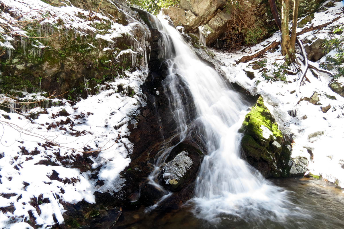
First view of the falls. Bol’Dar was already there !

Bol’Dar at the falls. They are slightly hidden behind the rocks and laurels until you get right to them.
The falls do not look very high at first as there are trees that have fallen, lots of rocks have accumulated at the base and, the laurels on the right side have grown out in front which hides part of them until you get right up to the base of the falls when you can then tell they are much taller than they look from a distance. They are 25 feet in height. There is a narrow but tall feeder falls on the left side that is normally dry in the summer months but was flowing on this trip. Both sides of these falls are pretty steep and very rocky, forming a spine-like barricade that does prevent one from easily going beyond the falls. I recall climbing around the cliffs on the right side some 25 years ago and continuing up the valley until the creek splits in order to know where we were on the map (before the age of GPS and such) but I do not remember any other waterfalls however, going beyond the split up either branch would become very steep so who knows what might be hiding in there. The sun was shining very brightly and as usual was right in the camera lens but we got what pics we could and ate our lunch before it became time to begin the trek back the way we had came. “Love the sound of that shuttah mate ! “

Squibb Creek Falls

Squibb Creek Falls

Squibb Creek Falls

Squibb Creek Falls

Squibb Creek Falls

Squibb Creek Falls

Squibb Creek Falls

Squibb Creek Falls

Squibb Creek Falls

Squibb Creek Falls

Squibb Creek Falls

Squibb Creek Falls
It is mostly downhill going back so hiking is easier and quicker but we did take some time to stop at many of the small falls and cascades that we had passed on our way up, some of which require climbing down a steep bank to get to. Of course this is the only way to get any good views and pics of them so we did take the time to do so and it was well worth it. The first of which is a falls that is almost as high as the main falls which we estimate between 15 and 20 feet. The others are less than this but are all beautiful none the less.

Second largest falls on Squibb Creek

Second largest falls on Squibb Creek

Second largest falls on Squibb Creek

Second largest falls on Squibb Creek

Second largest falls on Squibb Creek

Second largest falls on Squibb Creek
Continuing back down the creek, we stopped to check out more of the small falls and cascades. I took several pics as they are so awesome to photograph.

Small falls along Squibb Creek

Small falls on Squibb Creek

Small falls along Squibb Creek

Small falls along Squibb Creek

Small falls along Squibb Creek

Small falls along Squibb Creek

More small falls on Squibb Creek

More falls along Squibb Creek

More small falls on Squibb Creek

Waterfalls on Squibb Creek

More small falls along Squibb Creek

Small falls on Squibb Creek
We took our time going back but soon were out of the snow zone and back to the dry trail. Soon after that we were at the private house and the trail head. We saw a guy building more ‘stoners’ as his large dog sat in the creek and watched him as we passed by. One was right in the middle of the trail and resembled a bunny rabbit. Another one in a more obscure location beside the creek looked to me like Mrs. Butterworth ! Just after this we were back at the confluence where Squibb Creek enters into Horse Creek and the bridge over Horse Creek where it is then a short walk down the rocky forest road to the car. It had been a great day to be in the woods and we had seen some awesome falls and cascades. I can not wait until the next adventure,,,,,

Customized barrel found near the trail

Tree hugging tree

Private house on Squibb Creek

The Squibb Creek Trail goes over Horse Creek on this bridge (find Bol’Dar)

Horse Creek
To see the complete collection of photo`s from the Squibb Creek Falls, please visit our Photo Gallery here.

 My name is 'RAT' and I love the mountains and waterfalls of the East TN. area where I live and I hope you enjoy this blog about my outdoor adventures.


One Comment to “Squibb Creek Falls – 3-9-2013”