


The Shinbone – 12-07-2016
There is no such thing as an ‘easy Camel Servicer Run’ but, I will say that the Shinbone run is without any doubt, the most difficult one to date. Located in North Carolina yet, only a stones throw from Tennessee, it involves some of the steepest terrain, and thickest laurel hells that I have ever encountered. The fact that it took us nearly twelve hours to go a mere three and a half miles speaks volumes as to how rugged this trek is. The last mile was done in total darkness. I don`t recall ever being so tired and sore from a trip in my entire life. That being said you may be wondering was it worth it ? The answer would be absolutely however, if you were to ask me would I do it again ? I would have to ponder long and hard on that one and the answer might very well be no. There are several pristine, unnamed and dot-less waterfalls hidden within the Shinbone realm that are well protected from prying eyes by the sheer difficulty of the terrain itself. There is not another picture of them anywhere and I feel sure it will remain that way for years to come. I am grateful and privileged to have seen them and I owe it all to our fearless leader Larry Jarret who did the excruciating legwork to find them on two previous trips (down AND back I might add !). On this trip we would use two vehicles and go one way, top down with the full Camel Servicer crew of Larry Jarret, John Forbes, Tommy Warden, my son Tyler Tarpley and myself.

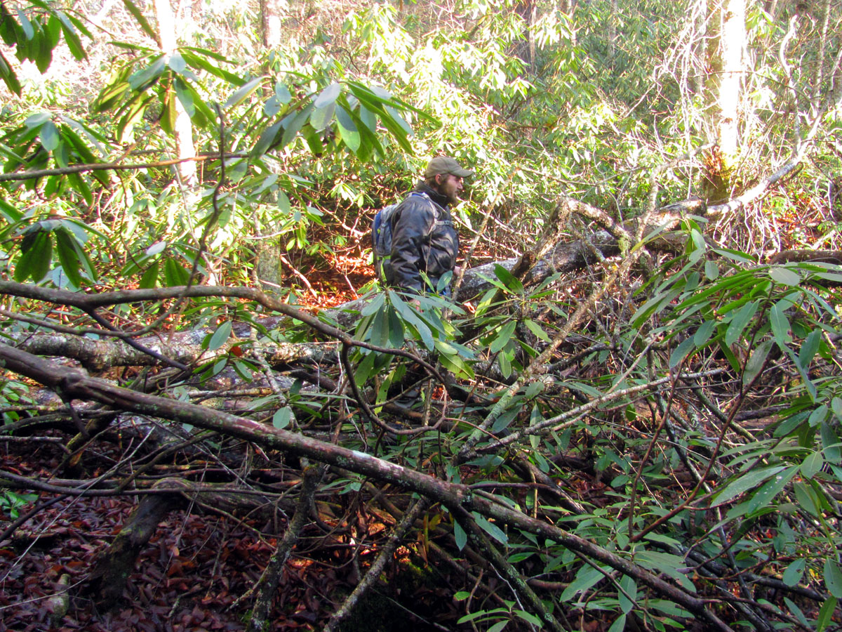
Into the sun and some of the thickest laurels found anywhere with Larry Jarret.
It was a chilly but, sunny December day as we got our usual early start. Dropping off a vehicle at the exit point required one of us to ride in the bed of Larry`s truck as we went back to the top of the mountain. Tyler volunteered. It did not take long and soon we were all hiking down into the gut of the Shinbone. Within two minutes we were crossing a creek and about five minutes later it all turned to crap as the elevation started dropping rapidly and the growth completely blocked any possible routes whether in or out of the creek. It never really improved after that and it actually got much worse in some spots.

Staging area (Photo by Tommy Warden)

Not far from the truck we found ourselves at the creek.
The going got real rough real quick as Tyler looks for a way to go

Barely out of earshot from the vehicle and any form of easy going became only wishful thinking

Tyler and I finding a route (Photo by Tommy Warden)

Early in the game our Gnome friend, John Forbes makes his way along the creek side as gnomes love to keep their feet dry at any cost !

John looking for that path of least resistance. It does not exist on this run. This would be some of the easiest travel of the day !

Looking down the gut. This would be abandoned due to deep water and thick laurels .
We passed by a couple of nice small waterfalls that you could kinda see but, just was not practical to get any closer to. After what seemed like several hours of climbing over, through, and belly crawling under massive amounts of old growth laurels, scrub, and briers, we eventually came to the first few waterfalls but, we were still a good ways from the main event. Getting down to each of the actual falls (and back) was even harder and added more miles and energy spent. Going down the gut of the creek was not an option as it would definitely not be any easier going and there would be places that were very deep and going around them would be just as hard if not more so than the route were taking above it. Not to mention it was too cold to be getting wet and during warmer months the creek would be almost dry. The sun was really bright for the most part of the day so no fancy pics would be possible. The memories however, would be burned into my mind forever.

One of the first waterfalls we could see unobstructed.

Tommy ‘Bol’Dar’ Warden find his path of least resistance (or so he thought) !

Tyler finds himself consumed by the forest

Tyler, Bol’Dar, and myself following Larry down to the next stop ! (Photo by John Forbes)

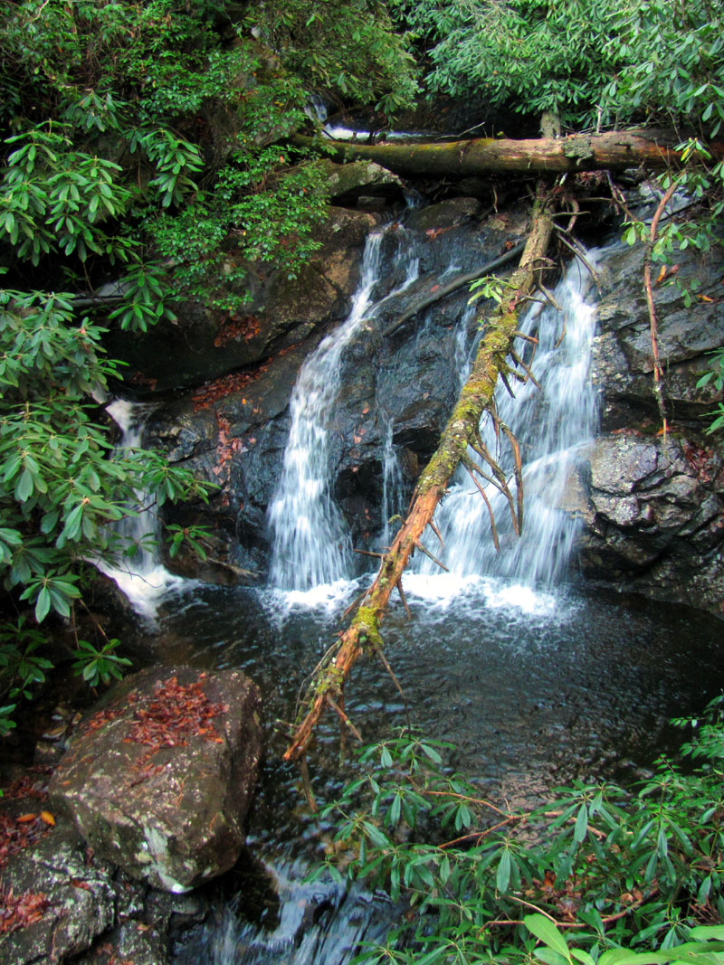
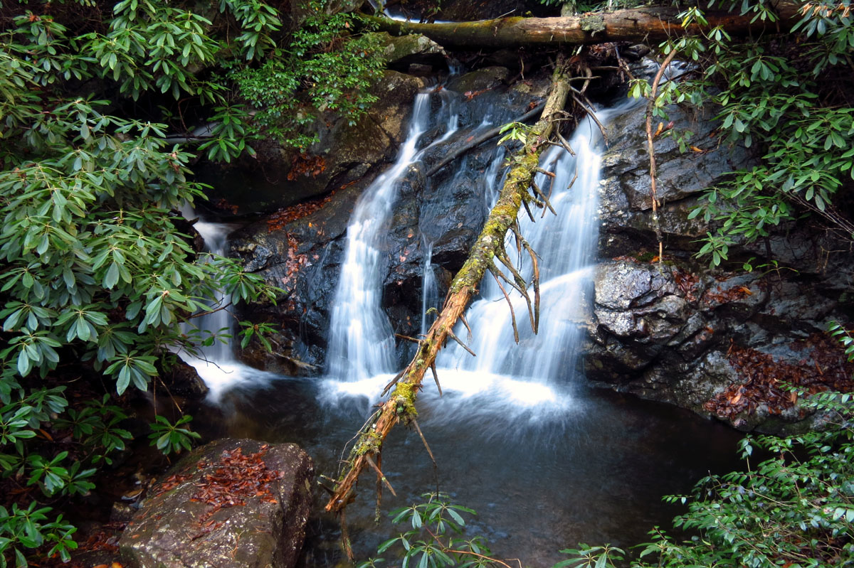
One of the first nice falls we were able to fight our way down to.

(taken with my larger cam)

(taken with my larger cam)

(taken with my larger cam)

(taken with my larger cam)

(taken with my larger cam)

A happy RAT gnome poses at one of the first falls along the run (Photo by Larry Jarret)

Small part of the terrain required to travel down the Shinbone

I think this pic best describes the Shinbone. This is looking down the creek !! Yes there IS a creek there !!! Now imagine going through that all day and into the night !!!!!

back down to the creek to access another falls,,, and no this is not the falls !

Looking back upstream

Tyler and Larry down in the gut as we make our way to a falls

Going down the gut as sometimes it was required

Finally we get our first glimpse of the small falls we were trying to get to !
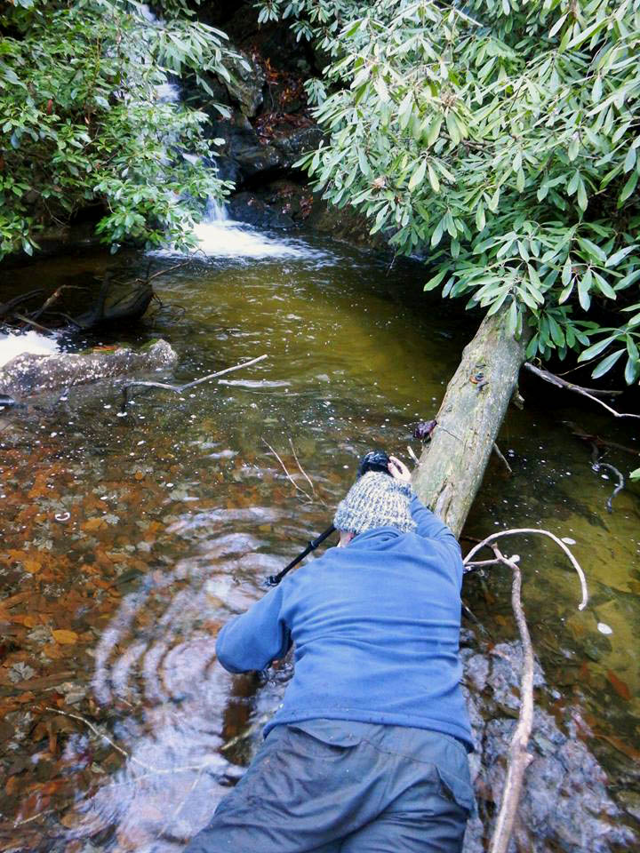
Getting ready to cross under the log ! (Photo by John Forbes)

Me crossing at the log to get to the other side where better pics can be taken (Photo by John Forbes)

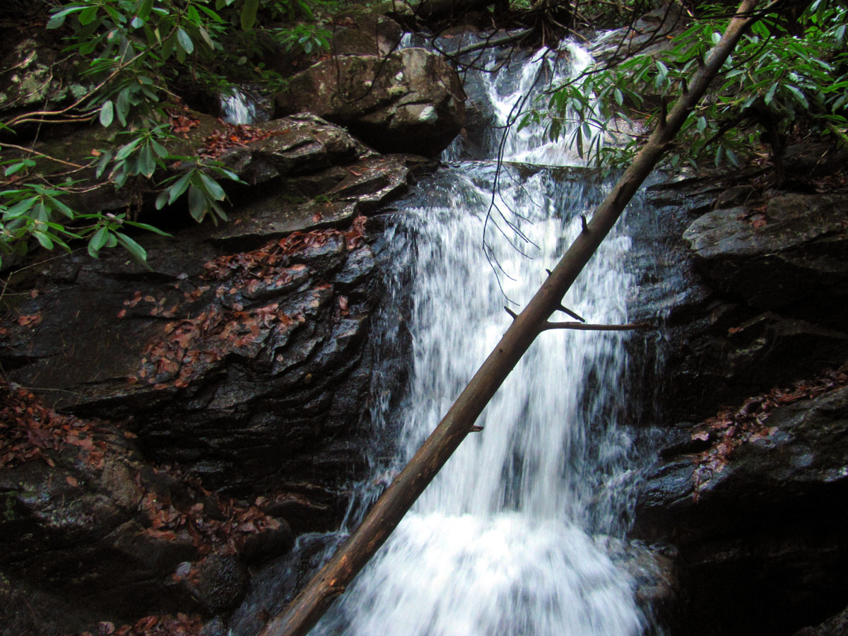
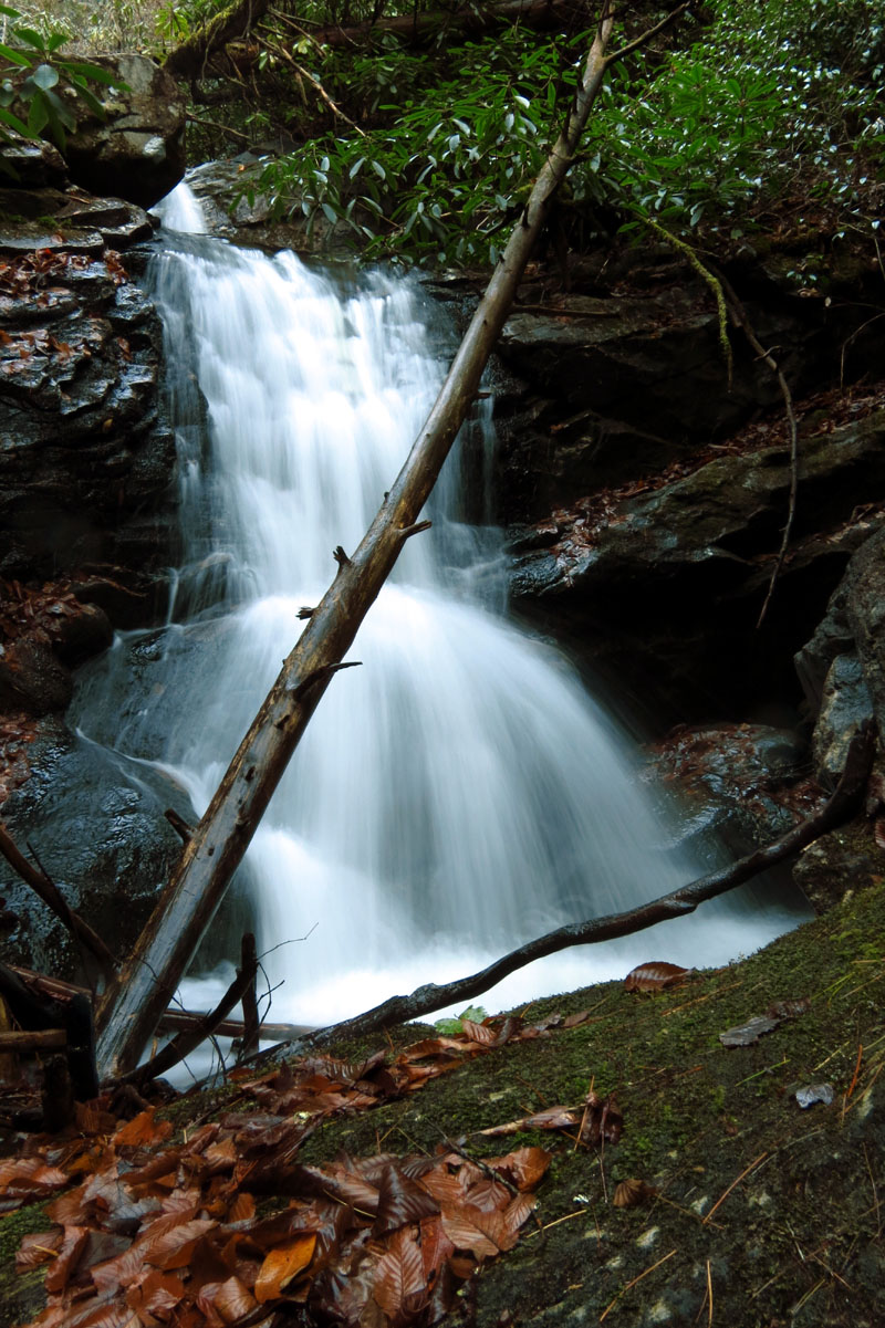
These were a really nice set of falls but, it was very hard getting to them !

Looking above these falls you can see just how overgrown this creek is.

although it blocked some of the view, I think the log was equally as pretty !

John messing around at the falls

John doing a log assisted gnome pose and flashing gang signs at the falls

Small waterfall along the Shinbone

(taken with my larger cam)

(taken with my larger cam)

(taken with my larger cam)

I think that is one of those “Say What ? You`ve got to be kidding me” looks !! (Photo by John Forbes)

Following Larry down the gut to the next falls,,,

Looking back at John as he is finding the route needed to keep his boots dry !

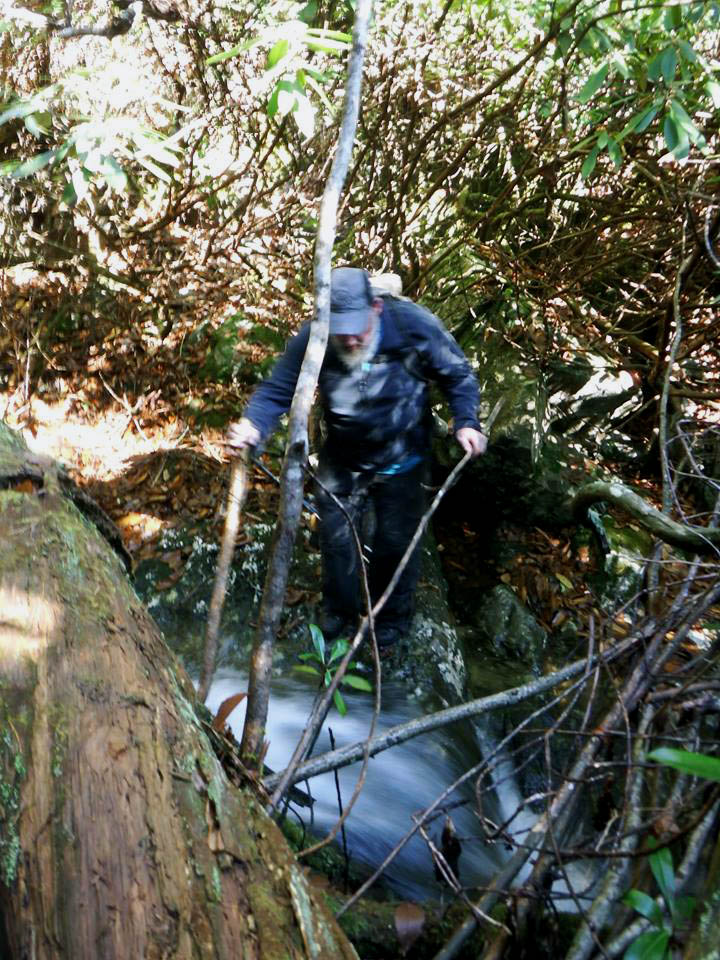
Going around one of many waist to neck deep pools found along the Shinbone. If you look closely in the distance you can see some of the actual Shinbone Rock where the main event lies
It was already well past noon before we would reach the main event, the largest set of falls on this run which was noticeably marked by a huge rock spine that we could see looming high above us as it lined a steep ridge on the opposite side. I only wished we would have had time to climb it as it was quite awesome. I can only assume that IS the ‘shinbone’ ! The creek has actually cut through the base of it and is where one of the main drops is located. Larry led us down the only possible way and soon we would be standing atop the huge part of the rocky spine on our side of the creek which afforded our first clear view of the falls. They were quite the spectacle. From this rocky puckering perch we could see we were also on top of another large falls as there are multiple drops of this complex system of waterfalls. After a break for snacks and cameling up on liquids, we would figure out a way down and around the huge rock formations to get to the base of the upper falls and then eventually an even harder task would be to get down to the base of the lower drops.

Coming down the steep, overgrown, descent, we look like a bunch of escaped criminals ! (Photo by Larry Jarret)

Getting closer to The Shinbone Rock !

Best picture taken of the mighty Shinbone Rock Cliffs (Photo by Tommy Warden)

Tyler takes a short breather (Photo by John Forbes)

Bol’Dar makes his way out onto our side of the Shinbone Rock

Lowest part of the mighty Shinbone Rock

Part of the main event. There is a nice falls you can see part of above these that we would make our way to before leaving this area. There is another large falls just under us as well. These are much larger than they appear !
Upper part of the main falls along the Shinbone. We would soon be standing atop of those logs !!

These are a beautiful falls with an extremely deep splash pool. Way too cold for swimming on this day and way to hard to get to so I doubt I will ever get to swim here.

Part of the main event. Notice the small plume partially hidden on creek right. once atop of these falls we would see if comes from beneath a large rock that is part of the mountain !

(taken with my larger cam)

(taken with my larger cam)
(taken with my larger cam)

(taken with my larger cam)

(taken with my larger cam)

(taken with my larger cam)

(taken with my larger cam)

(taken with my larger cam)

Looking at the small falls seen just above the main falls as we make our way to

Looking downstream from atop the Shinbone rock we could see it was never going to get any easier ! Also note the sun getting low in the sky with another 2 miles to go !

Looking down at the main event falls below us from the log on top !

Looking down on the upper part of the main event falls as we cross the slick log to get to the small falls we saw above them

Checking out the part of the main event falls that forms the plume on creek right we see it comes out from beneath a large rock

View of part of the Shinbone Rock where we were previously at as seen from atop the main event falls (while standing on the fallen logs there)

Larry assumes the position needed to capture a shot of the falls above the main falls

Most of these falls are obscured by thick laurels like everything else on this run !
Me assuming the position needed to capture images of these falls (Photo by John Forbes)

Water level view ! (Photo by Tommy Warden)

(taken with my larger cam)

(taken with my larger cam)

(taken with my larger cam)

After checking out the small falls above the main falls, we make our way back to the Shinbone rock where Larry leads the way to the falls beside it. More of the main event falls that we were previously on top of.

Part of the Shinbone rock (on our side =creek left)

Larry looks back to make sure we are still following him before he disappears around behind this part of the Shinbone Rock

Standing below part of the Shinbone Rock

Looking up from below the Shinbone Rock

And this is what hides behind the Shinbone Rock !

As you can see by the large rock and logs above, this 45 foot drop is actually part of the upper main event falls as the former deep splash pool seen in previous pics empties right over into this lower part of the falls !
This is a magical place

Lower part of this drop as it was just not possible to get into a position to view the entire falls

Me standing at the top of the lower falls taking pics (ones to follow) of the middle section (Photo by John Forbes)

(taken with my larger cam)

(taken with my larger cam)

(taken with my larger cam)

(taken with my larger cam)

(taken with my larger cam)
(taken with my larger cam)

(taken with my larger cam)

(taken with my larger cam)

(taken with my larger cam)

(taken with my larger cam)

This is the third and lowest drop of the main event falls as you can see some of the second drop through the laurels just above these. Adding all three drops( which we consider all one falls) would make these falls close to 100 feet in height.

Lowest drop of the main falls

Here you can see the pointy part of the Shinbone rock with the lower and middle parts of the falls in view. The upper is there it is just hidden by laurels. It really is one huge falls made up of three drops.

Tyler gives some scale to the height of the lower drop (Photo by Tommy Warden)

(taken with my larger cam)

(taken with my larger cam)

(taken with my larger cam)

(taken with my larger cam)

(taken with my larger cam)

(taken with my larger cam)

(taken with my larger cam)

(taken with my larger cam)

(taken with my larger cam)

Hanging out just below the lower falls (Photo by John Forbes)
It took quite a bit of time to maneuver around the three main drops and get what pics we could but, it was a sacrifice that had to be made as I think we all knew that we most likely would not be coming back here again, at least not anytime soon ! Looking back I am sure it did not matter anyway as we were destined to be walking out in dark regardless ! After a grueling climb back through some of the thickest growth I have ever seen we were able to continue downstream passing by at least one more nice sized waterfall.

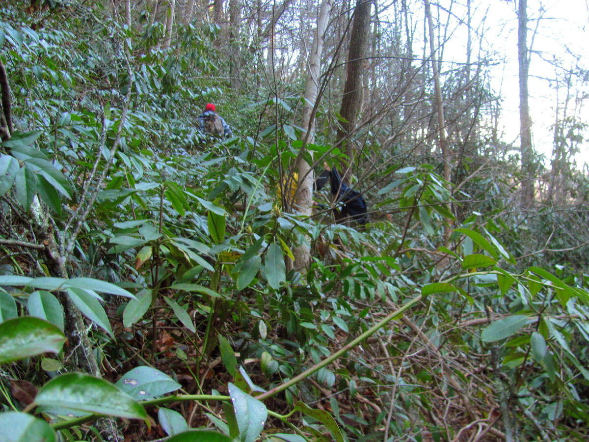
After spending probably too much time at the main event, we continued the journey along creek left through the thick growth

I was happy to see a small talus field as it was easier than crawling through the thick growth. It was short lived however.

Enjoying the only open area on this entire trip (Photo by John Forbes)

Another pic that clearly shows that there is no path within the Shinbone, only the one we would be making. Very steep and very overgrown and very slow going.

John beside another very nice falls we could actually get to well below the main falls

John works to clear some briers out of the shot

Best view we could get of these beauty of a falls

Another shot of these great falls along the Shinbone

I do regret not setting up my larger camera for these.
Our fearless leader Larry, then led us up to a much higher elevation as he informed us that there was another really tall falls not far up an unnamed, side stream that flows into the Shinbone Creek. This led us across more of the same steep side hill terrain across a couple draws and some boulder gardens that would be the only open ground we would see on this entire run. It was very short lived but, much appreciated. We would take a much needed break there before dropping off into the right hollow where the falls we were looking for would be. Larry was spot on as usual and we crawled through the laurels and came out right on top of the falls. It was a huge vertical drop off and was tricky to find a way down to its base. This ended up being directly down the edge of the cliff on creek right via a wet and leave covered, muddy descent. As soon as I got to the base of the falls I crossed the wet leaf covered base and instantly busted my butt which I think attributed to the right elbow injury that I am suffering from now. It was a large and very gorgeous waterfall only it had very little water on it on this day. Larry told us that the main Shinbone creek had much less water flowing on it when he mined out the falls there but, that this side stream falls was flowing much higher then ! Just goes to show that you can never predict waterfalls !

Continuing along the steep side hill through the intense growth gaining elevation as we followed Larry to find the next big thing !!

Looking back at the last falls as I climb higher. I can see Bol’Dar bringing up the rear,,,

another distant shot looking back at the previous falls from even higher above shows another really nice falls in the lower left. There are too many to count along this run but, due to the difficulty there is no way you could get down to see them all.

Larry showing great form as he surfs the Shinbone ! (Photo by John Forbes)

Looking ahead at John and Larry and the disappearing sun, I knew we were never going to get out before dark.

After what seemed like an hour of strenuous bushwhacking, I could still look back and see the last falls with Tyler and Bol’Dar just behind me. I can tell by the redness of Tyler`s hand and nose that the temperature was dropping as fast as the sun was.

Since I have to stop and rest a lot, I get shots like this ! Bol’Dar bringing up the rear !

A meeting of the minds when Bol’Dar caught up to me. I can not remember what was discussed but it musta been important ! (Photo by John Forbes)
Following Larry ever higher through the dense brush I kept wondering what part of ‘top down’ including this much climbing ? lol

This was the highest point we had been on this steep left side route and aside from the one boulder garden was the only open area we would see all day. I was praying it continued but, it ended just beyond where John and Larry are sitting. There is a reason for this high route as Larry would steer us right to the top cliff above the next falls found along a side stream within a very deep hollow which would eliminate a severe bushwhack up to those falls and back allowing us to go one way , which was down through it.

Looking up at a very gnarly tree while we rested beneath it as the light was quickly fading. I kept remembering Larry saying how you would not want to be caught in here after dark,,,,,

We came out right at the top of the falls we were searching for ! Now to get down them !

Looking across the top of the falls. Tyler and I did end up at the tip top of the falls and discovered going down the other side was not a good idea although I did not take any pics until we descended this side.

We were disappointed in the low flow of these falls but, it was a beautiful sight to see anyway. I was just happy to not be in thick growth and to be going DOWN !

Looking across these very tall and nearly vertical falls. These would be amazing during high tide ! I may consider coming back here from the bottom up and back.

The whole time Tyler and I were checking out the top of the falls and looking to see if we could go down the other side, Larry was already at the bottom taking pics !!

Tyler doing a slide for life down the side of the falls ! (Photo by Tommy Warden)

Tyler coming down the side of the falls (Photo by John Forbes)

Almost at the bottom of my ‘slide for life’ down the side of the falls. You can tell I am a tired, fried, RAT ! (Photo by John Forbes)

Getting some pics on my way down while I await John to get to the bottom so as not to cause anything to fall down on him.

Once at the bottom I got some action shots of Bol’Dar as he made the slick descent down to the base of the falls

Bol’Dar making his way carefully down to the bottom.

Looking up at the falls. This would be the last picture I would take with my pocket cam on this trip as it got really tough going and very dark as soon as we left this spot.

(taken with my larger cam)

(taken with my larger cam)

(taken with my larger cam)

(taken with my larger cam)

(taken with my larger cam)
We did not spend much time here as darkness was upon us. By the time we fought the massive growth back to the main stream and crossed it (as our way out would eventually be on that side) it was total darkness. I was exhausted long before we reached this point so the level of difficulty was kicked up to notches unknown to mankind ! The next mile or so to the end of this creek to where it joins yet another creek and more than doubles in size (which also had to be crossed) would be the most difficult trekking I believe I have ever accomplished. It tested the fortitude of each one of us in many different ways. The last mile would take at least two hours to complete. It was slow and arduous going. I know of very few that possess what it takes to complete this run under these conditions. Most would have been crying for their mommies and would require a rescue team to get them out ! (which I doubt is even possible) I recall a whine or two as we fell into an over your head deep hole as we tried to find the path of least resistance in pitch black darkness where headlamps were of little use but, mostly everyone had the patience and backbone that it took to make it through to the end. Crossing the last creek was a tough one as it was raging and was too deep to simply walk through it. No one wanted to risk being swept down and out into the river below us. I recall how relieved I was to finally be on the other side of it knowing we would soon be in a more open area where I could walk freely without having to concentrate on where I would place each and every step to keep from breaking an ankle or leg or plunging down into a deep hole, and not having to constantly push through multiple restrictions that were constantly holding me back. We were all totally drained yet filled with satisfaction as a result of the accomplishment. I barely remember the ride back to Larry`s truck and then further on to Tommy`s car and even less of where John, Tyler and I would go for the post hike grub out as I never took another picture after the last waterfall ! I think we went to Ole`s Mexican restaurant in Johnson City about a half hour before they closed. It took me about 5 days to recover from this adventure as the next Camel run would be approximately 6 days later. Until then ,,,,

Signs found in black darkness (Photo by John Forbes)

 My name is 'RAT' and I love the mountains and waterfalls of the East TN. area where I live and I hope you enjoy this blog about my outdoor adventures.


Leave a Comment