


Waterfalls of Panthertown Valley (NC) – 12-19-2014
On this adventure my friend Dave Aldridge and I would be attempting to see the Upper Dismal Falls and as many others as we could in the process. After a sausage biscuit from Clarence`s in Unicoi and the long drive down, we would begin this journey not at the traditional parking area as seen on the map but, instead we got permission to park at the nearby outdoor therapeutical camp for boys (formerly called Camp Winding Gap but, is now called Trails Carolina) where there is a little known shortcut trail that leads into the main trail. It was a beautiful day for hiking but, too sunny for taking pictures which seems to be the norm for me. Only minutes from the car we found ourselves at the side trail to Aunt Sally Falls (or so we thought) which we decided to skip on the way in as we had bigger fish to fry and a limited amount of daylight to accomplish it in.
Upper Dismal Falls
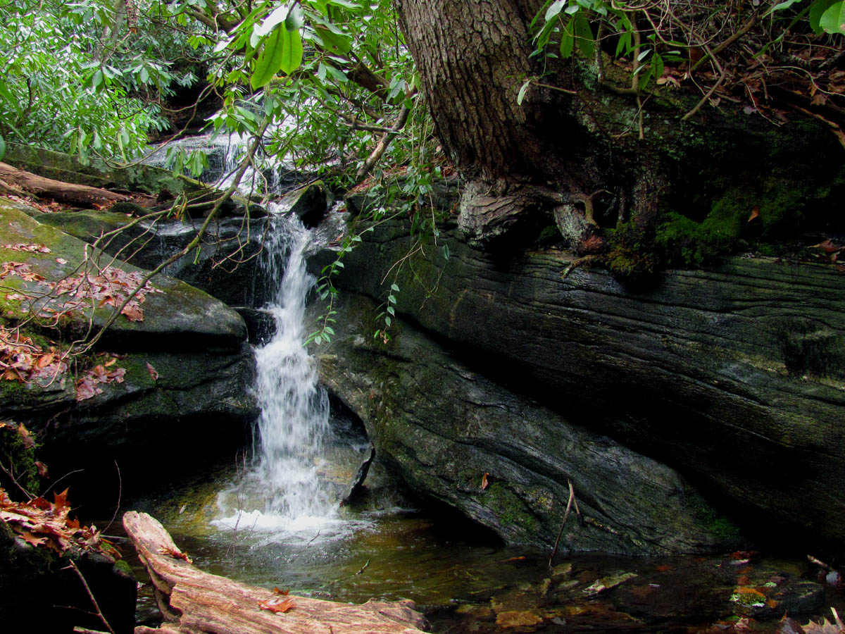
From there we would continue on what is called the West Fork Way Trail which passes under some power lines then crosses a few small tributary streams and eventually comes along side a main stream called West Fork which is actually the West Fork of the French Broad River. There is a tricky spot where you have to take a left off this main trail through a small campsite where you cross the main creek and begin the assault on the hill that would lead us up to the falls we hoped to see. You will soon hear a creek on your right yet, this is NOT Dismal Creek ! As a matter of fact this creek is not even on any topo maps ! It is not far to the first falls and if you are looking for them you will not miss them. These are unnamed but are definitely worth stopping at.

West Fork of the French Broad River

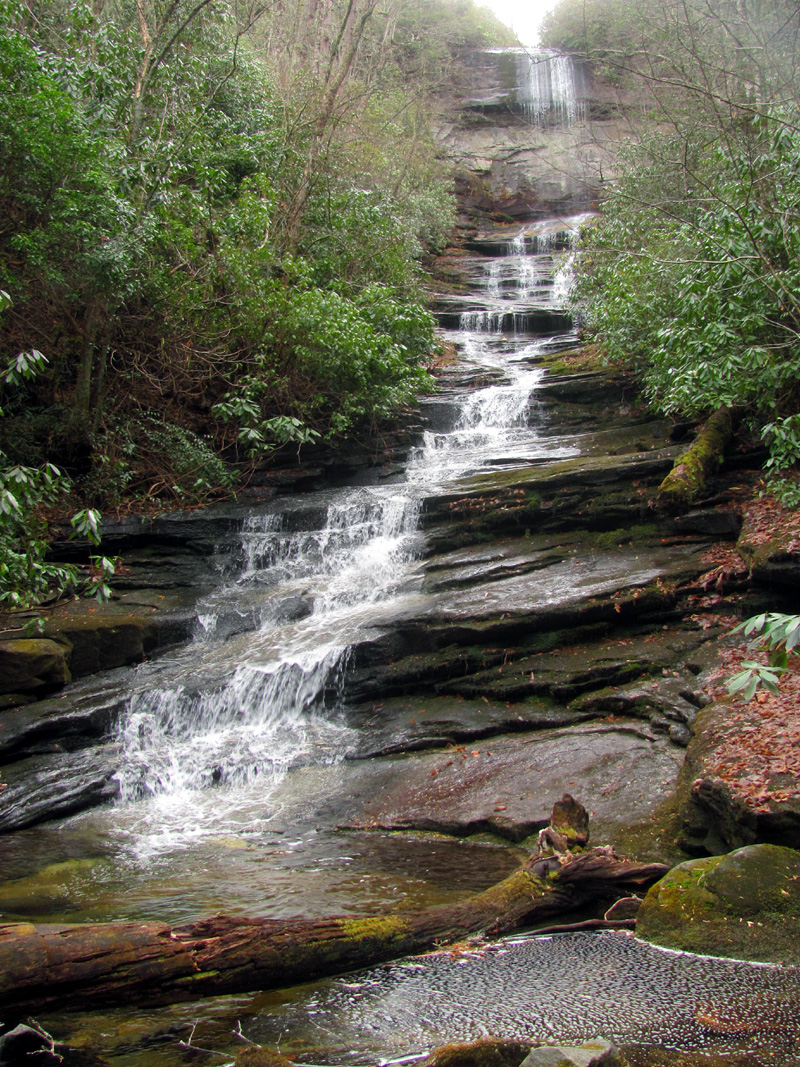
Unnamed falls downstream from Rhapsodie (Grotto) Falls

Unnamed falls downstream from Rhapsodie (Grotto) Falls

Unnamed falls downstream from Rhapsodie (Grotto) Falls

Dave taking pics of the Unnamed falls downstream from Rhapsodie (Grotto) Falls and I am just below them as this little beauty was found there
Continuation of the Unnamed falls downstream from Rhapsodie (Grotto) Falls

I consider these actually part of the Unnamed falls downstream from Rhapsodie (Grotto) Falls

Yours truly at the Unnamed falls downstream from Rhapsodie (Grotto) Falls

Dave at the base of the Unnamed falls downstream from Rhapsodie (Grotto) Falls
From there you continue up the trail by some really large and very cool rocks on the left. The first of which looks like a boat that has marooned itself on dry land. The next one found farther up the hill is HUGE and has a rock shelter on its lower side large enough to accommodate several tents ! This one would be aircraft carrier sized ! We took a break here to check it out.

The ship rock

To show how large the ship rock is, this is Dave standing beside part of it.

Dave taking a break under the multiple roofs of the aircraft carrier rock
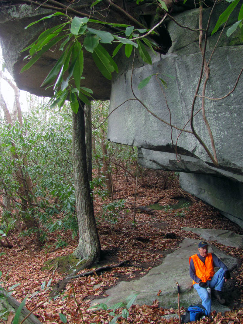
Due to the steepness of the hill where this rock sits, it is impossible to show how large it is with a picture. Dave relaxes on the campsite beneath it

Dave beneath the mighty rock.

I must assume there is much rock in the ground as there is showing. The top is fairly level and you can stand upon it and yes, it IS like standing on the deck of an aircraft carrier.

I would love to camp here sometime. The tree is grown into the rock high above.
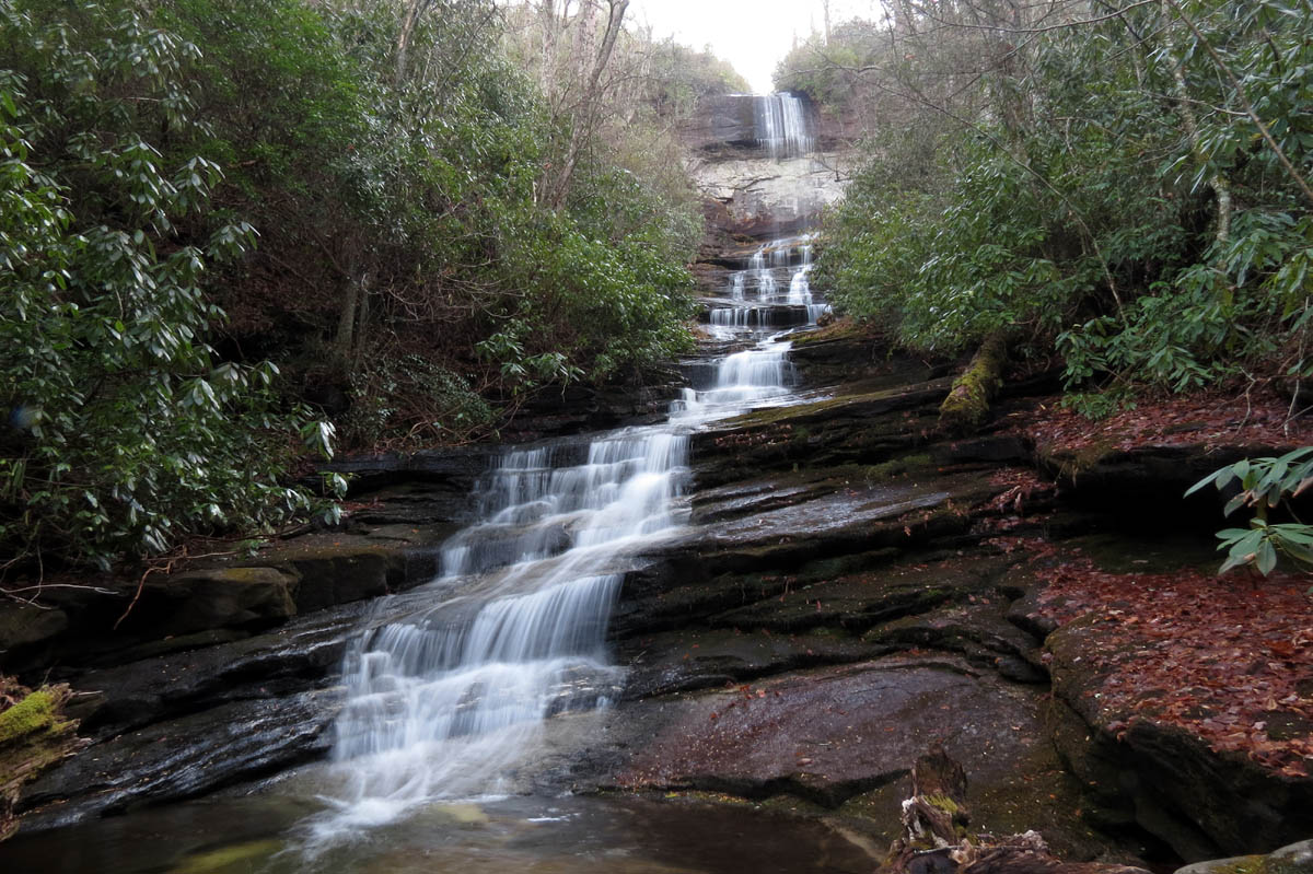
Once back on the trail you will soon find an obvious side trail off to your right leading towards the creek. The first one is actually a false trail so go a little farther to find the real trail. It will be obvious. This will lead you over and down to Rhapsodie Falls or Grotto Falls as it is listed on the Panthertown map. These falls are nearly 90 feet high and are beautiful. You can walk behind the falls but, please tread lightly as there is very fragile vegetation that grows in the mosses there.

Cool tree found at the entrance to Rhapsodie Falls aka Grotto Falls

Rhapsodie Falls aka Grotto Falls

Rhapsodie Falls aka Grotto Falls

Dave beside Rhapsodie Falls aka Grotto Falls

Dave standing beside these 90+ feet high falls = Rhapsodie Falls aka Grotto Falls

Dave behind Rhapsodie Falls aka Grotto Falls

Looking out from behind the falls

Rhapsodie Falls aka Grotto Falls

Rhapsodie Falls aka Grotto Falls

Rhapsodie Falls aka Grotto Falls

Rhapsodie Falls aka Grotto Falls

Myself at Rhapsodie Falls aka Grotto Falls (Photo by Dave Aldridge)

Myself at Rhapsodie Falls aka Grotto Falls (Photo by Dave Aldridge)
We spent some time here enjoying their immense beauty before going back to the main trail which will continue up the hill and then crosses over the ridge away from this creek and more towards Dismal Creek. Once on that side of the ridge the trail will bear right and start climbing what will become a very STEEP hill. Not far up this way there is a faint trail that leads off down the steep slope to the left. This is the way down to Dismal Creek if you wish to go to Lower Dismal Falls. We had our sights set on making it to the upper Dismal Falls so we did not take this side trail however, this would lead down to what is known as the Great Dismal Wall which is definitely worth seeing if you have the time and feel adventurous. Following the wall until it meets the creek you would then have to climb over many LARGE boulders up and around the bend to see the lower falls. Please be very careful here as an injury would be a serious ordeal due to the inaccessibility for the rescue team. Continuing up this creek to get to upper Dismal Falls is possible but, only for the very experienced extreme hikers or for the very stupid hikers with a death wish. I recommend going back the way you came to the ridge trail and continue that way.

Lower Dismal Falls (Photo by Dave Aldridge taken on a previous trip Summer 2014)

Crossing over the ridge about to begin ‘the climb’
We continued climbing the incredibly steep trail straight up the main ridge that was relentless and seemed to go on forever although it really isn`t that far. The faint trail was hard packed and covered with leaves and I found myself using both hands almost on all fours to get up it to keep from losing traction and sliding backwards. I was studying the area closely as I went and vowed I would find a better route on the return trip as this would be a butt scoot slide coming back this way. I was elated when I made it to where another faint trail was on the left that seemed to drop off the edge of the world into the Dismal Creek canyon where I knew the upper falls would be. This was almost to the top of the ridge we were on but, not quite. I rested there while I waited on Dave to catch up with me.

After about halfway up, there was one short level place before it went up again even steeper.
Then we began this insanely steep descent the whole time thinking how bad this was going to be to climb back up. There are various colors of flagging tape found here that lead in every direction as multiple routes snake their way down, down, down, into this deep gorge-like ravine. I eventually came to a vertical rock wall where there was the first place to actually stand on level ground as I walked along its base.

Looking back at Dave on part of the incredibly steep descent

This was an amazing rock wall and I was happy there was a narrow path around this formidable obstacle

First view of the falls (still a long way down to go !)

This was Dave`s only view of the falls as he stopped here but, has vowed to come back and climb all the way to the base next time when we have more light hours. (photo by Dave Aldridge)
From there it continued straight down dropping one level at a time until I could finally see a small glimpse of the falls. It was at this point where Dave called it quits as he was very worried about having the energy and daylight needed to climb back out. I went on down to the creek and tried my best to convince him to continue as I knew he could do it but, was not successful. This being said I finished the descent to the base of the falls and sat down on one of the large logs there at its small yet, inviting splash pool and stared up at her in awe. This was a place that not many see and it is absolutely stunning.

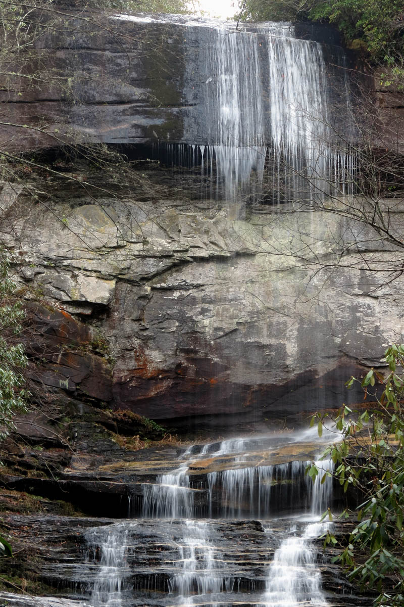
Upper Dismal Falls

Upper Dismal Falls

Upper Dismal Falls

Upper Dismal Falls

Upper Dismal Falls
Upper part of the Upper Dismal Falls

Upper Dismal Falls
Upper Dismal Falls

Upper Dismal Falls

Upper Dismal Falls
The light was still too bright for any really good pics but, was improving as the sun was setting. The bad part about this was the longer I stayed here the more my chances of not making it out before dark went up. I set up and began taking pictures trying to get what I could for as long as I thought I had time for. I even took the time to get a selfie or two and eat a banana before packing it up and beginning the arduous climb out.
Surprisingly enough it did not take me long to get back up to where Dave was, and even more surprising how much easier it was to climb back to the ridge than either of us had anticipated. It was at that time Dave realized the mistake he made by not going on down to see the falls. Oh well, just another reason to come back is how we see it.

Standing at the base of Upper Dismal Falls if you turn around and look down stream, this is what you see. It drops off the edge of the world here and continues until it reaches Lower Dismal Falls

Looking up at the first part of my climb back up. Dave is somewhere up there just out of hearing,,,,,
I made it to the ridge line first and rested while I waited on Dave to make the last leg of the climb. After a good rest there and some water, we started back down only this time I veered way off to the left into a nice hollow I had spied on my way up that ended up being a much better way to go. It was on a much more gradual slope and the ground had not been packed down so the footing was great. Following a major animal trail it was very direct and led us all the way down until it intersected the main trail where it crosses over the ridge from Rhapsodie Falls. From there it was back down by the big rock shelter and soon we were crossing the West Fork of the French Broad River where we had crossed earlier. Back up through the small campsite and back on the main West Fork Way trail where we could make much better time.

Dave gasping like a fish out of water as he made the arduous climb out of the Dismal Creek Gorge

I can almost see the top !

Looking down at Dave as we climb out of the ravine
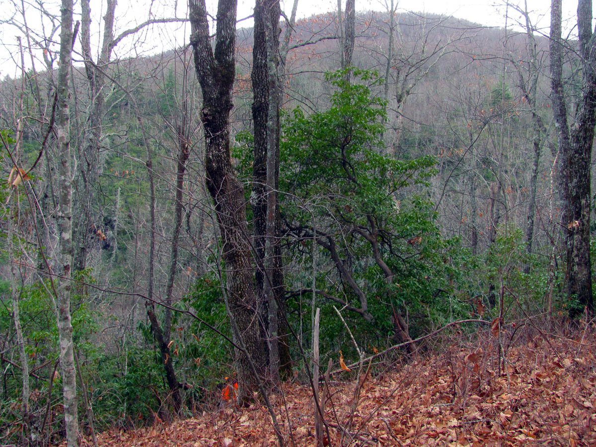
Dave on his final ascent as I sit on the ridge catching my breath. That is Big Pisgah Mtn in the background on the other side of the Dismal Creek gorge

My view from the ridge. You can see we are fairly high in elevation and it is getting dark.

Looking down the steep ridge in the direction we needed to go back however, I would not be going back that way as I would take a left here and veer over into a hidden hollow I had found on my way up that was much less steep and way easier to walk on

Going down the hidden hollow making life much easier (and quicker)

Dave coming down my newly found route, happy that he is not butt scooting down the steep ridge we climbed up on !

In no time we were back down to the rock shelter !

Continuing downward we passed back by the ship rock

The ship rock has some odd dips in it

Back on the main West Fork Way trail

Looking back at where had just been. That notch is the gap where Dismal Creek flows between the high ridge we were on (right) and Big Pisgah Mtn (left)

Making good time now on the West Fork Way
It was getting really close to dark but, we hustled in hopes of being able to get to Aunt Sally Falls before it was too late. We made it and Dave was able to get some shots but, mine barely turned out due to my low f stop ability. At least we got to see them and for that I was happy however, although we did not know it at the time, this short side trip would end up costing us which I will soon explain.

Large rock at a campsite near Aunt Sally Falls. it was nearly dark at this time.

Aunt Sally Falls

Aunt Sally Falls
On our way in on the shortcut trail we had seen the trail leading off to the right which we knew (assumed) was the trail to Aunt Sally Falls. This being said we ‘assumed’ that was the only trail to those falls. What we failed to realize was that since we did not come in on the main trail from the parking area on NC 281, that there would actually be two trails ! That trail we saw leading off to the right that morning which we assumed was the side trail to the falls was in fact the main West Fork Way Trail coming in from the parking lot and there would be another trail, a side trail off it to the left that would lead to the falls. Where we made our mistake was not seeing the shortcut trail (one we came in on that morning) on our right as we came out (due to it being an obscure trail and it being almost dark) which put us on the main trail to the parking area where in only a hundred feet or less we then saw the side trail to the left that took us left to Aunt Sally Falls. This was all good at the time but, upon coming out instead of taking a right from there and backtracking only a few feet to pickup the shortcut trail which would have gotten us to the car just before pitch dark, we took a left thinking that was the trail we had came in on that morning !! NOT !!

This large campsite is on the shortcut trail we had taken that morning when this pic was taken. It was hard to find this again in the dark !
After walking at least 15 minutes crossing a creek a few times and going down a short hill, we realized that none of that was right. We could also see a prominent ridge to our right which we knew was wrong as we should have been looking down into the West Fork Way Valley. Plus we also realized we had not crossed the poop log (see picture below) Knowing we had not seen any trails on our right, we stopped when it got completely dark and put on our headlamps and continued walking. After a total of 30 minutes we came out at a gate and the parking area on NC 281 ! What we should have done then was walk the road to the right and down to the gravel road to the camp and our car but, I had left my hiking stick laying on the ground where I stopped to get my headlamp out and besides, I was determined to figure out the mystery of where we went wrong.

Speaking of mysteries, I wonder what left this poop on that log ? We had crossed over this log earlier that morning on the shortcut trail and since I took no pics of us in the pitch dark felt obliged to include it here for space filler !
That being said, we backtracked about 20 minutes or so to find my stick and back to the side trail that led to Aunt Sally Falls and still could not find the shortcut trail. It was like being in the twilight zone. I knew it could not be the other way,,, or could it ? Having no other choice other than walking all the way back to the the road again, we checked it out and sure enough we found the hidden shortcut trail and then realized our mistake. This goes to show you how easy it is to get disoriented and misplaced in the woods especially when it is dark even for the most experienced hikers. Of course I was never actually lost and my only worry was not making it to the Hawg Wild Bar B Que joint in Brevard, NC before they closed. We took our time on the shortcut trail and within another 20 minutes we were back at the camp and our vehicle and we did make it to the post hike grub out in time. Since it was a Friday, there were some musicians there playing Bluegrass which made the experience that much better. We filled our bellies with some good Q and tea before beginning the long ride home. It had been another excellent day in the Panthertown Valley and I was already anxious to come back so that I could see the lower Dismal Falls and get Dave down to the uppers. Until next time,,,,

 My name is 'RAT' and I love the mountains and waterfalls of the East TN. area where I live and I hope you enjoy this blog about my outdoor adventures.


Leave a Comment