


Flat Creek Falls Overlook – 4-8-2017
I was invited to attend a group hike led by The Badger (Thomas Mabry) in hopes of finding the covert location of the only overlook where Flat Creek Falls can be seen in its entirety. This location has only been documented by a couple of people, one of which being Kevin Adams who is a well known North Carolina Waterfalls author extraordinaire. Flat Creek Falls is located at the Northern edge of Panthertown Valley within the Nantahala National Forest and is listed at 200 feet high.
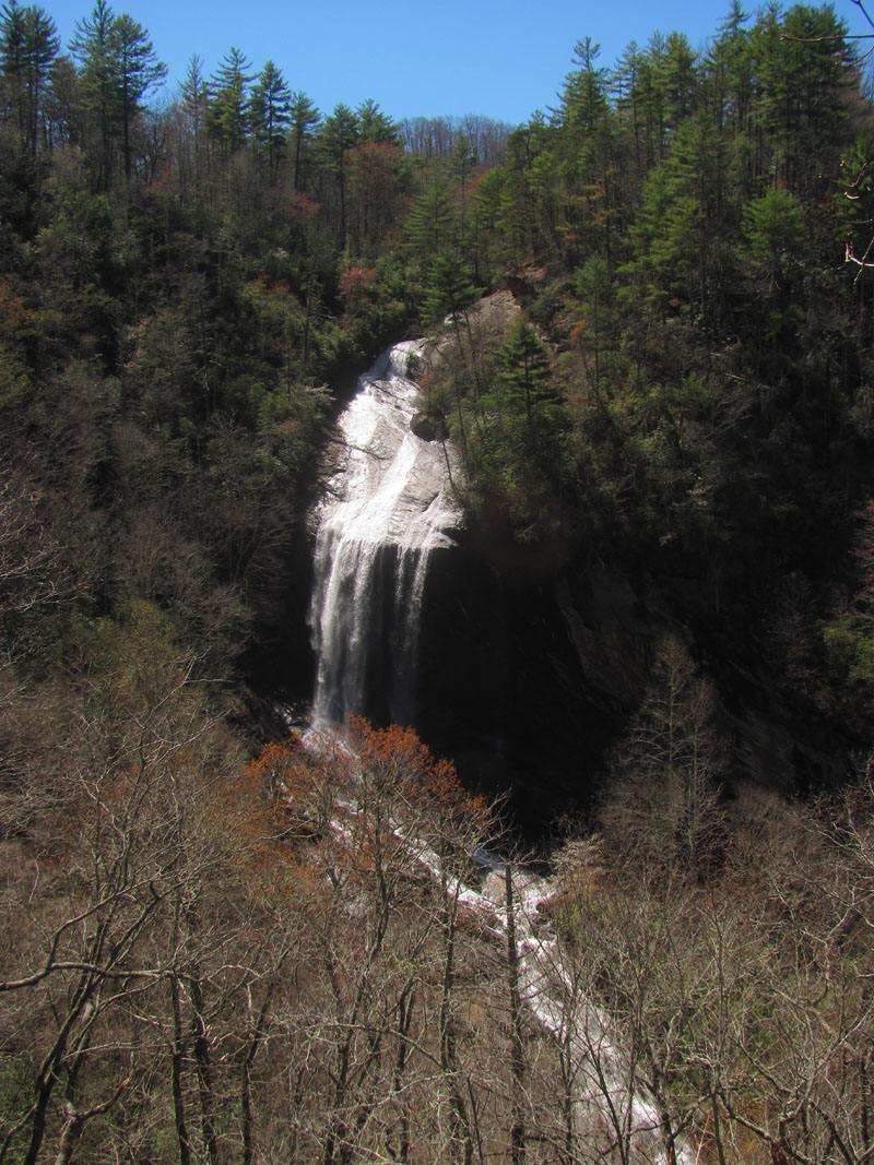
Flat Creek Falls (Panthertown, North Carolina)
As per my last visit to them with my old friend Dave Aldridge and his trusty hypsometer, it is actually higher than that. On that previous visit which was our first time being there, I noticed the overlook from the top of the falls and after checking from the base I knew climbing up to it would not be a feasible route. Map studies revealed farther downstream it might be possible to climb up a very steep ridge and also with a nasty bushwhack and some mad map/gps skills it would be possible to go from the top of the falls by crossing the creek and swinging very wide to get over to it but, the best (and safest) way would of course be from top down. The only problem with that is there are no marked trails and several different ridges and mountain knobs would have to be negotiated and bushwhacked to reach just the right spot. There are no listed gps points for it. There is another factor that also must be considered and that is no matter what route you take to these falls and the overlook, you WILL encounter private property. It requires the right topo maps and some serious navigation skills to be successful. Lastly, even IF you do make it to the correct knob / ridge there is no way to know exactly where to go down the near vertical, overgrown, descent at and, with the overlook cliff being so small you can easily miss it as we did on our first couple of attempts. When that happens you get to a point to where you can not go down any farther (without ropes) due to the steepness and you have no choice but to climb back up (very exhausting) and try another place on the knob. It is extremely overgrown and laden with rocky outcrop obstacles so going side to side really does not work here. Using a collaboration of experience and having a large group allowed for us to compensate for this and explore multiple locations in a shorter amount of time until we finally found the G spot of this elusive creature. Although we were all elated to finally be at this celestial place, all hopes of getting even one satisfactory picture were dashed by the intensely bright sun and of course there was not to be a cloud in the sky all day. This only means one thing, that I have to come back when the conditions are better !

Team RAT arrives ! (notice it was cloudy when we started !!) (Photo by Thomas Mabry)

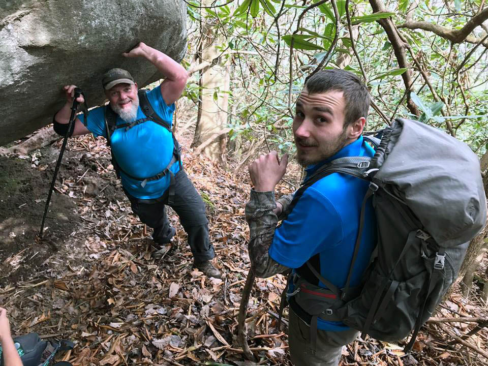
My son Tyler on one of the many climbs

Daddy RAT and Little RAT ! (Photo by Thomas Mabry)

Following the ‘Badger ByWay’ we came across this really nice rock formation that we rested at before continuing to climb up an insanely steep hill ! (so it technically was NOT a pointless climb !!)
Tyler and me at the lower end of this cool rock formation we rested at on the first climb. (Photo by Thomas Mabry)

The Badger climbing like,,,,,, a badger !

John Forbes and Scott Burns discuss some of the finer points of moonshine at an old barrel we came across. I do not recall if I told them it was just an old hunters fire barrel or not ? ,, hmmmm,,

Old barrel most likely used by hunters to keep warm in the winter time.

A really old Quaker State oil can found at the old barrel. Probably used as an accelerant in starting fires.

Looking way across the valley we could see a rather distinct and vertical falls. Kitty informed me it was Slatten Falls.

Zoomed as far as I could and it is definitely a large vertical waterfall. I have confirmed it is Slatten Falls and yes it is now on the list !

The Badger checks his GPS as he leads us in the right direction through many twists and turns and numerous ridge intersections.

Me, my son Tyler, and John Forbes, hanging out on the ridge before attempting to descend towards the overlook. (Photo by Thomas Mabry)

Descending the super steep and overgrown hill towards the knob. You can see me and Tyler down below to get an idea of how steep it is at only 30 feet apart (from badger`s feet to the lowest person seen in this pic) (Photo by Thomas Mabry)

My first view of the falls as seen over top of John`s head !

We all prayed for a cloud but, it was not meant to be

This tiny rock knob was wet, covered with moss that would break loose with the slightest touch which made it extremely difficult to hang out at. Very dangerous as one slip here would not end well.

You can see how vertical this rocky cliff is. You can also see how vertical the side of all the ridges are around these falls and how wide you would have to swing out to come to this point from the top of the falls in an overgrown hell.

Getting any decent pics was not possible.

Flat Creek Falls
I am pretty sure this was the best picture i got of the falls.

Literally hanging on to the overlook rock

The Badger got way better pics than I did !! (Photo by Thomas Mabry)

Luke Wilson ? Whipped out his trusty rope and gear and disappeared to the bottom. I think he went to the base of the falls on this day and came back a different way. (Photo by Thomas Mabry)

Luke going down !! (Photo by Thomas Mabry)

Here you can see how steep it is at the overlook as The Badger works on getting pics. if you were to slip off this extremely slanted rock you would fall into the tree tops !!! Note the rope where Luke is rapelling on somewhere way down below ! (Sorry I have no clue who took this picture !)

Zoomed shot and probably the best picture of the day (Photo by Thomas Mabry)
I attempted to use my larger camera (since after all I did carry it all the way there!) hoping that the Neutral Density and Polarizing Filters would make a difference but, alas they did not. I just could not get it dark enough without ruining the shot. Here are a few of my futile attempts:

Flat Creek Falls

Flat Creek Falls

Flat Creek Falls

Flat Creek Falls
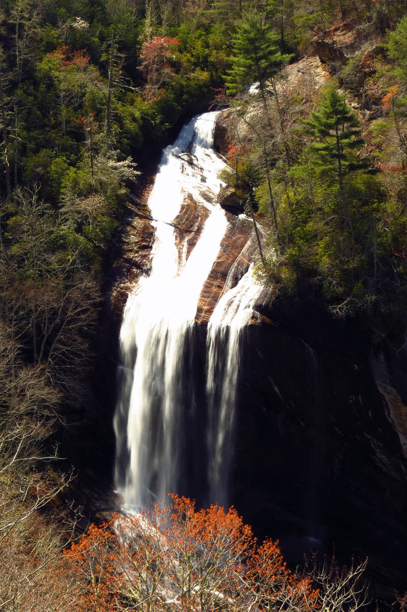
Zoomed shot , about as good as I could get on this day,,

Zoomed image of part of Flat Creek Falls
It was a long and very arduous hike yet, extremely rewarding ! Tyler and I found an easier section of the route on our way back to the car which should prove to make it better if we get to return to this amazing area again in the future. Tyler has not yet been to the top or base of the falls which I am sure we will be doing before returning to the overlook. Then again we may be able to do both although, that would be a long loop hike ! It was a grand hike despite an expensive camera being left behind which meant that not all who went in came out together but, all did eventually come out and the camera was found. The post hike grub was almost as good as the hike was ! I am already looking forward to the next big adventure. Until then,,,

My post hike grub !! Salmon and Steak !!

 My name is 'RAT' and I love the mountains and waterfalls of the East TN. area where I live and I hope you enjoy this blog about my outdoor adventures.


Leave a Comment