N. Harper Falls, Chestnut Cove Br. Falls, and Little Lost Cove Cliffs – 12-28-2013
I finally got the pleasure of meeting and hiking with my friend Sam`s nephew Houston Kilby on a trip with them, Bol’Dar and myself that we took at the end of December, 2013. It was a cold day and there was some ice but no snow and the water level was decent. Of course any higher than normal water levels anywhere on Harper Creek means adventurous creek crossings and there are plenty of them. Starting around 10 am at the North Harper Creek Trail #266 located on FR#58 we began our descent into the Harper Creek Valley. It is not far to the first creek crossing where the fun begins.

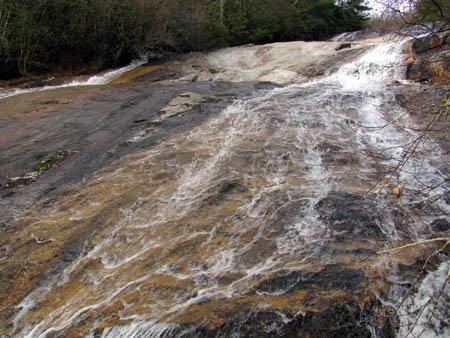
Cascade part of North Harper Falls (note: that is not the top seen in this pic, there is some more to these above what you can see here)
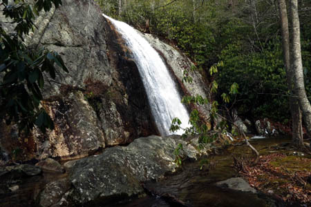
Although it is not that far to the top of the North Harper Falls, there are several creek crossings. Each of which is not easy when the water is up and the exposed rocks are icy slick however, no one had any incidents on this trip. The top part of the falls is a long cascade that is at least 200 feet down to where the water drops off a 45 foot high vertical falls at the bottom. On my last trip here was during warm weather with not as much water flowing so I was able to walk most of the way down the face of the rock and then down a small trail along the left side of the falls to come out again at the top of the vertical falls. From there I was able to jump across the main water flow and walk over to the other side where I took a nice shortcut down to the base. It was too icy to stand on top of the vertical falls today. This does cut out a lot of trail because to reach the bottom of the falls you must follow the trail up a hill to an intersection where you have to go right and back down a steep hill to find the bottom of the falls. It`s quite a ways around but on this day due to icy conditions and higher water flowing there would be no venturing out on the top of the falls. It was just way too risky so we had to do the extra distance to get there on the trail.

Looking back at the first creek crossing where the creek is at its narrowest . Of course we crossed upstream some, I apparently caught a Samurai Ninja as he flashed by me !
After finally reaching the base of the falls, we took a long lunch and enjoyed the beauty of these falls and the area around them. It was a cloudy day but for some reason neither Bol’Dar or myself could get any good long exposure shots of the falls. Not sure why because it did not seem that bright but apparently it was or it could be that we just don`t know what we`re doing !
After lunch I decided since we were so close that we would go a short ways downstream to see the Chestnut Cove Branch Falls. We actually passed them up and had to backtrack to find them. I do not recall them being that hard to find the last time I was there but we were coming in from the other way. There is not really an open or marked trail to these falls but they are worth finding. These are also a cascading type falls that are over 100 feet long and there is a small falls at the bottom left of them where the Chestnut Cove Branch flows into the North Harper Creek. There are lots of potholes in the rock of these falls all the way to the top and is where we found several large Northern Water Snakes living on our last trip here. They were living well on the frogs, tadpoles, salamanders, etc that lived in these holes. It was too cold for snakes on this day and too slick to be walking around on the rock.

Looking down the Chestnut Cove Branch Falls. There was too much ice to even think about walking down them.

This is the actual Chestnut Branch that flows into the North Harper Creek at the base of the Chestnut Cove Branch Falls and obviously where they got their name
From those falls, we went back the way we had came, across all the many creek crossings to reach the vehicle but, it was still fairly early so I suggested we drive down to the Little Lost Cove Cliffs to check them out which we did. The cliffs are on FR#464 just a few miles below where FR#58 starts so it only took a few minutes to reach the trail head. Since we did not have two vehicles we could not do the loop so we parked on the higher end which is the first trail head you come to going in the direction we were going which is less climbing but doing the loop from there to the lower trail head is the way to go if you can. There is a climb to get to the top of the ridge and the cliffs but it is not that bad and not very far so we were there in no time.

View from the first cliff (Looking at the lower part of Big Lost Cove Ridge, Note: the Big Lost Cove Cliffs are on the backside of that part of the ridge. Other noteworthy things seen here is the beginning of the ridge that leads to Grandmother and Grandfather mtns., and the dead end road above Little Lost Cove Creek)

View from the first cliff (looking over Little Lost Cove and Lost Cove valleys with Grandfather Mountain in the background)

View from first cliff (looking down at Little Lost Cove Valley and the road there, Lost Cove Valley, Beacon Heights (tower), and Grandfather Mtn)

View from the first cliff (looking farther Eastward over the Lost Cove Valley and beyond Grandfather Mtn towards Blowing Rock)

View from first cliffs (looking more East to see the other set of Little Lost Cove Cliffs and more NC mtns)

View looking behind the other set of Little Lost Cove Cliffs where the Harper Creek Valley is (that would be Persimmon and Long Ridge on the other side)
The Little Lost Cove Cliffs are basically in two parts. The smaller ones come first going this direction and there is a fairly long side trail that leads to the left off the main trail to reach them. We went there first and checked it out. The views are good from either cliffs weather permitting.

Looking off the second set of Little Lost Cove Cliffs over the Little Lost Cove Creek Valley towards Grandfather Mountain
There is a huge cave like area on the side of the large cliffs which can be seen from the smaller ones. Bol’Dar and I checked them out getting as close as we could to the top of it and I also found a nice trail on the way back that leads off the main trail that obviously leads down into the low spot and that cave area and the base of the cliffs. You can bet that I will be back to explore that one day.

Bol’Dar and I went down this steep slope of the far left side of the second set of cliffs to check out the overhang and cave area below it. This is looking back up the way we had came across the ice.

Making our way down to the overhanging rock above the small cave area below. The first set of cliffs is in the background.
From there we went back to the main trail and continued down into the gap and back up to the larger of the cliffs. The side trail there is much shorter and you basically walk right out on the cliffs. The views are much better from here as you can see off the lower side to the East to see the North Carolina mountains as far as the eye can see. From the main trail you can see Table Rock and Hawksbill way off in the distance through the trees when the leaves are down. We hung out here for quite some time before it got late and we had to go.

If you look close you can see Table Rock and Hawksbill off in the distance. This is looking off the backside of the cliff area from the main trail
It had been another great day in the woods with some great friends old and new. We had seen multiple waterfalls and cliffs and no one got wet or hurt so what more could you ask for? I am already looking forward to the next adventure.
To see these and more photos of these waterfalls and cliff, please visit our Photo Gallery.


 My name is 'RAT' and I love the mountains and waterfalls of the East TN. area where I live and I hope you enjoy this blog about my outdoor adventures.


Leave a Comment