


Twisting AND Compression Falls – 4-3-2012
For many years I have heard about folks going to Twisting Falls and Compression Falls but when I see their pictures they are all the same waterfall. I will attempt to clear up this confusion now as they are definitely two separate and very different waterfalls. The most popular and more known falls are the Compression Falls and I must assume that a lot of the confusion comes from being incorrectly labeled as Twisting Falls on any maps you will find on this area. (I am told they got their name from a boater who compressed his spine when going over the falls in a canoe) In reality, Twisting Falls is a good quarter mile or more up river above the Compression Falls and are MUCH harder to get to. They are well known to the rafter`s of course and they are NR (not runnable) and they have to ‘portage’ (rafting term for maneuvering boats from one body of water to another or around impassable objects by using ropes, etc) the boats around by rigging up ropes and such to get around the falls so they can continue downstream. Considering the fact that these fearless water rats can plunge their boats straight down such things as the Elk River Falls (Aka:Big Falls located further upstream) and the Compression Falls, goes to show just how wicked the Twisting Falls are. On this trip, we set out to find the best way to get to these falls on foot and capture what pics we could get for your viewing pleasure.
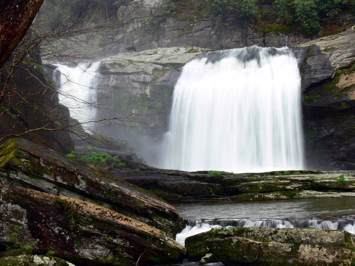
Compression Falls (Photo by Dave Aldridge March 2012)
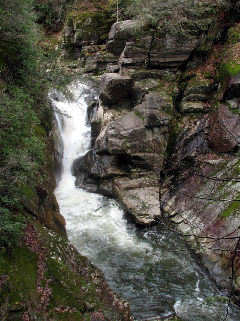
Twisting Falls (Photo by RAT April 3, 2012)
The week prior to this trip, Dave Aldridge and Bol’Dar had gone to the Compression Falls without me as I was unable to go that week so, I opted to bypass them on this trip and seek the Twisting Falls instead. Besides, I can easily go to Compression Falls anytime like everyone and their brother does each weekend ! We were also interested in a new waterfall that Dave had discovered the week earlier that was seen way off in the distance on the other side of the river high above the Twisting Falls. He happened to see water in the trees and used his zoom lens to get a view of a small part of them. They seem to be well over 200 feet high with parts that free fall plunge farther than you can see. We hoped we could find these feeder falls as there is no information about them that we could find.
Top portion of the 'Mystery Falls' as seen across the Elk River Gorge

Zoomed shot of upper portion of the 'Mystery Falls' (this is at least 100' plunge, photo by Dave Aldridge)
After driving to the trail head for Compression Falls, we parked at the old barn there and took the forest road that goes straight ahead (instead of going down the STEEP trail to the Compression Falls) that eventually leads 5 + miles to Elk River Falls. In a short time you will find a trail dropping sharply off the right side that leads down the STEEP hill towards the river. Dave showed me the mystery falls and I was mesmerized by them. I guess I now have a new ‘quest’. The top part where the long free fall plunge is, comes right out of thick laurels far away as it drops off the top of the mountain located across the river but, it seems to have two more parts that stair step down until it finally reaches the river which would make the total height of these falls to exceed 400 feet. The trail was very well traveled so there are plenty of people who know how to get down to the Twisting Falls vicinity. I am also told that some rafters use this trail as a ‘portage’ around Twisting Falls instead of roping them across the rock cliffs but, I can`t imagine packing a kayak up that hill. It only took a few minutes to reach the bottom and the first thing I could see was the awesome lower part of the mystery feeder falls where it meets the river. The sun was too bright for good pics but I enjoyed seeing these falls immensely.

Mystery Falls (Photo by Dave Aldridge)

Lower part of the 'Mystery (feeder) Falls'
The trail ended at the Elk River on a long, flat, beach-like area and it was quickly apparent that we were just above the Twisting Falls. A glance down the river revealed what I call the ‘Wasp’s Head Rock‘ that sits high above the actual falls where the portage is. The kayakers actually rope their boats across the narrow ledge that sits just under this very unique triangle shaped rock. I can`t help but wonder how it got that shape. First we would check out the mystery falls before exploring down river to see if we could get to the Twisting Falls. The water levels were up so there would be no going down the side of the river and due to the slanted rock sides and laurels I do not think it would be possible anyway.

Looking down river towards the top of Twisting Falls

Slanted rocks near the top of Twisting Falls
After checking out the mystery feeder falls and surrounding area, I proceeded down river photographing the various shelf falls and looking for a way to get down to the Twisting Falls. You could see the top of them dropping off the edge of the world just below us but getting there without crossing the river would be tricky. I found a small ninja trail hidden in the laurels (as ninja trails tend to be) and made my way around and down to the next and largest set of shelf falls (ones I have seen videos of people jumping in from) and it wasn’t long before I found myself able to get out on the large slanted rock where I seen the ‘rectangle rock‘ earlier. This gave me a good view of the ‘Wasp Head Rock’ and the surrounding cliffs. It was too risky to venture out to the top of the falls. I could see Dave still back at the mystery falls taking pics so I had to backtrack some to get his attention and coax him into following me. From there the ninja trail continued higher and higher becoming quite narrow in places and skirting above and below huge, super steep rock cliffs. This was definitely some of the steepest and roughest terrain I had been on in a long time.

Looking down at one of the larger 'shelf falls' from above on the ninja trail

Left side of the 'shelf falls' as seen from closer up

Right side of 'shelf falls' as seen from closer up (many videos are online of people diving into this swimming hole)
After carefully climbing across the steep side hill above the sharp drop offs and under other rocky cliffs, we eventually came out on top of a tall cliff well above the top of the falls. There are numerous rock obstacles that one must find a way above or below to get by. There was a huge ravine that Dave called ‘The Grand Canyon’ that we had to find a way around the top part of in order to continue on if we were to have any hopes of getting a view of the falls. Of course getting a view from down at water level would require going down the ravine which we opted to save for another time. Dave waited on top of the cliff while I found the way over and once I got the view of the falls from the sweet spot I went back and got him.

Dave feeling a bit uneasy after negotiating the terrain seen behind him !
This was a rather risky venture as one slip here could mean certain and serious injury but I knew it was within Dave`s capability and soon we were sitting in the sweet spot with our tripods setup, taking pics of the Twisting Falls from a cliff perched high above them. This was an angle I had never seen a picture taken from before. I could even see the permanent ropes left there that are used by rafters to ‘portage’ their boats around and by swimmers to climb back up the rocks after diving) This was worth all of the effort although I still wanted to get down to the water level for a close up shot but, I am sure I will do that later when I come back to show all this to Bol’Dar. (He is really going to love this place)

Looking over the 'rectangle rock' near the top of Twisting Falls

Dave looking down into the ravine as we made our way above and below the towering rock cliffs

View of Twisting Falls from high above them (Note: this is zoomed some)
This spot was very awesome and we remained there taking pics and eating our lunch for as long as we could but it soon became time to move on. We had to decide whether to go back the way we came or continue on this ninja trail and find another way back to the road far above us where we had started. I voted to continue on as I hate backtracking and I wanted to know where this trace of a trail led to. Dave was not in a hurry to go back either so we packed up and continued following this treacherous little trail which led in and round more rock cliffs and continued to gain more elevation.

Twisting Falls

Twisting Falls

Twisting Falls

Twisting Falls
From there the trail more or less disintegrated but I was sure if one was to follow in the direction it was going and fight your way through the growth and rocky terrain that it would eventually come out in the draw beneath the power lines and maybe even over to the trail that leads down to the Compression Falls, but I seen no signs of recent travel in that direction and looking up, it seemed doable to climb up and follow the ridge to the road we knew was up top above us.

Compression Falls as seen from high above

Compression Falls as seen from high above
Compression Falls as seen from high above
There was some blue flagging going that direction but there was easier ways to make our way to the top but I kept seeing them as I switched back each time.There was more large rocky areas that we had to maneuver around but it was no trouble and it got easier as we continued climbing higher towards the top. It was steep and it had become quite warm and the sun was baking us as we huffed and puffed our way up the steep ridge but soon enough we started seeing trash and signs of being close to the road (including a refrigerator door) and then there it was. We came out in the curve of the road not far from the trail we had taken down. I could actually see it from there. I made it up first and was glad to finally be on level ground again. I waited on Dave to finish his climb and then we both made our way back the short distance to our vehicle. We decided that neither of us had the energy to go down to the Compression Falls and back so I will have to do that another time. We decided instead to go by what is called ‘Trashcan Falls’ on our way home. When we got back to the vehicle, we met a nice, older guy, a local who we had some good conversation with before we departed on our way.

Some of the rocky areas we had to climb around on our way back to the top

Looking back at Compression Falls as we started climbing up the ridge

Blue flagging found along the ridge

Old barn found at the trail head of Compression Falls
It was a nice scenic drive from there over to highway 321 where we parked at the trail head for the Trashcan Falls. You can actually see these falls from the road so it is a very short walk up to them. I am told they got their name due to there used to be trash dumpsters on the road right there at the trail that leads to the falls, hence they were known as ‘Trashcan Falls’. The dumpsters are no longer there. I can not believe I have driven by these falls for so many years and never even knew they were there. They are very nice and as one makes his way up past each level of them you realize there is much more of them on the top part where a large pool resides just before it starts dropping down the multi-level falls before going through a large tunnel under the highway where it then spills into the Watauga River. This is apparently a favorite swimming hole for the locals and there is a very nice campsite just on the other side.

Trashcan Falls

Trashcan Falls

Trashcan Falls

Trashcan Falls

Trashcan Falls

Dave standing on upper part of Trashcan Falls
I took what pics I could despite the very bright sun as we started at the bottom and worked our way to the top. I will definitely have to come back here on a more cloudy day to get any decent shots of these falls. By the time we got to the top part of the falls, we were very hot and was ready for something cold to drink besides the water we were carrying. We hiked the short trail back down to the vehicle and proceeded down the road to the next local country store. A nice cold drink made the drive home more enjoyable. We arrived home well before dark. I can’t wait until our next adventure.
For more pics of all these waterfalls, please visit our Photo Gallery here.

 My name is 'RAT' and I love the mountains and waterfalls of the East TN. area where I live and I hope you enjoy this blog about my outdoor adventures.


3 Comments to “Twisting AND Compression Falls – 4-3-2012”