


Devil Fork Falls and Rocky Fork 10-19-2010
It has been several months since I have been on what I consider a truly awesome adventure (Buckeye Falls in March of 2010 comes to mind) but, this past week has fulfilled that quest. I had been out taking pics of the Fall colors the weekend before and ended up in the Devil Fork area looking for the waterfalls there. Not to be confused with the Devil’s Fork Falls in the Sampson Mtn. Wilderness area, but the one on SR 352 that leads to Devil Fork Gap where the Appalachian Trail crosses. I had found several awesome cascades that weekend but fell just short of the actual Devil Fork Falls. This prompted me to come back there as soon as possible, so on 10-19-2010, my friend Bol’Dar and myself did just that. After our usual late morning start of around 10 a.m., we arrived on Devil Fork Road (SR 352) about 11 a.m. or so. Parking at the water supply access road, (about 1500 feet from the beginning of the road) we then walked farther up the paved road about 500 feet or so to where you can see the falls below the left side of the highway. This is where I left off last time beside the hornets nest, so we went down the bank there which leads right to the falls.
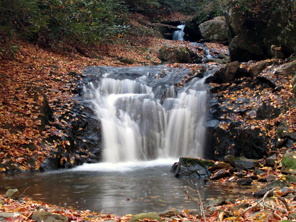
Devil Fork Falls (lower)
Devil Fork Falls (upper)
Despite low water levels, the falls were very nice and the light was not too bad. We spent some time enjoying the area around what is known as the lower and upper falls, but decided to venture further upstream on our way out. Low and behold, just around the next corner was another set of falls, each larger than either of the previous two that are listed for this area. One was actually a ‘double falls‘ which was very nice. It made me wonder why these falls are not listed on the Tennessee Landforms directory as they are both larger and nicer than the ones that are listed. We took time to take some pics, explore the area, and eat a snack before climbing up to the road to walk back to our vehicle. This was a fine discovery making a pleasant reward for my second trip to these falls.

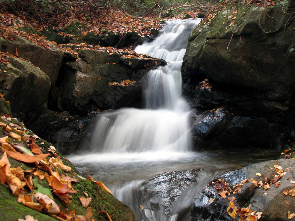
Devil Fork Falls (found above upper falls)

Devil Fork Falls (second set found above upper falls)
From here we went around the corner to Rocky Fork, parked at the gate, and proceeded up the old familiar road. It has been several years since I hiked anywhere in Rocky Fork but the memories of many trips here over the years came flooding back instantly.There are several nice cascades along Rocky Fork Creek.

Rocky Fork Cascades

Cascades along Rocky Fork Creek
We spent a few years exploring most all of this vast wilderness-like area in the past, but we had never ventured to find the top of what we call ‘Stonehenge‘ which we recently learned was called Whitehouse Cliffs on the North slope of Whitehouse Mtn. I knew after seeing the monumental rocks looming at me from a distance last weekend, that I would be coming back here soon. We reached the base of the towering rocks after a half a mile or less, but you really can’t get a good visual on them from there however, there is an impressive set of cliffs just across the creek from them which I am sure used to be part of the same formation a long time ago.We would be looking right over at these later on that day.

Base of cliffs in Rocky Fork
Not too far beyond the cliffs there is an old road trail that leads off into the first main hollow to the right. It is not well traveled but not so overgrown that you can not make your way up it. I actually found it a very enjoyable route to hike. It climbs steadily but gently up and around to the right making its way around the left side of Whitehouse Mountain. The leaf colors were still gorgeous but it was another extremely sunny day so getting any quality pics was doubtful, although what my eyes were seeing would be unforgettable.

Fall colors in Rocky Fork
We continued to follow this trail until it eventually came to a saddle where another trail came in from the left. We knew this was not the way to go, so we veered slightly to the right, following the trail that continues upwards towards the gap behind Whitehouse Mountain that we could now begin to see. This trail was still not bad even when it overlapped a dried up rocky creek bed for a short distance. Looking back, you can see where it started and stopped. It did not take long before we could see the gap right above us and in a few minutes we were there. There was a prominent trail that continued straight ahead down into the next hollow which according to the map would lead back to Rocky Fork Road,,,eventually.

Bol'Dar hiking towards the gap
There was a faint trail to the left going in the direction of Wilson Knob but we knew we were definitely not going that way ! Looking back we could see the elevation we had gained already. Our destination would be to the right where there was an even fainter and basically nonexistent trail up the ridge. We advanced in that direction climbing at first and more or less bushwhacking our way, but after seeing another prominent ridge joining in from the left, we started veering left, traversing the hill instead of climbing it, and within a short distance we came out on that ridge where there was a red blazed boundary trail leading straight up towards the summit of Whitehouse Mountain ! It was steep, but freshly cleared and marked with blood red blazes and boundary signs being direct and to the point of where we wanted to go.

RAT on the boundary ridge trail
As we climbed higher and higher up this killer ridge trail, we couldn’t help but notice the knob over from us. It had looked like just a small hill from the saddle and the gap we were at on the way up, but was now beginning to loom higher and higher with that ‘volcano-like’ look to it. It was covered with magnificently colorful trees and kept looking larger and larger as we climbed higher. It was quite impressive. We were also starting to get a view of Frozen Knob and Higgins Ridge.

View of 'volcano-like' knob with Wilson and Frozen Knobs on either side
It was becoming apparent that there was going to be some unbelievable views on top of this thing. Continuing upwards, we reached what we thought was the summit but turned out to be a false summit as it went over and up again. As we neared the top, the terrain became rocky and it was obvious that this had burned sometime in the last year or so.The sun was now directly in front of us blinding our camera lenses. I did capture a few neat effects of ‘Bol’Dar‘ atop a large rock formation.

False Summit
It was about that time when we came to the survey marker and boundary marker signs. It did not have the elevation on it but according to the map we were at around 3,300 feet. This doesn’t sound very high, but the views from the vantage point on top made it seem like you were on top of the world.

View looking back towards Erwin
The sides of this narrow ridge are incredibly steep. Just as we neared the top, there were some blow-downs that forced us to the left side of the ridge where I got my first view in that direction. I was looking right over and down at the Flagpond Exit Visitor Center on I-26 and could see all the way back to Erwin and beyond. A few more feet and I could look over and see Big Bald and Little Bald right over from us. (Zoomed view of Big Bald can reveal the actual bald) This inspired me to climb faster and soon I was standing on the highest point of this mountain. It was clear of any trees and very rocky with the most incredible views I have had in a long time.

Rocky Summit of Whitehouse Mountain
It is not just the view that makes this place spectacular, but it is what you are able to see that makes it very special. It is a 360 degree panorama of everything from Sams Gap panning right to Hogback Ridge, all of Flint Mountain, Flint Gap, Snakeden Ridge , Coldspring Mountain, Big Rocks, Big Butte, The Ball Ground, Buzzard Roost, Wilson Knob, Frozen Knob, Higgins Ridge, (more of Higgins Ridge), Temple Hill, No Business Knob, Unaka Mountain, Flattop Mountain, Spivey Gap, Little Bald, Big Bald all the way over past Street Gap back to Sam’s Gap. This was one unreal place to be for sure, I was in awe.

RAT and Bol'Dar on the summit of Whitehouse Mtn.
Just below us you could see the drop off where we knew the top of the cliffs were but, Bol’Dar had left his hiking stick somewhere on the ridge we came up, so we kinda had to go back that way. We opted to come back and go down to the cliffs and find a way out that way on another trip, as it was a given that we would be coming back here soon. You could see the cliffs across from us very good from here. They are larger than I first thought.Taking any quality pics was nearly impossible due to the intensely bright sun that was shining right in our faces. Just another reason for a return trip. I took plenty of shots anyway as the views and colors were mesmerizing and I also wanted some topo views for future map studies.

Looking over Rocky Fork with Coldspring Mtn. and A.T. in distance
We ate our lunch on the summit spending as much time as we could in this incredible place before descending back down the red-blazed ridge trail (not wanting to be there in the dark and the sun was setting fast). It did not take long at all to find Bol’Dar’s hiking stick and before long we were back to the turn off where the bushwhack over to the gap begins. Going down was much easier and the setting sun made the red colors much more brilliant. Before we knew it we were back to the end of the old forest road trail where a large toad was waiting to tell us farewell. I assured it that we would be back soon and then continued on to the main road and back to the vehicle. It was already getting dark and the nearly full moon was out. What a fitting end to a perfect day of hiking to some remarkable places.

To see all photos of the cascades and falls found along Devil Fork Creek, please visit the Photo Gallery HERE.

 My name is 'RAT' and I love the mountains and waterfalls of the East TN. area where I live and I hope you enjoy this blog about my outdoor adventures.


Leave a Comment