


Upper Dick Creek Falls – 3-3-2012
I have been going to the Dick Creek area for well over 30 years now and recall many trips there for off-roading, hunting, camping, and to visit the Dick Creek Falls (lower) which I think is one of the prettiest waterfalls in East Tennessee. Back then we called it ‘Dixie Creek’. I have heard many times of an Upper Dick Creek Falls and despite deer hunting in that hollow many times, I had never seen any significant waterfalls there. Of course back then I was not looking for waterfalls. After recently seeing a picture of the upper falls and hearing of many failed attempts by others to find them, I took it as a challenge to myself and my friend Bol’Dar to locate these elusive falls once and for all. This was accomplished on a Saturday, March 3, 2012.

Upper Dick Creek Falls
We chose to start at the Rock Creek Park Area which was still closed for winter and also due to removal of hazard trees. (There was quite a mess there from that). This is the longer and more difficult route to get to Dick Creek as it requires climbing uphill on the Rattlesnake Ridge Trail to Dick Creek Gap and then downhill on an old forest road to Dick Creek and up to the falls. This means you will be going uphill both ways ! There is a shorter and more level route which I actually prefer going in to Dick Creek from the Limestone Cove side which I consider to be much easier but, I was needing some exercise so I did not mind going the uphill way on this day. We left Hairnt-Quarters around 9:30 am and were making our way across the Rock Creek park before 10:30am. The gate being closed does add some extra distance but the park is level and easy hiking.

Gnarly Tree in Rock Creek Park
Once you reach the back end of the park you will find the trail-head for the Rattlesnake Ridge Trail leading across the creek on a wooden bridge. This follows a small creek until the trail gains elevation and begins the climb up to Dick Creek Gap. It is a narrow but nice trail with some switchbacks and was recently part of a controlled burn so it does not take long to reach the gap. This is a perfect place to ‘snack early and snack often’ as we like to do so we enjoyed a relaxing rest beside a large mud hole full of tadpoles. After this we said goodbye to the Rattlesnake Ridge Trail and descended down the hill on the old forest road that leads to Dick Creek.

View from the Rattlesnake Ridge Trail (looking back towards Unaka Mtns and Rock Cr. Park)

Old stump along the Rattlesnake Ridge Trail
Of course this is the easy part and in no time you find yourself at the bottom in the Dick Creek Valley. The trail soon becomes a waterway for the many creeks that flow into the valley and this will lead you to the actual Dick Creek where you will cross it just before reaching the main forest road where you will go to the right. It is not far from there to reach the Lower Dick Creek Falls where we discovered someone had cut the growth out to make a road that people have been driving on all the way to the falls where a large campsite has been cleared right at the top of the falls. This was somewhat disturbing. There was a primitive table built on a tree there and some trash in the area. We even found what we called a ‘redneck blue-blaze‘ ! We did not spend much time there as our main goal was to find the upper falls so we followed the creek trail (you can take the road instead if you wish) that leads over to the largest campsite beside the grassy field where we used to camp at so many years ago. There was even more trash there along with lots of damage to the field done by off road vehicles.

Looking down on the Lower Dick Creek Falls

Bol'Dar`s shadow trying to have a beer !
Knowing that the upper falls are a ways upstream from there, we continued onward, anxious to see if there was any kind of trail leading up the creek. The road goes beyond the field a ways where it crosses the creek and more or less dead ends at a camp site although many years ago it continued well beyond there and used to have a gate just on the other side of the creek crossing. There was no visible trail on the left side of the creek so we crossed the creek to the large opening at the camp site there to rest and study the maps. This is where it gets tricky as there are no visible trails leading upstream from this point. Keyword being ‘visible’ as many times there are hidden trails or remnants of old trails hiding just beyond sight. With this in mind we decided to cross back over the creek and make our way through the heavy growth on the left side to see what was there. There was a faint old trail there but it was all but gone and after fighting our way through the laurels and growth we found ourselves high above the creek at a large rock where we had to climb down to creek level near a vertical dirt bank on the left where the hill had caved in which forced us into and across the creek to the right side.

Old stump found along the high ridge trail on the way to the upper falls
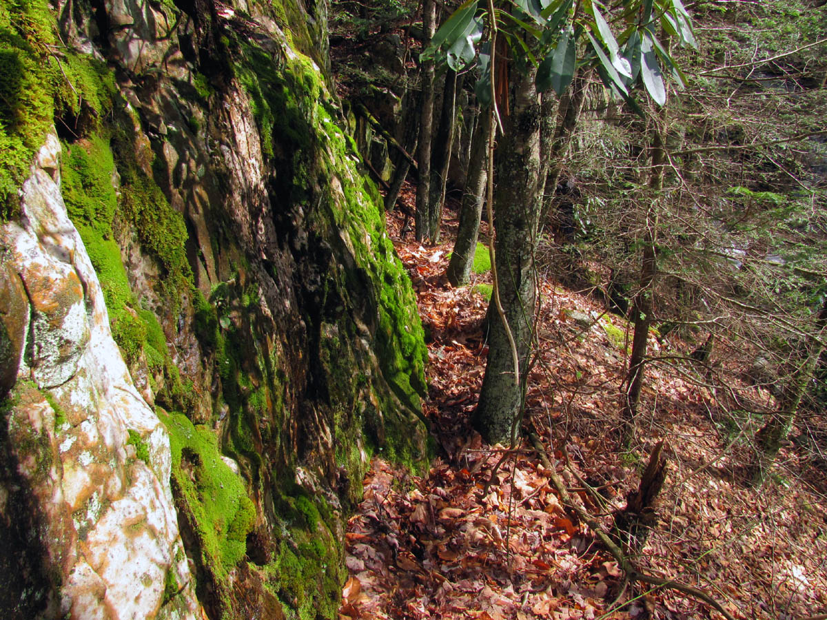
There we could see above us (on the right side of the creek) a large saddle leading into the valley so we followed it on a fairly good trail for a ways until it appeared to also disappear into the creek and laurel hells. There is no way to simply follow the creek as it is nothing but solid laurels that are impassable. We also noticed we were getting higher above the creek and could then see an even higher ridge on the other side (left side) that looked very good if only we could get there. Unfortunately crossing the creek and climbing up there was not feasible at any point due to the laurels and sheer steepness of it so this left only one choice which was to go back and try and find where that ridge began and cross over to it. This was also easier said than done but after two trips up and back and checking out a false hollow on the other side of it, we ended up just above the vertical dirt bank where we had started and found the point of the ridge we were looking for. Crossing the creek there and going through a very short but sweet laurel patch, we found a small (but steep) rise where we climbed up to it and discovered a very nice open ridge on the left side of the creek. This was the one we were looking for that we had seen from the other side. We proceeded to follow this which quickly gained a lot of height above the creek just as we had seen from the other side.

Looking down on Dick Creek from high above on the left side ridge trail
The left ridge is mostly open and was actually very pleasant to hike on with hardly any obstacles. It keeps gaining elevation slightly as it follows high above the creek. We could hear and barely see several of what seemed to be very large cascades down below that will be fun to explore at a later time. Since it is only just over a half a mile or so from the road to the upper falls, it was not long before we spotted a rocky area ahead and as we approached them I saw my first glimpse of what I knew was the falls. They were much larger than what I had anticipated from the two pictures I had seen of them. I found a nice little ninja trail that went just below the rocks leading down to the base of the falls. This was a place of incredible beauty and we were jubilant to finally be there.
Ninja trail that leads down to the upper falls

Following the ninja trail down to the upper falls

lower part of the ninja trail almost to the base of the upper falls

Standing at the base of the upper falls
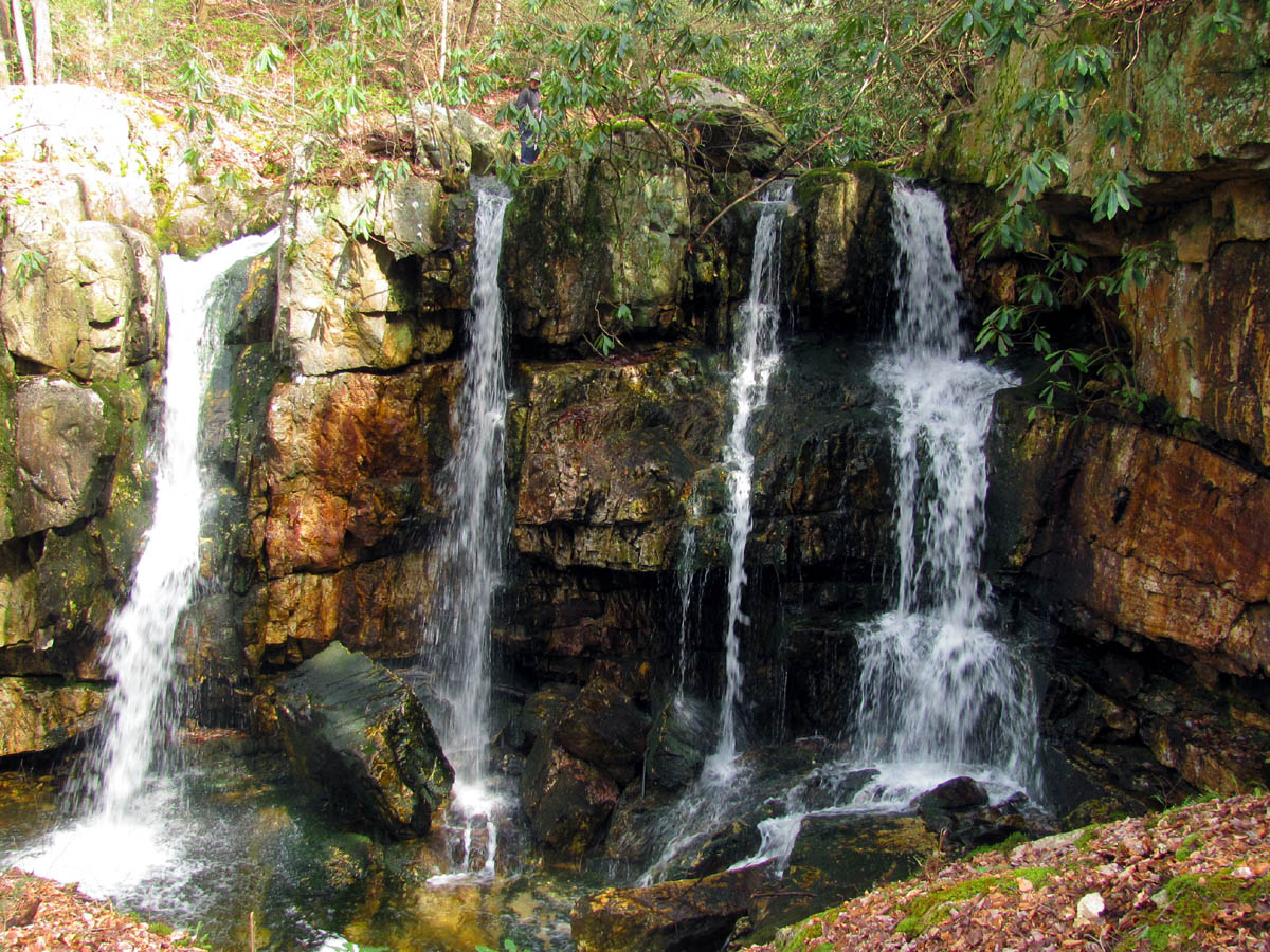
These falls are amazing and what I call ‘bonus falls’ because they are like getting four waterfalls in one, each of which can be photographed separately and each would still look awesome all by itself. They seemed to be about 35 to 40 feet tall and the colors of the rocks there are vivid and different than anything I have seen before. It was a warm and sunny day so it was hard to get any special pics and the sun was shining directly on the left side yet shaded on the right which also made it hard for a novice camera to photograph. I am sure I will be back here soon and hopefully on a cloudier day while the water levels are still up. We spent some time here enjoying the alluring beauty while making our way slowly over to the right side taking lots of photo`s as we went along.

Upper Dick Creek Falls

Upper Dick Creek Falls

Upper Dick Creek Falls

Upper Dick Creek Falls
There are some HUGE rock slabs that have apparently broken off the right side and fell down into the bottom of the falls most likely from the creek eroding underneath them over the years. From the discoloration of the rock walls above them, it has not been that long ago since this happened. These make a perfect stage to stand on to view the falls. After hanging out on them for quite a while, we found a way to climb up the right side to get on that level which leads easily to the top of the falls. This short climb was a difficult one and not recommended for everyone but it is easy to go back the way you came on the left side and continue up the left ridge to the top of the falls instead and not risk being injured in such an inaccessible place.

Left side of Upper Dick Creek Falls

Left side of Upper Dick Creek Falls
Upper Dick Creek Falls (find Bol'Dar)

Right side of Upper Dick Creek Falls
There were a series of springs coming down the right side making small falls which were a pleasure to see. I am assuming these dry up in the summer months. After the tricky climb up beside those, it was indeed easy to get around to the top of the falls where I crossed the creek and found a couple more small falls just upstream. One of these had a large pool with a bottom of gold. I have not seen a more yellow color ever before. We also discovered that one of the main falls forms what I call a corkscrew just before it goes over the edge of the falls. This was very cool and I tried to get some good pics but the bright sun made this impossible.

Smalls falls and gold pool at top of Upper Dick Creek Falls

Small falls and gold pool just above Upper Dick Creek Falls
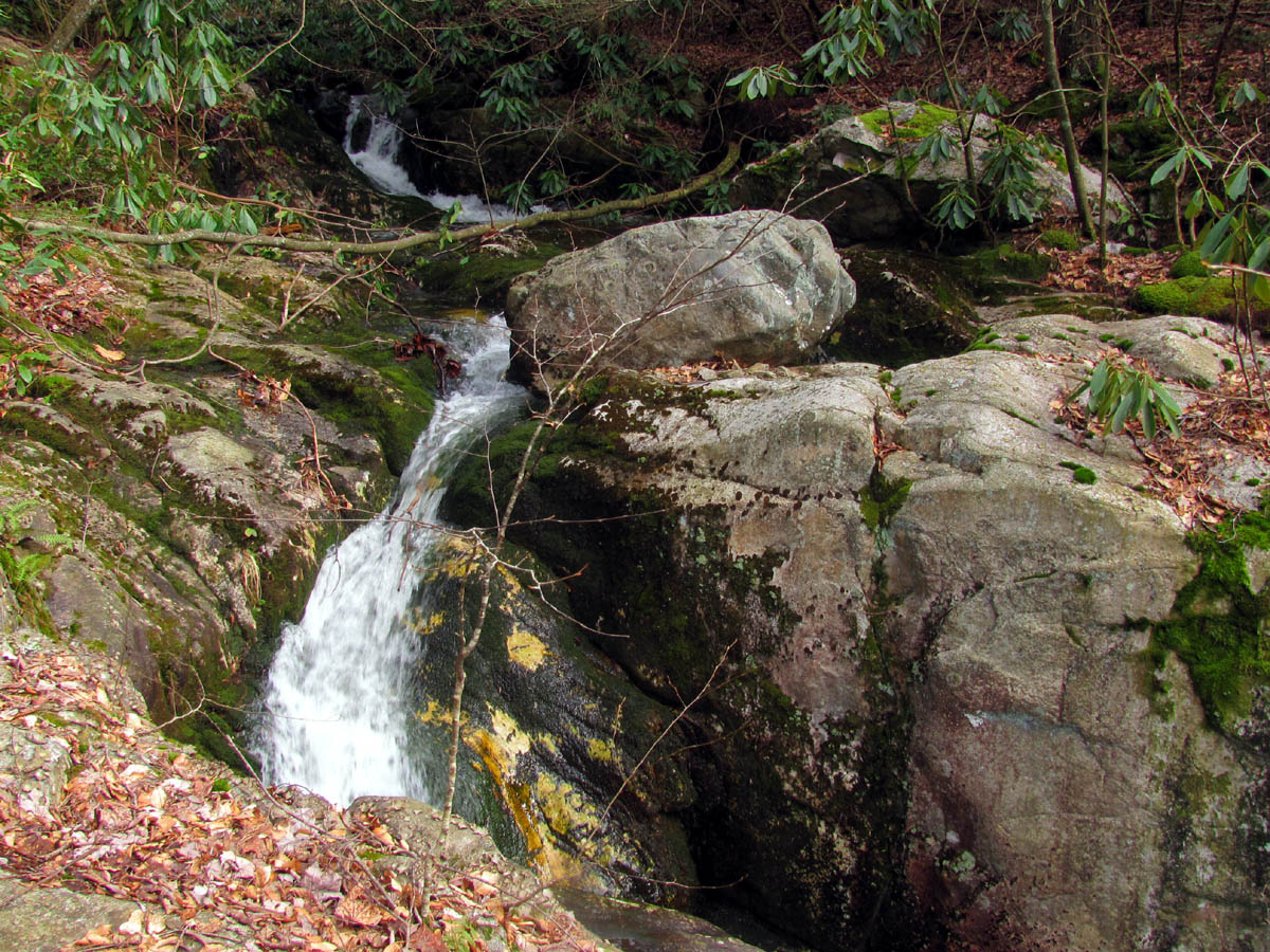
Dick Creek just above top of upper falls as it goes into 'the corkscrew'

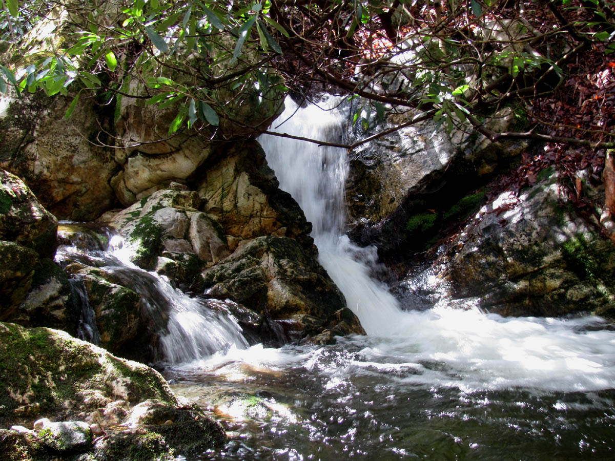
The 'corkscrew' part of the Upper Dick Creek Falls

The 'corkscrew' part of the Upper Dick Creek Falls

Side view of part of the Upper Dick Creek Falls from the top
There is a large flat spot on the solid rock top of the falls where we hung out and ate our lunch looking out from the top of the falls. Truly an amazing place of seductive beauty that I am sure to come back to often now that it has been discovered. This is another one of those places that I am glad there are not any perfect trails or easy visible access as it limits the traffic and impact on such a pristine place. There was little if any sign of man, no trash whatsoever, which is rare. So many waterfalls are affected by those few who do not respect Nature and think they can just leave their trash there instead of leaving it the way they found it for others to enjoy.

Bol'Dar atop the Upper Dick Creek Falls

Upper Dick Creek Falls

Upper Dick Creek Falls

Upper Dick Creek Falls
We stayed as long as we could but eventually we knew we had to leave since we still had to not only hike back out of there but we also wanted to stop for a bit at the Lower Dick Creek Falls and then there was that long hill to climb back up and over, not to mention going back down and then out the park. Going back the way we came only this time above the rocks instead of below them, we made good time down the ridge and were back at the creek crossing in just a few minutes where we crossed and followed the other side and came out on a hidden ninja trail that quickly led right to the large open turnaround just across the creek at the end of the road where we had started. Too bad we did not find that then ! We crossed the creek and hiked back down the old forest road back to the field and the large camping spot where we got back on the creek trail which we took over to the lower falls.

Lower Dick Creek Falls

Lower Dick Creek Falls

Lower Dick Creek Falls

Lower Dick Creek Falls
There are some really nice falls hidden back in the laurels just above the top of the Lower Dick Creek Falls so we climbed down in there to check them out and get some pics before moving down to the lower falls. I love these small falls and they are proof that size does not always matter.

Small falls located just above the top of the Lower Dick Creek Falls

Small falls located just above the top of the Lower Dick Creek Falls
Small falls located just above the top of the Lower Dick Creek Falls
The lower falls are in my opinion one of the prettiest falls in East Tennessee. The colors of the rocks and surrounding plant life are very unique and are a real pleasure to photograph. We spent awhile here taking in the awesomeness of this exquisite place before moving on down the road back towards ‘the hill’.

Switchback on the Rattlesnake Ridge Trail

Rattlesnake Ridge Trail

Swimming pond in Rock Creek Park

Bridge and small cascades at upper end of swimming pond (Rock Creek Park)
Back down the road to the turnoff and across the creek , the watery road leading towards the hill did not seem bad for the first part but, the last part makes up for it as it seems to go on and upwards forever. I was dragging along pretty slowly until I finally caught up with Bol’Dar at the gap. We took a break there to rest up and reflect on the awesome upper falls we had found earlier. The sun was starting to set so it was soon time to move on. At least it would be all downhill from there. After a short while we were at the bottom and walking back through the park and decided to check out the swimming hole pond. I love the reflections that can be photographed there. A few minutes from there and we were back to the gate and vehicle, this time before dark. Another killer day in the woods with a great discovery. I am sure I will be back soon.
For more pics of the Upper Dick Creek Falls, please visit our Gallery here. To see the Lower Dick Creek Falls , please go here.

 My name is 'RAT' and I love the mountains and waterfalls of the East TN. area where I live and I hope you enjoy this blog about my outdoor adventures.


One Comment to “Upper Dick Creek Falls – 3-3-2012”