Archive for November, 2012
Ever since my waterfall crazy friend Dave Aldridge took me to see Little Lost Cove Creek Falls (North Carolina) back on July 5, 2012, I had wanted to go back and walk the old road trail above them down to the Lost Cove Creek to see where it came out at. Dave had been looking at that area on his Google Earth and thought he saw the whitewater of some waterfalls on Lost Cove Creek near the end of that road and contacted me to see if I was interested in going on a short hike there, so on September 27, 2012, Dave, my girlfriend Linda, and myself, went to the Little Lost Cove Creek area and followed that old forest road past the turnoff to the Little Lost Cove Creek Falls until it eventually ended at the Lost Cove Creek in the valley below. This is about a 2 mile hike on a very nice old road trail so it did not take long to reach the bottom where it intersects with Trail 262 that follows the Lost Cove Creek all the way down past Huntfish Falls to where it enters into the Gragg Prong Creek. That trail also loops to Roseboro via the Timber Ridge Trail. Once we reached this trail intersection, we took Trail 262 downstream for a short distance until we found the gps point Dave was looking for. It seems the whitewater he had seen was not a falls at all but a small cascade ! It was really not worth the effort to walk down there and back but then again, it was just a short hike to get a little exercise and besides, any day in the woods is a good day right? Plus, now I know where that road goes to and I found where the Lost Cove Creek Trail (262) crosses the creek there and heads up to Timber Ridge to get to Roseboro. I want to do that loop one day. I also scouted out another trail at the intersection that leads back towards the ridge in the direction of the Big Lost Cove Cliffs and upstream on the Lost Cove Creek which I also want to further investigate as I am sure I seen some nice falls with a large pool there on the Google Earth map. Linda found a small garter snake laying in the trail before we got to the cascades which was the highlight of the trip.The weather was great and we stopped for BBQ at the Highlander in Roan Mountain on the way home.

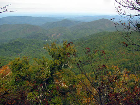
Old forest road trail that leads down through the Little Lost Cove Creek Valley to the Lost Cove Creek / Valley
(more…)
Posted on 29 November '12 by RAT, under RATtreks. 2 Comments.
I was recently contacted by my friend and fellow trail maintainer Doug Corkhill, and informed that he was planning a work trip to Big Bald to work on his trail section. We had both been invited earlier in the month of September by the Trail Supervisor, Tim Carrigan and long time trail worker and former Trail Supervisor and engineer extraordinaire, Howard McDonald, to go in with them but they ended up canceling so Doug said we would go anyway. On Tuesday, September 25th, we met at the trail head to my section at Spivey Gap where I left my car and rode with Doug (who goes out of his way to drive to Spivey Gap to pick me up) to Big Bald. We obtained a key to the gate and drove to the grasslands below the bald and down the old road to near the shelter. My girlfriend Linda went with us and helped me paint all the blazes on my entire section which is over 5 miles long. We first had to hike to the shelter (The Carolina Condo) where we met a nice local couple who had been out hiking for about a week. From there we continued on the ridge the 2 miles out to the top of Little Bald (aka Big Hairy, aka El Grande Chi Chi) where my section start/ends. Doug accompanied us to that point where we all had lunch and then he went back the way he had come to work his section on the way back to Big Bald.
View from TN side of Little Bald summit looking towards No Business Knob, Temple Hill, with Erwin and Johnson City in distance
(more…)
Posted on 28 November '12 by RAT, under RATtreks. No Comments.
This years adventure found us hiking along 25+ miles of the Mountains To Sea Trail high in the mountains of North Carolina. Starting on the day after my birthday, September 9, we began our journey by driving to the Upper Creek area on NC highway 181 that leads between Pineola and Morganton. My plan was to start at Beacon Heights on the Blue Ridge Parkway and come out some 25 trail miles later on highway 181 but, the dilemma was that I felt it was not the best idea to leave a car parked along the side of the road for 5 days or so. To combat this issue, I contacted Kate Dixon who is the executive director of the Friends of the Mountains to Sea Trail foundation and she replied back to me almost immediately with some people to contact that could help me out. This would be Doug Veazey who put me in touch with Bob Benner, both of which are longtime trail maintainers who were able to help us out tremendously. They were happy to help us as fellow trail maintainers for the Carolina Mountain Club and Bob found us a great location to park my car behind a gate in a gated community located near to where we would be coming out at, and also volunteered to meet us there and give us a ride to Beacon Heights to start our hike. I can`t say enough about all these wonderful folks who went out of their way to help us. Since Bob is more or less the trail boss over this entire section of trail and then some, and since it was such a beautiful hike the entire way, we made many daily references to the old ‘Blues Brothers’ movie by saying many times: “Beautiful place ya got here Bob ! “.
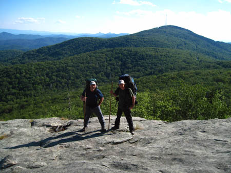
RAT and Bol’Dar at Beacon Heights
(more…)
Posted on 22 November '12 by RAT, under RATtreks. 1 Comment.


 My name is 'RAT' and I love the mountains and waterfalls of the East TN. area where I live and I hope you enjoy this blog about my outdoor adventures.


