


California Creek Falls and Cody Falls 11-20-2010
It has been many years since I abused various off road vehicles and trails in the Rich Mountain area located in Unicoi county, going to such places as Bumpass Cove and California Fields. My fellow ‘waterfaller’ friend Dave, asked me if I knew how to get to California Creek as he was interested in finding the waterfalls located there. Of course I knew the way but, it seems a friend of his, Jimmy Hilton, who was raised in the area and whose father had actually worked in the mines there, had recently shown him the best way to get there from above the upper falls. Most people risk wading across the Nolichucky River to where California Creek enters into it, and then proceed upstream past the lower falls to Cody Falls and the upper falls. We decided to start well above all of these and work our way downstream instead. This turned out to be a good idea as we ended up discovering some nice cascades and another waterfall above the upper falls that are not yet named or listed.

Falls found above upper California Creek Falls
It was another warm, sunny day and we were happy that this year the Indian Summer period was lasting much longer than usual. We met fairly early at ‘Hairnt-quarters’ taking my vehicle since a four wheel drive with higher clearance was required for the off road trip from Bumpass Cove to near Rich Mountain. There was a plethora of hunters everywhere and I am sure they did not like our presence but, that did not bother nor hinder us. After about 2 miles we parked at the destination point and proceeded behind the gate down the old forest road (Patty Ridge Trail #113) which leads to two fields known as the ‘California fields’. Somehow we missed the shortcut we were looking for which was an old road (which is now overgrown) that leads down to the upper falls on California Creek. Again, as I stated before, this turned out to be a good thing as we would have missed the cascades and falls that we discovered above the upper falls. We followed the old road down to near the creek but turned left before the lower field making our way down the valley. The California Trail (#114) is for the most part nonexistent but it is passable minus a few places where the laurel thickets have taken over. It is hard to imagine that there was actually a road through there back when mining and logging was going on, but there are remnants of equipment, cables and graded roads (now overgrown) that tell the story of what went on there many years ago.

First cascades found above upper falls

Second set of cascades found above upper falls
Traveling down the valley, taking the path of least resistance yet staying as close to the creek as possible, the first thing we came across was a nice, small cascade. Soon after there was a second set. A little further beyond these I could hear water falling so I made my way through the rocks and thick laurels and we soon discovered a very nice waterfall tucked way back in a rocky grotto. These were every bit as tall as the upper California Creek Falls and every bit as awesome if not more so.

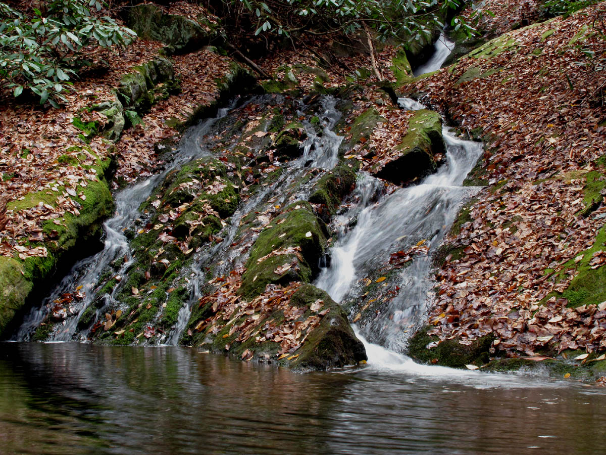
New falls we found above the upper falls
There were more cascades below the new discovery, and after about a half mile from the old road where we started down the creek, we came to the upper California Creek Falls. These falls are about ten feet in height and despite lower water levels they were still very enjoyable. We hung out there taking pics before moving further down the creek.

Cascades found above upper falls

Upper California Creek Falls
We came across parts of the old trail that still had the yellow diamond markers on the trees and, there were some fresh tracks visible so apparently there are some who make the trip from the river up to the upper falls and back. The next thing we came across was a large boulder-garden. It continued for quite a ways but was passable and actually kind of nice visually.There were also several nice rocky overlooks above us that long to be explored at a later time. It was just after this that we found an old gas tank, a radiator support bracket, a steel cable, and a rusty bucket. We also noticed more piles of bear scat than we have ever seen before in one area. It seems the ‘fox grapes‘ are very abundant this year which the bears are taking advantage of but, it does cause them to ‘go’ quite often ! According to the US Forest Service there are approximately 1500 to 1800 black bears located within the Unicoi county area. There were more laurels after the boulder-garden and then a steep drop off back to the creek. We could see the valley becoming very narrow ahead, forming the usual ‘ V ‘ normally found where waterfalls begin, so we knew we were close to Cody Falls. Just before we reached the top of those falls we passed by another small cascade.

Cascades just above Cody Falls
Standing at the top of Cody Falls it was apparent that their listing of forty feet was a bit inaccurate. The top part of the falls is at least that much. The way they are laid out, you can not see all of the falls at any one time. The top part starts falling and after about forty feet enters and almost disappears into a crevice that the water has cut deeply into the rock over many years.

Looking down from the top of Cody Falls
It continues falling through the crevice at least another forty feet or more before reaching a pool at the bottom. It flows out of this pool down a long, slanted rock bed another forty feet to a much larger pool at the bottom. These are very nice falls and I would love to see them with a lot more water flowing over them. Fortunately it is not too difficult or dangerous getting around these falls to reach the bottom.

Middle part of Cody Falls

Middle part of Cody Falls
Lower part of Cody Falls

Cody Falls
We spent some time here taking pictures and eating some snacks before deciding that it was getting too late in the day to continue another half mile to the lower California Creek Falls where we would have most likely ended up having to ford the river and call for a ride as there would not be enough daylight (or energy) left to retrace our steps back to our vehicle. With this in mind we headed back the way we came. I let Dave climb up first so I could take a pic of him at the midway point to better show the height of these falls.

Cody Falls
Working our way back up the valley we soon reached the boulder-garden and since we no longer needed to stay beside the creek, we were able to locate an old forest road on the ridge to our left which although being somewhat overgrown, made travel easier for us. It was higher above the valley and this is when we seen an old axle that was used as a support for hauling heavy equipment back in the day. This soon led us back to the road where we first entered the California Creek Valley. There was still some time left before dark, so we went left which soon crosses California Creek beside a fish dam and over to the lower field where there is a nice pond. My memory instantly recalled being a passenger in a Jeep late one night many years ago which ended up driving over the edge and into the pond (as it is not visible from that angle and there were no trees growing around it at that time). I remember feeling the cold water and things from the vehicle floating all around ! All you could see was about 2 inches of the top roll bar. If I am not mistaken, our friend Chester who was following not too far behind, pulled us out.

Pond in lower California Field
The sun was sinking low so we did not stay here long before heading back up the hill on the old road we had came in on that morning. Hoping there were no deer hunters still in the woods, we decided to take a short detour up the hill to the upper field for a view, since I had not been there in over 20 years. The field is a nice place with one small pine tree in the top center and it does afford a few views of the mountain ranges around you. Of course you can see Big Bald, Unaka and Rich Mountains from there along with parts of Erwin and Bumpass Cove.

California Field
The sun was setting so we made our way back out the old forest road back to the vehicle. On the ride out you could see the moon already up over the nearby mountains. It had been another successful trip and a great day to be in the woods enjoying the beauty of Nature. Total distance traveled was just over four miles.

Moon over the ridgeline
For more photo’s of California Falls please visit our Photo Gallery by going here. For more photo’s of Cody Falls, please go here.

 My name is 'RAT' and I love the mountains and waterfalls of the East TN. area where I live and I hope you enjoy this blog about my outdoor adventures.


Leave a Comment