


Devil Fork Falls aka The Waterfall Tour – 4-3-2011
You may remember our last trip to the Devil Fork area in Clarks Creek back in Nov. 2009 when we encountered much opposition on our way in from the top due to the extensive pine bark beetle damage and the lack of foot travel there in the 20 or so years it had been since we were there. Since that time we have been researching alternative routes to get into the Devil Fork Valley, hoping to find an easier, more direct route although, we knew due to the extremely steep and treacherous terrain, it would not be an easy affair. After a few re-con trips by Bol’Dar and much map studying by the two of us, we finally decided on what we thought would be the best and safest route. This was to be determined on 4-3-2011 when we set out to test our hypothesis.
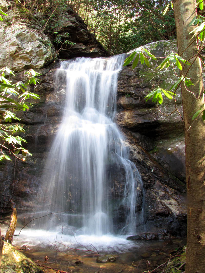
Lilybeth Falls
After a 9:30am meeting at Hairntquarters, we arrived at the Longarm Branch Trail-head around 10:00am where we left our vehicle and proceeded to walk back down the road to the Sill Branch Trail-head as we would be starting there and coming out (hopefully) at the Longarm Branch Trail later that day and preferably not in the dark as we did on our last trip here ! It was a nice morning and it did not take us long to reach the ‘Snake Head Rock‘ where the trail to the Lower Sill Branch Falls begins. We took our first break watching the morning sun shine upon the ‘MonkeyHead Rocks‘ above. (For more photos of these please visit the gallery) We climbed up on top of the Snake Head rock formation there to “snack early and snack often’ and study the maps for the next leg of the adventure. After the break was over, we continued up the South Fork of Sill Branch crossing the creek a few times over old washed out log bridges and passing by numerous cascades along the way until, we reached the yellow blazed trail to the left where we took another break. The yellow trail goes up an incredibly steep hill but is the shortest way to the old road near the top of Rich Mountain which was our destination. After a short break we began the dreaded climb. Bol’Dar led the way and I did not catch up with him until we reached the saddle about half way up where the trail comes really close to a flat part of the ridge (on our right) that we call the ‘Land Bridge‘. Bol’Dar was standing on top of it when I got there ! That was a good place for a breather before continuing on to the top. I was very relieved when I could actually see the trail marker sign on the old road up ahead of me.It was nice to finally be standing on level ground.

old Pepsi can
Looking to the left on the old road, I couldn’t help but remember the last time I was here in April of 2009 when I was looking for my lost ‘stealth pack’ on the nearby ‘MeatGrinder Ridge‘. I quickly dismissed that thought as that is a trip I kinda wish to forget. We followed the old road to the right, enjoying the views of the Sampson Mountain Range over from us and beyond to the Nolichucky Valley. Other than some downed trees, overgrowth and narrowing, the old road had not changed all that much in the many years it had been since I last walked on it. My mind was flooded with memories from those days as we made our way out the 2 miles or so to where it meets Forest Road #190 that runs the top of Rich Mountain. Walking this road is very pleasant and it was not long before we reached the first gate of the two that are near the end (actually the beginning) of the road. Not far from there is the last gate and Forest Road #190 at what we call the ‘Big R Curve’, a sharp switchback in the road where we stopped to eat lunch and study the map as now is when the real adventure part of this journey would begin.

Morel Mushroom
This is where we would have to carefully and precisely pick the correct ‘draw’ to go down, to hopefully lead us safely down into the Devil Fork Valley and come out in the right place, eliminating any cliff-like drop offs, bushwhacking, or meat-grinder type obstacles. After studying the maps very closely and walking a short distance to the right on road #190, we chose the place we thought was it. There is actually two possible ways but we chose the second one for visually ease of travel but, we quickly learned that they both come together at a really nice place where we took another short break atop a big flat rock formation in the center of the water that was flowing there between the two. Once we left road #190, we knew it would be all off trail and VERY steep downhill with no telling what kind of drop offs and oppositions until we reached the Devil Fork Valley way down below us. There was a surprising amount of water flowing down this ‘wrinkle’ in the mountain and instantly the going became extremely steep as we made our way down. Bol’Dar led the way, switch-backing to the left and then right trying to find the best and safest way down looking for the ‘path of least resistance’. The steep slope was rather open with little if any growth so other than the steepness, it was really easy to descend. Going off to our left I found myself below several large rock formations and after checking my map, I realized that not far on out that direction was the place where our friend Keplinger ran his truck off the mountain in the rain on one of our earlier expeditions here some 20+ years ago ! Another memory I am trying to forget. Being very high in elevation still, we could see views not only down into the Devil Fork Valley but also one of the prominent rock covered ridges that lead down into it as well as one of the many dense pine covered ones over from it, not to mention Big Pine Ridge and Sampson Mountain and further to the Nolichucky Valley beyond. It was rather breathtaking to say the least.

View of Pine covered ridges and further to the Nolichucky Valley
Switching back to the right took us back over to the creek where there was one cascade after another and pretty soon we discovered a really nice waterfall of at least 100 feet or more on what we would eventually learn was the main headwaters of the creek that flows through the Devil Fork Valley and helps feed all the falls there. The sun was way too bright for good pics that day but I knew I would hopefully be coming back soon to not only get better pics but to have my friend Dave along to measure the height of these falls and take a GPS reading of their location so we can name them.

New Falls found along upper Devil Fork Cr. (photo by Bol'Dar)
After the falls, the draw became steeper and narrower as we made our way down, down, down towards the bottom until eventually there was actually somewhat of an old trail beside the creek. It leveled out some at that point and soon enough we could start to see the bottom of the valley floor below us. We stopped at a nice place where some pine trees were growing beside the creek where I found Bol’Dar checking out some cascades before we came out at a large open area at the bottom where another much larger draw came in from the left and what looked like the old road and our usual way of coming in straight ahead ! It could not have worked out any better. To quote a familiar saying: “I just love it when a plan comes together” !

white fuzzy flower
As we proceeded down the old road through the Devil Fork Valley we realized that we came out at the perfect place just beyond all the devastation of the old road and not far above the first set of waterfalls known as Lilybeth Falls. This had turned out to be a successful mission and Bol’Dar and myself was elated with our success as we headed towards the falls. We stopped for a celebration break at the first creek crossing where remnants of an old log bridge is still visible. This is also the place where another old road comes in at from the left side ridge that we used to take as a shortcut on the old route. More memories were coming back to me. It was becoming quite a hot day with blue skies and lots of sun and even though I knew it would hurt the photos I was still very excited and couldn’t wait to reach the falls. As we continued down the narrowing valley, ‘Fireball‘ found an old hollow tree to play in (perhaps looking for Keebler Elves) and Bol’Dar cleaned some debris out of one of the prettier cascades.

Cascades along Devil Fork Creek
Within a few minutes of hiking, the valley becomes very narrow and the trail ends where two ridges come together (typical of where waterfalls live). We quickly found the old secret ‘ninja trail’ and climbed up to the old pine tree that overlooks Lilybeth Falls. We took a break here and tried to calm the nerves of our first timers ‘Fireball’ and ‘Dan-O’, explaining how we were going to go down this cliff of pending doom (as things look quite different from that angle with no visible trail or possible way down). This is my favorite part of the whole trip. When the time came, I let Bol’Dar lead the way and I brought up the rear to make sure the proper steps were taken to ensure everyone’s safety as we lowered ourselves carefully down the slick, steep, bank dropping off into the creek at the top of the falls. (previous photo of this maneuver) It is tricky but can be done as long as you take your time and follow the leader and instructions given. There are some obstructions due to previous flooding but nothing bad. It actually gave me something to hold on to. There is a really nice waterfall here just above the top of the falls where a huge pine tree Ent from olden times lies vertically on them that is really picturesque. Once this part is negotiated, you go through the creek and over beneath the cliff you were just on top of, and find yourself standing on a narrow ledge right on top of the falls looking down the sheer vertical drop of at least 50 feet. They are listed at 25 feet but there is no way that is correct but we will know once I have Dave and his high tech laser waterfall measuring device check them for us. There is a nice set of cascades just a few feet from the edge of the falls.

Looking down on Lilybeth Falls from the old pine tree above

Waterfall (and the way down) just above the top of Lilybeth Falls

Lilybeth Falls looking down from top edge
We spent a lot of time there on the ledge above the falls because it is such an awesomely cool place to be before maneuvering out the secret ninja trail across the narrow cliff ledge and then down the ‘slide for life’ to the base of the falls. This is somewhat easy and fun, but the next one to come is more difficult but, for now we would spend some time at the bottom of these falls to get some pics and take in all the immaculate beauty found there.

Lilybeth Falls

Lilybeth Falls

Lilybeth Falls
From there we went down the creek a short distance to stand at the top of what is called Devils Slide Falls. These are at least 45 feet in height but are more sloped and not vertical like Lilybeth. It is not a safe idea to climb down these falls so you must go back to the base of Lilybeth and follow the old ninja trail down to the next cliff which is the largest so far. Like any vertical descent, much care must be observed here taking your time and making sure each step and handhold is secure before taking the next. Once down, you follow a ledge along the base of the cliff over to the bottom of the Devils Slide Falls. We climbed over the large, slick rocks here to get the best view of the falls and hung out for awhile before going back to the cliff the way we came so we could proceed further down the ninja trail to the next sets of falls.

Devil's Slide Falls (as seen from top)

Devil`s Slide Falls
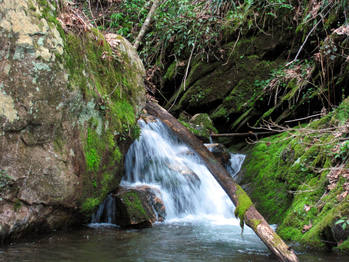
The next stretch of the tour is the most difficult of the whole journey as the old trail we had through here from 20+ years ago has long since gone. Even back then when we kept it clear, it was still not easy, as it is rugged terrain, only we were much younger then and it seemed much easier as we used to almost run through here ! Despite its roughness, there is much beauty to be found buried below the rocks, laurels, and steep ravines in the form of many small waterfalls and cascades.

purple flowers
Making our way carefully down the steep left side of the creek, it narrows down to where there are multiple small falls and cascades and then yet another small cliff you must manage your way down and around the right side of which takes you down to where another creek comes in from the ‘unknown hollow‘ (that is yet to be fully explored) on the left. This is a unique and awesome place in itself where it comes to a ‘point‘ and the two creeks converge, and you must carefully make your way down the cliff and around the face of it to cross the creek that comes in on the left side (view looking back) so you can climb the steep knob ahead to get around to the top of the next set of falls (Josiah) that you can actually see from there. You can go down the creek instead to reach the top of the falls as it is a really cool place to hang out, but you can not get down from there. A beautiful set of falls and cascades is found right there on that creek to the left. I can’t wait to one day explore that hidden valley as that is about the only region that remains un-chartered by us in the entire Clarks Creek area. I took a few moments here to take some pics of these falls while the others made their way around the cliff and across the creek and began the climb up and over the knob where the hardest of descents down the next falls (Josiah) was yet to come.

Small falls above Josiah Falls

Falls and cascades above Josiah Falls
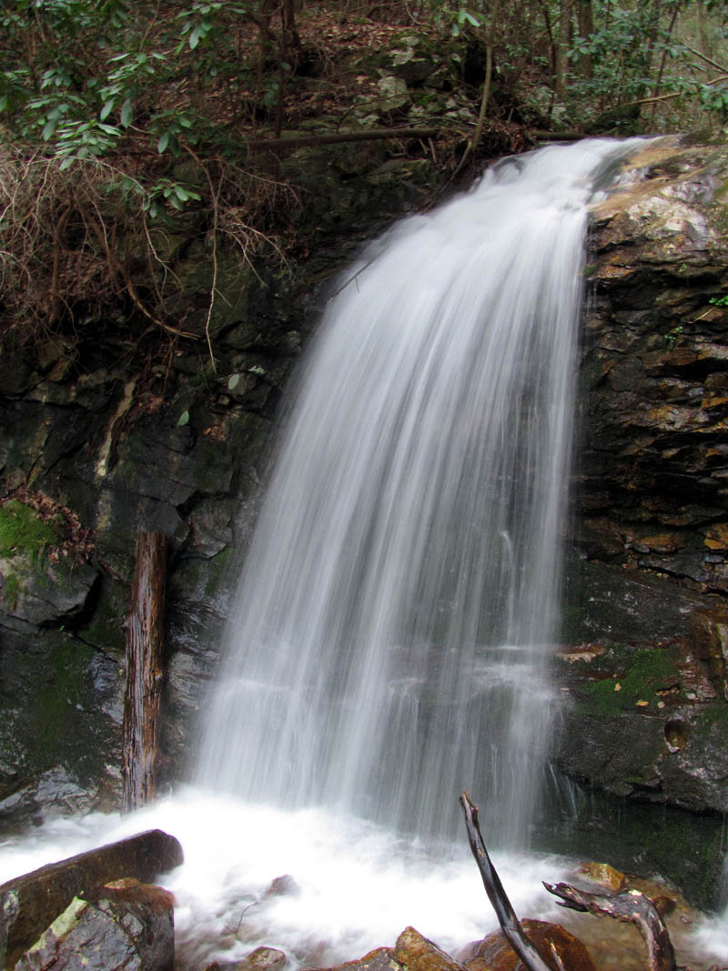
It is a short climb up from the creek crossing to the top of the knob where you can then see the next set of falls (Josiah). You find yourself looking right down on the top of the falls and can see the waterfalls above that stair step down just before it shoots off the top and falls down the vertical part of the falls. You are unable to see these from the bottom (as is the case with many waterfalls). There was a lot of water flowing today which made this entire trip very visually appealing. From the top of the knob, you must carefully make your way out to the left as far as you can before you can do another ‘slide for life‘ down the hill to the creek at the bottom of the falls. There is now a really large tree down there that blocks the way so you have to go down a steeper part, so descending these falls is harder than it used to be but, still doable as long as you take your time and carefully choose each step as you negotiate around this formidable obstacle. Once you get down below the tree you can slide the rest of the way to the creek at the bottom. Then you get the awesome view of these gorgeous falls. You can also see some impressive rock cliffs that reside much higher on the knob that I want to explore one day.

Josiah Falls

Josiah Falls
We were making good time at this point with still plenty enough daylight to get out easily before dark so we spent some time here to take in all this vast beauty as these are some very nice waterfalls. I took as many photos as I possibly could from every available angle and then after a long break we reluctantly continued out the Devil Fork Valley.

Josiah Falls

Josiah Falls

Josiah Falls

Josiah Falls
After Josiah Falls you have to pass through some large rocks and boulders keeping to the right side of the creek, passing by a few very nice cascades, a swimming hole or two, a ‘sex rock‘ (don’t ask) and then eventually you have to cross the creek and climb up the steep bank on the other side to reach the start (or end) of an old road above. We found a dog tracking collar laying on a rock at the bottom there before we climbed up to the old road. There is an old tree with many initials and things carved on it not far from there. After taking one last look back at Josiah Falls and the cascades below them, we headed on down the old road.
Cascades below Josiah Falls

Cascades below Josiah Falls
After getting on the road it is more or less a cakewalk the rest of the way out as it is an actual trail, only slightly overgrown, although you do have to know where to get off the road and go over to a lower trail off to the right before another creek crossing or you`ll end up going up the hill to the left into another draw which is not the way to go. Eventually, you end up on a faint trail that goes through some dense pines to another creek crossing and it then becomes more defined as it follows the left side of the creek until it reaches the big curve to the left where another small creek comes in from the right just as you reach what we call the ‘Volcano’. Following the main creek around the left curve you pass by some more cascades and then reach the top of Pine Ridge Falls.

Cascades above Pine Ridge Falls

Cascades above Pine Ridge Falls

Cascades found at top of Pine Ridge Falls
Pine Ridge Falls are always nice. Crossing over them to get to the other side in order to continue on the trail to where it comes out on Longarm Branch Trail can be quite challenging, at least for some people. ‘Fireball’ made it well known that she did not like crossing these and would most likely never do it again but, she did really well.

Pine Ridge Falls

Pine Ridge Falls
Pine Ridge Falls (left side)

Pine Ridge Falls (right side)
We took another break there to let the adrenaline levels calm down some before continuing on to the Longarm Branch Trail where we went right and followed it back to where it starts on Clarks Creek Road where we had left our vehicle that morning. I was pleased that there was still daylight left and I marveled at the sight of Longarm Ridge as we made our way out to where the Lower Longarm Branch Falls are, which made a fine ending to a perfect waterfall tour day.

Lower Longarm Branch Falls

Lower Longarm Branch Falls
Please visit our Photo Gallery for more waterfall and mountain pics.

 My name is 'RAT' and I love the mountains and waterfalls of the East TN. area where I live and I hope you enjoy this blog about my outdoor adventures.


One Comment to “Devil Fork Falls aka The Waterfall Tour – 4-3-2011”