


Horse Creek – 12-3-2011
It has been many years since I did any hiking in the Horse Creek area and even longer since I have visited the falls on Pete`s Branch so, my friend Bol’Dar and I decided we would take advantage of the recent rains and get some decent pics of the falls. This seemed to be a good plan as the weather was fair for an early December day and the water levels had risen due to some recent rainfall in the days prior, however, this turned out to be not such a good idea. It seems we had not given any thought to it being the peak of bear hunting season and we found ourselves in the middle of at least a dozen trucks and even more hunters with their guns and hunting dogs all trying to kill a bear. As we walked up the rough forest road, we were passed by a few trucks in a hurry to get somewhere and we were told that it might not be a good idea for us to be walking there as they informed us there was a bear being chased in our direction which includes lots of hunters with guns. We were also reminded that we were not wearing orange as is required by law during this time of year and that my black pack would resemble a bear from a distance ! Of course this did not scare nor hinder us and we continued our trek towards the falls, stopping to check out the many cascades found along the way.
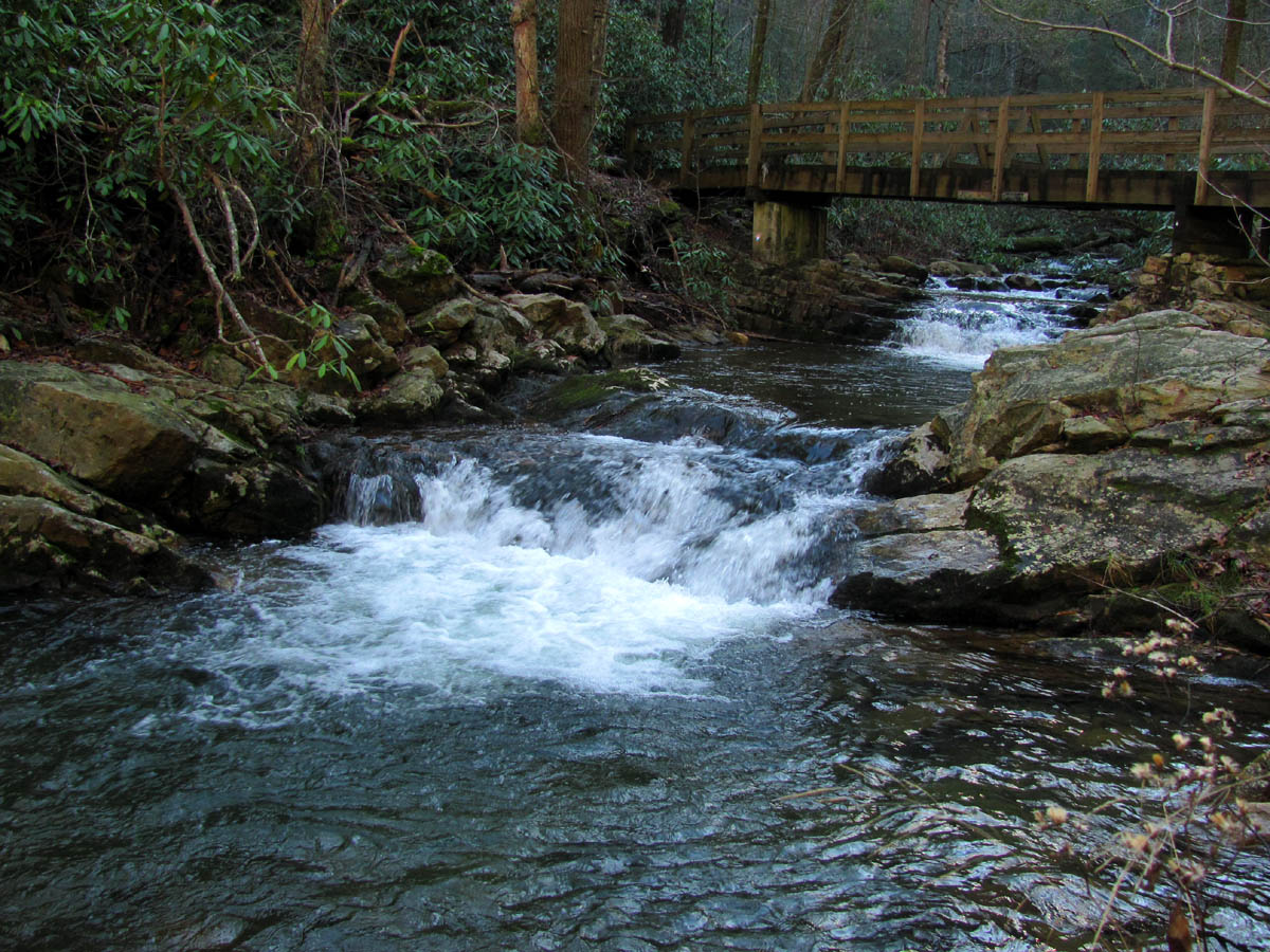
Horse Creek flowing under the Squibb Creek Trail Bridge
There are several creek crossings that one must perambulate in order to reach our destination but we did not have any difficulty in doing this without getting wet. It did not take long to reach the first turn off to the Sarvis Cove Trail but when we reached this point we could hear a multitude of dogs barking that was coming from that direction. It was fairly obvious that this was the ‘hot spot’ where the bear party was being held so we got off the road and hid out by the creek for a snack break hoping they would get their bear and move along. After the break we went back to the road and all was quiet so we proceeded in that direction only to find all the trucks and hunters, their dogs, kids, etc all sitting there where the road dead ends and turns to trail, all listening to their 2 way radios. I spoke with one of them who told me that the other hunters and dogs were actually up in Pete`s Branch right at the falls where the bear was. It was becoming apparent that we would not be able to get to the falls on this day. This was disappointing but determined not to let it ruin our day, we retreated back the way we came and started over deciding we would wander up the Squibb Creek Trail instead knowing there would not be any hunters in the Sampson Mountain Wilderness area.

Cascades along Horse Creek

Cascades along Horse Creek

Reflections on Horse Creek

Water flowing over a log in Squibb Creek
I had not been to Squibb Creek since February 19, 2010 when my son Tyler and I waded through deep snow all the way to Squibb Creek Falls. We did not think we had enough time before dark to make it to the falls and back but hindsight now reveals that actually we would have. After crossing the bridges, we stopped for a few minutes to check out the cool A-Frame style house that is privately owned and located right on the Squibb Creek Trail. There is a small waterfall just behind it and they even have a cool rock shaped like the state of Tennessee! We crossed the creek there and made our way past an old homestead area at the entrance to Turkeypen Cove to where the Middle Spring Ridge Trail begins on the left. We made the choice to take that route to gain some elevation and get some visuals from ‘the balcony’. I had been wanting to hike this trail to see what kind of shape it was in as I had not been there in a long time. It seems the last time I was up that way was on a hike with Bol’Dar and an acquaintance of ours, Joe Parrot, whom we have not seen now for close to 15 years. We thought of him as we started the grueling climb and wondered what ever happened to him. I knew we did not have time to reach the crown jewel, the ‘Buzzards Roost’ a rocky overlook that sits at the top near the ‘Ball Ground’ on Coldspring Mountain that looks out over the Rocky Fork Valley. I had forgotten just how steep the trail really was but was soon reminded as we gained elevation very quickly. We were both surprised just how good of shape the trail was in. It seems that some trail work had actually been done in recent years. It took awhile to get near the gap at the top and we worried that we would run out of time and have to turn around to avoid coming back in the dark but, I was hoping that we could at least make it to the gap and take the Turkeypen Cove Loop Trail back to Squibb Creek to avoid any backtracking. I had always wanted to hike that trail and it was a gamble not knowing if it was still there or even if it was passable. In recent years so many trails have been devastated by the Pine Bark Beetle damage that you can easily find yourself in a ‘meat-grinder‘ hell and we definitely did not want to deal with that!

Private Chalet along the Squibb Creek Trail

Small falls directly behind the private chalet

Going up the steep Middle Spring Ridge Trail
The trail meanders a considerable distance off to the right, paralleling high above the Squibb Creek Valley, crossing over many ridge ‘fingers’ as it leisurely makes it way towards the gap. It did not take long to gain some serious elevation and the views were very nice. We had to take several breaks due to the steepness which delayed our progress even more. We finally reached the last and main ridge ‘finger’ and switchback that I recognized as the one I went down one time when I was trying to come out at the Squibb Creek Falls but recall falling short as the falls are still farther up the valley below. From there I could see the main ridge above us which gave me an idea of how much farther the gap would be. It was still a ways off but this ridge line would now take us straight up to it and I was determined to make it to that point even if it meant walking some in the dark.

Looking over one of the 'ridge fingers' and the Squibb Cr. Valley to Coldspring Mtn. in the distance

View of the valley in Greene County (looking North)
We started seeing some snow beside us at this time and off in the distance we could see the high part of the mountain where the Appalachian Trail goes across Coldspring Mountain and above the head of the Squibb Creek Valley. It was white up there. After a short rest and snack break we resumed our climb and before long the narrow ridge became less steep and opened up as we approached the gap. I was happy to be in the gap knowing that there would be no more climbing on this day but at the same time feeling disappointed that we did not have time to continue up to the ‘Buzzards Roost’ and I was still disturbed that we were unable to go to Pete`s Branch Falls. There was more snow in the gap and we checked out the Turkeypen Cove Loop Trail which did seem to still be there and looked like it had actually been traveled some in recent years so feeling adventurous we chose to take that direction for our return trip. We did get some good visuals of the backside of Sampson Mountain over the three forks of Cassi Creek.

Coming in to the gap

View of the "Ball Ground' up top where the Middle Spring Ridge Trail comes out on Coldspring Mountain

View over three forks of Cassi to Painter Cr and beyond with Embreeville Mountain in the far distance

View over Cassi into the Sampson Mountain Wilderness. Can see Pinnacle Mtn. in the far distance
This turned out to be a good decision as the trail was there and turns out it had some very recent trail work done to it as we did see some fairly fresh grading. The trail wasted no time in becoming an extremely steep descent dropping off the edge of the world there, down the connecting ridge from the Middle Spring Ridge which is on one side of the Turkeypen Cove over to the unnamed ridge that is on the other side of the Turkeypen Cove. The trail doesn’t go all the way to the other side but, only about halfway where it then veers left and switchbacks steeply down into the left side (the way we were facing) of the cove.

Standing on the edge of the ridge just before the steep descent into Turkeypen Cove (you can see the opposite ridge of the cove in the background)

Sitting on a rocky outcrop looking out over the Cassi Valley towards Sampson Mtn.

Sun setting over Middle Spring Ridge and the surrounding mountains of the Horse Creek area

View from ridge over the Middle Spring Ridge towards Horse Creek and Green Ridge

Our last view of the valley before descending off the ridge into the lower part of Turkeypen Cove

Sunset from the Turkeypen Ridge
The sun was starting to set over the distant mountains by this time but I was glad we came this way. The trail only gets better as it meets the upper valley floor and it does have switchbacks until it reaches a small water source that feeds into the cove. The trail is very scenic for the rest of the way as it connects over to the main center of the small valley where it then follows that the rest of the way out to Squibb Creek back to where we started. It did not take very long to follow this direct route off the mountain and we ended up making it back to the car just before dark. The sun was almost gone and the sky cast a pink eerie glow over everything. The moon was already up just before we reached the car. Despite not being able to make it to Pete`s Branch Falls due to the bear hunters, it was still a nice hike and as always was a great day to be in the woods.

Small waterfall on Squibb Creek behind the A-Frame house that I took on our way out

 My name is 'RAT' and I love the mountains and waterfalls of the East TN. area where I live and I hope you enjoy this blog about my outdoor adventures.


One Comment to “Horse Creek – 12-3-2011”