


South Harper Creek Falls – 6-26-2012
On Tuesday, June 26, 2012, I went with my waterfall crazy friend Dave and our friend Lou to find the South Harper Creek Falls in North Carolina. [Note: There is NOT really a South Harper Creek ! These falls are actually on Harper Creek but they are named South Harper Creek Falls to avoid confusing them with Harper Creek Falls (which are downstream below them ; I am unsure why they are not called Upper and Lower) and the North Harper Creek Falls]. Leaving Hairnt-Quarters around 9 am, we found the trail head for Trail # 260 where it begins/ends on USFR # 58 by 10:30 am. It was a sunny day and the laurels were still in full bloom as we made our way down the very nice orange blazed trail. I noticed they put the blazes on the inside of the trees so one blaze has to do for both directions instead of painting them on the outside of the tree with one for each way. The trail is in great shape and was level for the most part. It wasn’t long before we reached a slight turning point in the trail where there is a large farm located on private property on the forest service boundary line, where the trail veers to the left to go around the edge of it. After this the trail soon turns back to the right and goes down a short hill where it reaches a trail intersection and Harper Creek. Going to the left will continue on Trail # 260 and take you to the top of the falls but going to the right will lead you quickly to the creek where you must cross to get over to another trail intersection. We thought this was where the MST (Mountains To Sea Trail) was but we later found out that it no longer goes this way. We would check out that area and the cascades found there later on our way out since we would be coming back this way.

South Harper Creek Falls
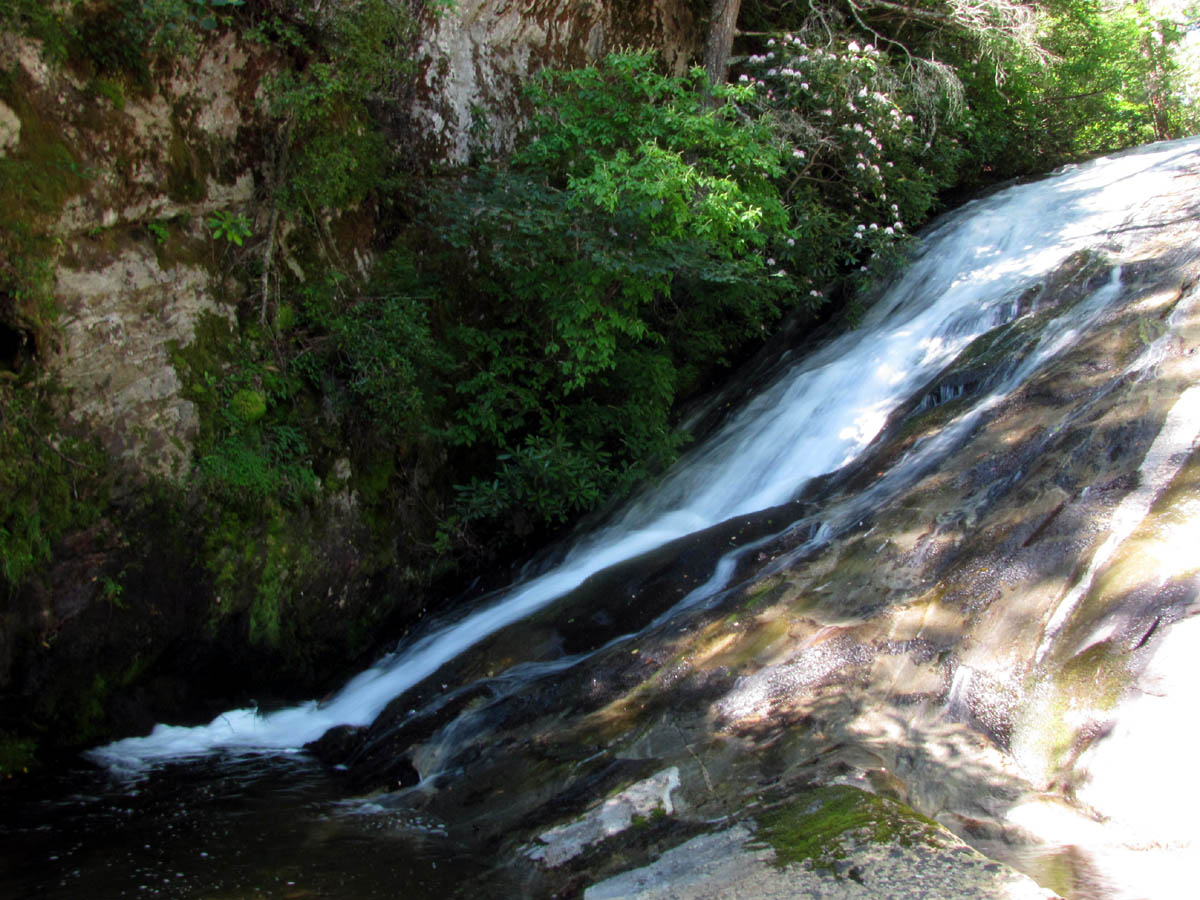
We continued to the left where the trail meets the top of the falls just before it goes further left and down a fairly steep hill which is the way to the bottom of the falls. We found the short side trail over to the top of the falls where we walked out onto the large area of bare rock there and dropped our packs as well as our jaws when we got our first view of this amazing waterfalls. These falls are very unique and much different than any I have ever seen. They are actually of the cascading type but in a major way as the first drop of about 20+ feet with a nice cascading waterfall as the water all then goes narrowly to the opposite side before dropping down the main upper part of the falls. It then levels out for a short ways before it drops over the wider and MUCH steeper edge of the main and lower half of the falls. The view from there is incredible as you look off of a drop of over 100 feet into an impressive gorge carved out of rock that is all around you and extending way higher than words or pictures can describe.

First view from the top of the South Harper Creek Falls (Photo by Dave Aldridge)

View from the top of South Harper Creek Falls

View from the top of South Harper Creek Falls

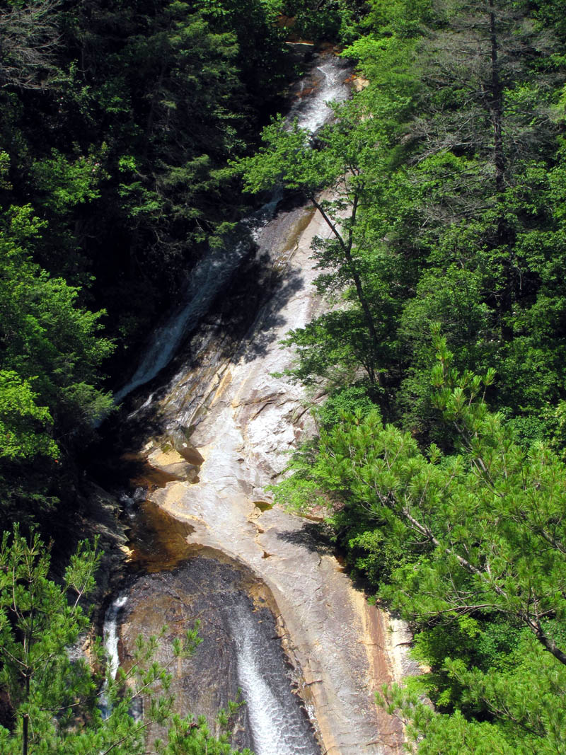
View off top half of South Harper Creek Falls

Uppermost part of the South Harper Creek Falls
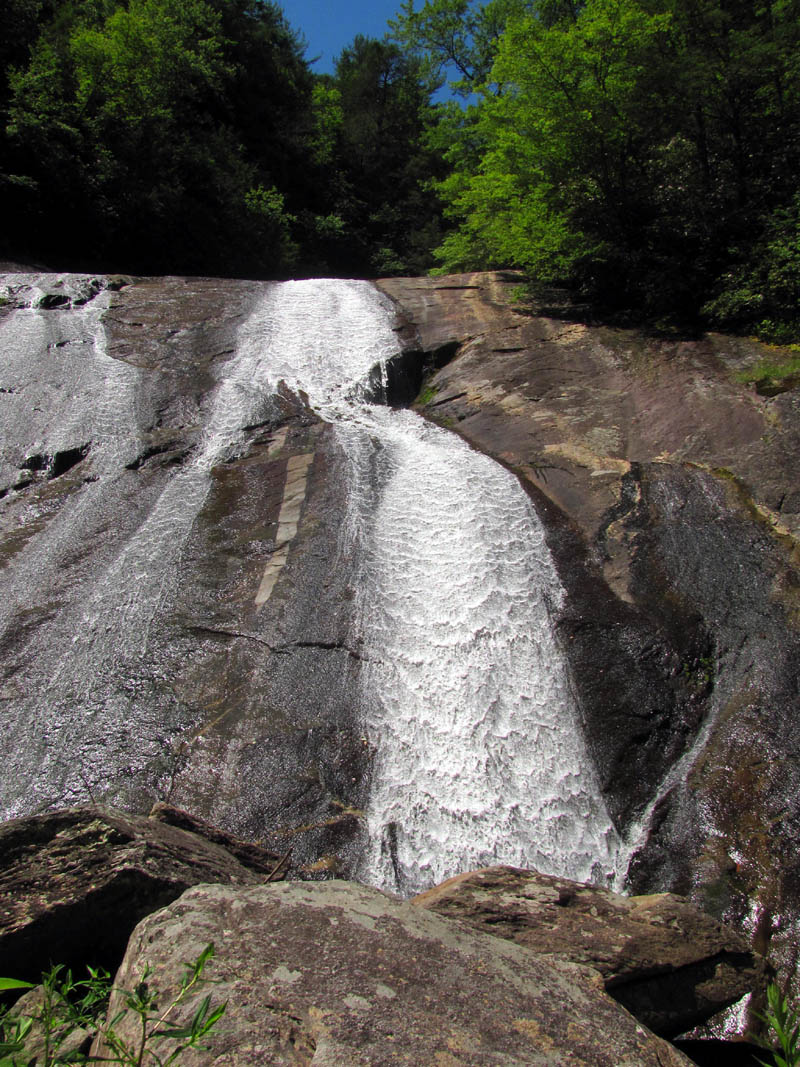
I must put a warning here because this can be a VERY DANGEROUS place !!! You can go down the left side of these falls for quite a ways (if you dare !) as they make their way over the edge IF the rock is DRY !!! And even then, you must be extremely careful as one stumble or trip could mean certain death as you most likely would not survive a plunge over these falls. This is definitely not a place for any young children unless you keep a hold to them the entire time. If it was slightly wet with even the morning dew I would advise staying off the rock. Luckily it was very hot and dry when we were there so I was able to go down quite a ways to get some pics of the surrounding cliffs, the gorge, and the bottom of the falls but I can assure you that even the most daring of people will get a feeling of vertigo when standing anywhere in that zone. I could see the tops of the lofty cliffs that loom high above the other side of the falls and I knew that one would have to be up there in order to see all of these falls at one time,,,hmmmm,,,,
Top half of the South Harper Creek Falls

View from the top of the lower half of the South Harper Creek Falls

Looking at the upper half of the South Harper Creek Falls as it makes its way towards the lower half

Following the creek as it and I make our way down towards the top of the lower half of the South Harper Creek Falls

Moving even further down towards the top of the lower half of the South Harper Creek Falls (this can only be done when the rock is dry and I DO NOT recommend it)

Looking off the top of the lower half of the South Harper Creek Falls

Looking down from the top of the lower half of the South Harper Creek Falls (this is as far as you can go on a dry day without falling and this is VERY DANGEROUS !)

Standing on the super steep slope at the top of the lower half of the South Harper Creek Falls (Photo by Dave Aldridge) (One slip here is certain death so if you must please do at your own risk, I do NOT recommend this)

View from the top of the lower half of the South Harper Creek Falls
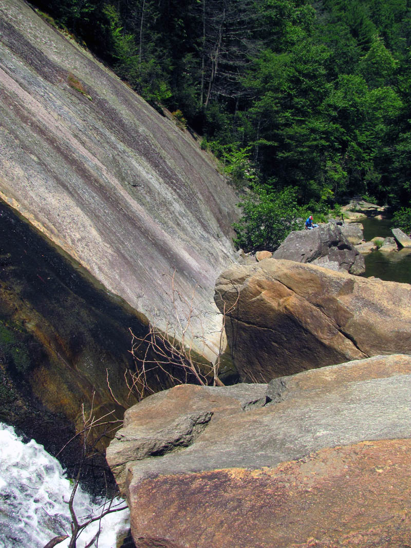
We hung out at the top of the falls for quite awhile before getting back on the trail to find our way down to the bottom as it seems the creek is in the shape of an ‘ L ‘ so as soon as the falls make it to the bottom, the creek makes a hard turn to the left and continues out the very rocky gorge to continue on its way. After following the trail for a very short ways it becomes obvious that you have to find your way off trail down one of the many routes that have been made to reach the bottom. This is very steep and also a bit rugged but we had no trouble and were soon standing at creek level looking over the boulders at the falls that were now a short distance away from us. Although they were close, getting over to them was not going to be easy as the boulders there that one would have to climb over are very large and spaced out just enough to where one could not just jump from one to the other and of course having water between them would mean getting wet if one was to slip or fall. Of course this did not stop me so I made my way over the first few of the car sized rock formations as I surveyed the best route to reach the place I wanted to go to.

Lower part of the South Harper Creek Falls

The canyon-like gorge below the lower half of the South Harper Creek Falls

Looking back at Dave and Lou after I had gone a very short ways over the first of the large obstacles (the rocks are farther apart than they appear)

Looking into the rocky gorge at more large rocks I would have to negotiate

Getting closer to the butt end of the canyon
You can see the butt end of the gorge where the water has carved out this amazing place and it looked dark and cave-like. (See if you can find ME in this picture Dave took !! ) I knew I had to see that up close and personal but it was not going to be easy. As I continued negotiating the oddly sized and unevenly spaced rocks, having to contort my body and cling by my fingertips and toes and belly crawl in places to get over the gaps and spaces between them, I made my way closer and closer to the bottom of the falls and this dark, cavernous chasm. It took awhile but I eventually made it parallel with the falls where I could take some pics from that angle. The sun was intensely bright which ruined any hopes of getting any good shots so I will be coming back here for sure. Besides, my friend Bol’Dar is gonna love this place so we definitely will be back.

A view of the falls from about halfway into the canyon
View of the falls from about halfway into the canyon

View of the destination as I get closer to it

Almost to the end !
Looking back at Dave from almost the end of the canyon
There were even more obstacles that you can not see from where I started, consisting of more huge boulders and gaps between them that became harder and harder to cross but my persistence finally paid off when I made it as far as you can go to the very end of this vertically sided crevasse. Looking back I felt as if I was in a large crevasse only without the ice. Looking into the armpit of this thing, I could then see that it was not a cave (not that I thought it would be one) but rather a water carved cavity which formed a sort of cleavage between the two vertical sides. It was a really nice spot with a secluded pool of water with assorted grasses and weeds growing there plus it has a miniature cascade that trickles in from the same side as the waterfalls which make it a rather picturesque setting. I was glad I had made the extra effort to get there although I doubt I would do it again. I did stay there for a bit to enjoy it since after all it had taken a lot of effort to get there and would take an equal amount of effort to get back out. Looking back at Dave and Lou it seemed a really long way to return !

Still trying to get to the back of the canyon

Colorful rocks found at the end of the canyon

Pool of water found at the back of the canyon. (there were fish in it)

Water flowing into the pool at the back end of the canyon from the falls

Looking up at the left side of the falls from the butt end of the canyon

View of the right side of the falls from the butt end of the canyon

Looking back at the way I would have to take to get back to Dave who was now a little ways into the canyon
The sides here are near vertical and was like standing in a skyscraper sized V. As I made the laborious journey back over all the Herculean sized rocks I could not stop thinking about the top of the rock cliffs that are on the opposite side of the falls and after having seen a photo taken from there of the entire falls, and knowing that would be the only place to document such a shot, I knew that I would be finding a way to get there. What I did not know was there was a much easier way than the one I would choose. As I finally made it almost back to Dave and Lou, I stopped to check out the largest pool found at the bottom of the falls which is actually along the base of the cliff on the opposite side of the falls and starts off shallow but then there is a deep abyss that I could see no bottom for. Being surrounded by solid rock all around, this would be a good place to swim as long as you are not afraid of fish as I could see schools of what looked like baby rainbow trout swimming everywhere there.

View of the canyon as seen on my way back from the far end of it

Near vertical sides of the canyon

Near vertical side continuing way up above me !
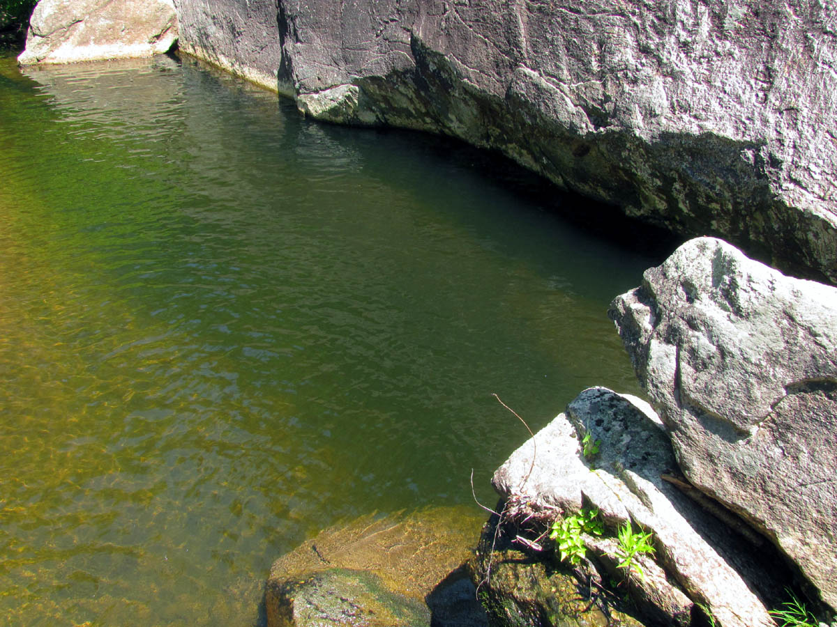
Bottomless water hole

Baby rainbow trout
I was now close enough to Dave to communicate as he climbed over a couple of the large rocks to get a little view of what I had just gotten a whole lot of. I was ready to be out of the hot sun so I passed him on his way in while I made my way to some shade where Lou was. I could see Dave riding one of the rocks like a cowboy breaking a wild stallion.

Dave riding one of the huge rocks !
After he rejoined us we crossed the creek to check out a trail I seen on the other side as I was interested to see if I could find a way up that ridge to get to the top of the cliffs and also to check if there were any other falls or cascades below us. The trail did continue down the gorge beside the creek but I did not see any more falls however, I did find an interesting pile of bones that I must assume was a small deer. Dave and Lou opted to go back across the creek and eat their lunches while I decided to make the climb up the steep ridge to the top of the cliffs. It would not be far just incredibly steep. I dropped my pack to make it an easier climb but I would later wish I had taken it along as I would be very thirsty once I got there.

Bones found along the creek

Bones found along the creek

jaw bone and teeth
I found a place to access the ridge, actually right near the bones where I started climbing and looking for the path of least resistance, making my way around the obstructions I found there. All in all it was really not that bad and it did not take but a few minutes and a couple short rest breaks to reach the first of the rocks that are perched on the edge of the cliff. It was apparent that anywhere to my right was a drop off of what was quickly becoming hundreds of feet. I came to one large area of rock that I could not climb so I had to make my way around the outside edge on the right side using my fingertips to hold on to tiny little holes in the rock. This was a bit risky and is also where I got my first view of the South Harper Creek Falls. I could see the upper half from there.

Climbing the steep cliff ridge to get a view of the South Harper Creek Falls

My first view of the falls. (notice the little holes in the rock I had to use as finger holes to climb higher up the steep rock cliff)

Better view of the falls as I continue to climb this nearly vertical rock

Still more to climb and believe it or not, that is still not the highest point !

The top (highest point) where the best view would be, is above this rock. I decided to stop here and not risk climbing it alone.

My view of the South Harper Creek Falls
Of course my goal was to see the falls in their entirety so I continued around this hindrance and once I got to the top of that dinosaur egg I could then see the lower part of the falls. There was a narrow ledge there that continued below an even larger part of the cliffs forming a vertical wall behind me but luckily there were some pine trees growing on it that I could use to hold on to and give me at least some sense of security as I made my way higher to get an unobstructed view of the 200 ft tall falls that were now so far away and below me that they looked tiny. At this point I was very hot and thirsty so I was wishing I had brought my pack along. To make matters worse I suddenly needed to use the bathroom and of course the TP was in my pack !

Looking up from my vantage point at the highest point of the ridge above me
Zoomed view of the upper part of the South Harper Creek Falls

South Harper Creek Falls
I could tell from that point that the best view would be from the enormous rocks above me but I was not willing to risk the climb that would be required from where I was, at least not by myself so, I settled for the shots I could get and then made my way back down the way I had came. Some of this would be harder than it was when I came up but I was soon off the rocks and back on the narrow and really steep ridge line. I continued downwards and somehow found myself on a slightly different route than I had taken going up ending up a little too close to the edge so I had to climb back up some to get back on the center part of the ridge. After that I kept making my way further down and down and after awhile it seemed like I would never get back to where I started as I knew it was not really that far and should have been even faster going back. I was hot, thirsty, and very tired at this point so I just kept going down until eventually I knew I did not recognize anything from before. This instantly gives you that bad feeling but I knew that all I had to do was get down to the creek where that other trail was so I found a place and just bushwhacked my way over and down to it where indeed I did find the trail. I was glad to be off the ridge and back to the creek. It had been awhile since I heard Dave whistle at me so I started hollering at them but got no reply. I knew they would not leave without me so I thought that was very strange. Oh well, I kept following the trail back up the creek looking for the bones and the place where we had crossed but everything I was seeing was totally new to me. After hiking up the creek for a good ten minutes and still no sign of anything familiar and no sounds from Dave, I knew I had gone way too far down that ridge and had passed the place where I started on it. Another 5 minutes or so of hiking up the creek and finally I came to the bones and could then make contact with Dave and Lou.

View looking back at the way I had to return from the point where I stopped climbing

One last view (zoomed) of the upper half of the South Harper Creek Falls
I was feeling very tired, nearly exhausted at this point and needed to find a place to use the bathroom, and I also had not yet eaten anything so Dave and Lou began the arduous ascent back up to the Trail # 260 while I took care of business. The first thing was the bathroom break, after that I felt much better but had just pulled a tick off me which is never a good sign. I would end up finding two more, one of which would get his head in me by the time I got home. After I ate my lunch and drank some water I was finally rested up enough to begin my climb back to the trail and then on to the top of the falls.

Back to the top of the falls

View from the top of the falls
I soon caught up with Dave and Lou at the trail intersection where Dave and I decided we would take the trail to the left and cross the creek there to get a view of the nice cascades found there. Although this does lead to the private property (the farm we seen on the way in) I am sure it is ok to at least go far enough to view the falls I would just not go beyond that and actually trespass on their property as it does have signs saying not to. Lou opted to stay on the other trail and rest while he waited on us. Upon crossing the creek we could see not only the cascades but also another trail that led to the left which looked to me to be going level right out to the top of the cliffs where I had just climbed up to the hard way. I would later learn that indeed this trail does go there and it is a much easier and more efficient way to do so. It seems that trail goes over to the other ridge there where it actually meets up with the MST Trail (that has gone around the farm on the backside over a big hill) where there is a short side trail that leads right to the top of the cliffs. I will definitely be going that way on my next trip here !

Cascades located just above the top of the South Harper Creek Falls

Cascades located just above the top of the South Harper Creek Falls
We went up the creek towards the private property to get some closer pics of the cascades and came across a unique thing laying on the edge of the water that was also attached to a tree by a steel cable to keep it from being washed away during high water. It seemed to be some sort of old mill wheel of sorts that would have been used way back in the day to use water power to turn wide belts to do various milling operations. This was very interesting to see.

Old milling equipment laying in the creek

Old milling equipment found in the creek
After checking out that area we knew it was time to get back so we went back down the creek to cross it and find Lou. Dave whistled loudly and we heard a voice say “You looking for me?” which sounded like Lou to which we answered back but never heard another sound. We proceeded to cross the creek and make our way the very short distance to Trail # 260 and there was no Lou. We whistled and hollered but got no response. We knew he was just there (or so we thought) and knew also that he would be taking his time up the climb there so we took off up the hill but once we reached the top there was still no Lou and despite many calls we got no answer. This was very weird. We knew he could not have gotten that far ahead of us that quick so Dave opted to go back down and look for him. I was too tired after the climb up to the cliffs so I waited while he went down and back. Still no Lou. We had no choice but to head back out and after walking for about 15 minutes we finally found Lou who was then on his way back since we had not made it to where he was yet. It seems that was not him we heard while down at the creek and apparently he had hollered and told us he was going to start back but we did not hear him. After fussing at him for leaving without getting an acknowledgement from us we were just really glad to have found him and we then all walked the mile or so back to the vehicle. It had been another most awesome day in the woods to the best falls to date and I can not wait to come back here on a more cloudy day and to show my friend Bol’Dar. Until next time, have fun and be safe hiking.
To see these pics and many more of these magnificent falls, please visit our Photo Gallery HERE.

 My name is 'RAT' and I love the mountains and waterfalls of the East TN. area where I live and I hope you enjoy this blog about my outdoor adventures.


One Comment to “South Harper Creek Falls – 6-26-2012”