After our last trip to Bard Falls in the Harper Creek area a week ago, we completed seeing all the waterfalls that area had to offer so this week we found ourselves at the Upper Creek Falls. These falls are also located in North Carolina and not far from the Harper Creek Valley on state highway 181 that runs between the Pineola and Linville Falls area and Morganton. Arriving at the trail head around our usual time of 10:30am, my friend Dave, who had already been here before, educated me on the layout of the trails while I took some photographs of the Beacon Heights Tower. Here is a zoomed pic so you can see it better. (It seems like you can see that structure from anywhere around here). There are two trails to choose from here, the Upper Falls trail and the Lower Falls trail which when combined allows for a very nice loop hike. Since we were planning on exploring the creek above the upper falls to possibly discover some more falls or cascades, we chose to go on the upper falls trail and if time and weather allowed, to come back on the lower falls trail.
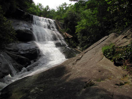
Upper Creek Falls
(more…)
Posted on 7 September '12 by RAT, under RATtreks. No Comments.
After going to Harper Falls last week, my friend Dave and I only had one more falls to see to complete all of those within the Harper Creek Valley and that was Bard Falls. This was finalized on Aug. 1, 2012. Starting at the trail head located on FR #464 where the Mountains To See Trail joins the road from Harper Creek (signage displays ‘N. Harper Shortcut’ #266 A but some maps will show this as #440) we went downhill on the MTS/ 266A Trail for about one mile to reach the Valley floor below. This was a red blazed trail along with the white circle blazes of the MTS Trail. The first thing we encountered before even out of sight of the vehicle was a yellow jacket nest in the ground that had been dug out by a bear or raccoon. It was still active so we wasted no time there. This is a very well maintained trail, gradual in its descent, passing by a few water sources as it makes its way down to the Harper Creek. Just before reaching the bottom there was some really nice ferns growing that were a pleasure to hike through. The trail leads down to Trail #266 which is the main trail beside Harper Creek. Taking a left there we followed that trail downstream towards the falls. This will be a blue-blazed trail with white dots. One of the blue-blazes we found on the return trip was very different !
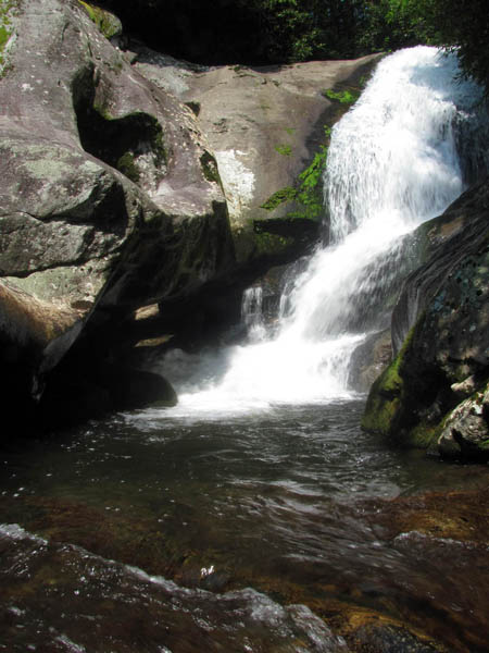
Bard Falls
(more…)
Posted on 29 August '12 by RAT, under RATtreks. 2 Comments.
After taking a break from the Harper Creek Valley for the past two weeks, which we spent hiking in the Little Lost Cove Creek (falls) and Big Lost Cove Cliffs area instead, we planned a trip to Bard and Harper Falls on July 24, 2012. The original plan was to take two vehicles and leave one at the bottom in the Wilson Creek area and then take the other back to the top and walk downhill one way to see both falls, however, that plan did not come to fruition. Instead, we decided to just take one car and go to Harper Falls from the bottom and return back the same way. It is only 1.5 miles or so to the falls so this was easily doable and would allow for plenty of time to enjoy the falls and get out before the afternoon thunderstorms that our meteorologist Rob Williams predicted to arrive to the area around 2pm. Leaving Hairnt Quarters around the usual time of 8:30 am it took longer than the usual hour and a half to get there since we took a different and more scenic route to get to the Wilson Creek area. Instead of going to FR # 464, we chose to go up the Blue Ridge Parkway instead and take a gravel forest road that I think is # 1514 that eventually end up in Wilson Creek at the Edgemont community where the road becomes SR # 90. That is of course the same road and same place where FR # 464 comes out. From there we had to continue to Mortimer where we turned right on SR # 1328 for about a mile or so to the trail head where there is parking located on the right for trail # 260 which leads into the Harper Creek Valley.
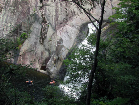
Upper part of Harper Falls as seen through the trees from the trail above
(more…)
Posted on 17 August '12 by RAT, under RATtreks. 2 Comments.
Ever since our trip to the Little Lost Cove Cliffs on 6-13-2012, I have been wanting to see the Big Lost Cove Cliffs. This is because as awesome as the little ones are the big ones must be much better right ? On 7-16-2012 I would get my answer. My friend Dave and I arrived at the trail head at our usual time of 10:30am after the hour and half drive over the mountain to North Carolina. It was a partly sunny and hot day with chances of thunderstorms so it was looking like we would have some clouds that would help make the pictures turn out better although we did not want to get caught in any storms while out on the exposed rocks.

Dave on the Big Lost Cove Cliffs
(more…)
Posted on 8 August '12 by RAT, under RATtreks. 4 Comments.
Once again we found ourselves back in the Harper Creek area of North Carolina except this time we decided to go on the other side and venture down the Little Lost Cove Creek where there are two really nice falls. From reading information I found available about these falls I was expecting it to be a harder hike and nowhere near as nice a falls as they actually were. I found this trip to be easier than described and the falls to be much bigger and more awesome than anticipated. We arrived at the trail head around our usual time of 10:30 am which is located off FR 464 in between the two trail heads for the Lost Cove Cliffs which are on the other side of the road. You will turn off onto FR 464A and follow it down into the Lost Cove Creek hollow where you will cross a shallow creek and then the road ends in a circular parking area where you will park and see the trail leading down to your left on an old road bed over some dirt humps designed to keep vehicles out. It is not too far down this very nice trail to where you will find a noticeable trail leading steeply down to the right. There is a small log laying perpendicular across this trail there. This is a decent trail but it is STEEP !! It goes down and down past this big tree with a HUGE growth on it, until you come to the upper falls. You will have no trouble hearing or seeing them from this trail so you wont miss them. You will have to go down another steep side trail to get down to the falls. The main part of these falls is about 40+ feet in height but like many other falls there is more to them above which can not be seen all at one time so they are actually overall about twice that height.

Upper Little Lost Cove Creek Falls

Lower Little Lost Cove Creek Falls (Photo By Dave Aldridge)
(more…)
Posted on 31 July '12 by RAT, under RATtreks. 3 Comments.
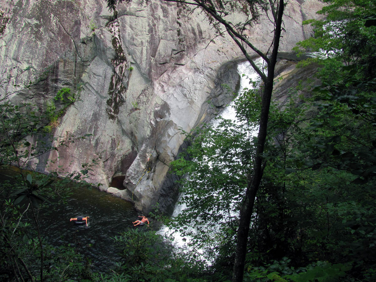
On Tuesday, June 26, 2012, I went with my waterfall crazy friend Dave and our friend Lou to find the South Harper Creek Falls in North Carolina. [Note: There is NOT really a South Harper Creek ! These falls are actually on Harper Creek but they are named South Harper Creek Falls to avoid confusing them with Harper Creek Falls (which are downstream below them ; I am unsure why they are not called Upper and Lower) and the North Harper Creek Falls]. Leaving Hairnt-Quarters around 9 am, we found the trail head for Trail # 260 where it begins/ends on USFR # 58 by 10:30 am. It was a sunny day and the laurels were still in full bloom as we made our way down the very nice orange blazed trail. I noticed they put the blazes on the inside of the trees so one blaze has to do for both directions instead of painting them on the outside of the tree with one for each way. The trail is in great shape and was level for the most part. It wasn’t long before we reached a slight turning point in the trail where there is a large farm located on private property on the forest service boundary line, where the trail veers to the left to go around the edge of it. After this the trail soon turns back to the right and goes down a short hill where it reaches a trail intersection and Harper Creek. Going to the left will continue on Trail # 260 and take you to the top of the falls but going to the right will lead you quickly to the creek where you must cross to get over to another trail intersection. We thought this was where the MST (Mountains To Sea Trail) was but we later found out that it no longer goes this way. We would check out that area and the cascades found there later on our way out since we would be coming back this way.

South Harper Creek Falls
(more…)
Posted on 25 July '12 by RAT, under RATtreks. 1 Comment.
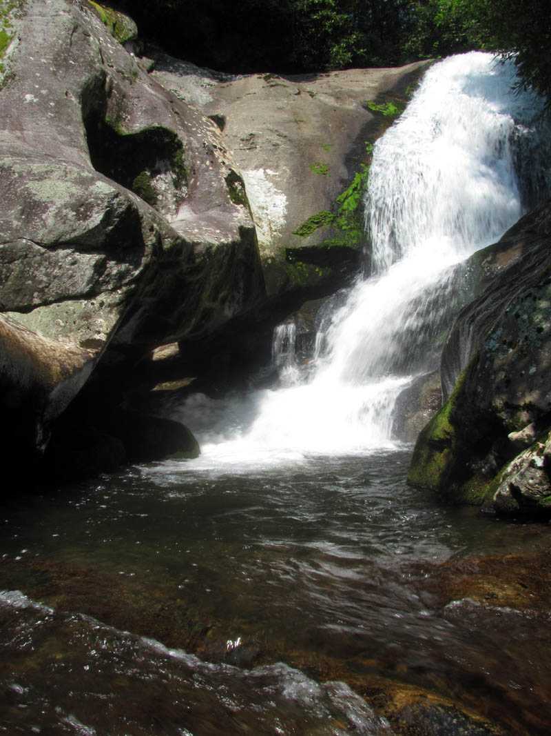
One week ago we ventured up the North Harper Creek gorge in search of the Chestnut Cove Branch Falls and the North Harper Creek Falls. We did find the former but due to reasons you can read about in the previous blog, we did not make it to the North Harper Creek Falls. Approximately one week later, Dave, Lou and myself made another trip back to the North Harper Creek to see those falls. This time we would take a much shorter route starting on FR #58 where trail #266 begins and went down the creek until we reached the top of the falls. This is a fairly easy trail that skirts the edge of some private property located on the left side of the creek and progresses through a beautiful forest until after about a mile you reach the top of the falls. You will cross the creek three times and pass by a couple of nice cascades along the way. The top of the falls looks almost identical to the Chestnut Cove Branch Falls except MUCH LARGER!! It is a very wide, open rock face area with a 200 foot cascade. If it is dry you can easily walk down the left side of this (looking down from the top) and make your way down the various levels of this enormous cascade however, the water does change course and move over to the left side (looking down) and to get down to the lower sections you will have to go back into the woods and take the trail further down to get around it but can then access the lower parts and the top of the vertical falls there.
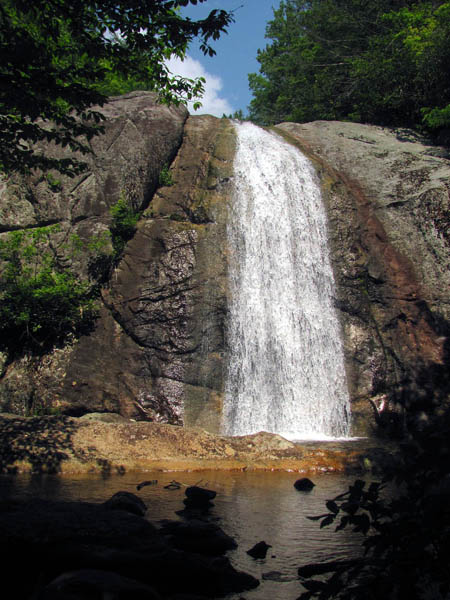
The 40 foot vertical part of North Harper Creek Falls
(more…)
Posted on 12 July '12 by RAT, under RATtreks. 1 Comment.
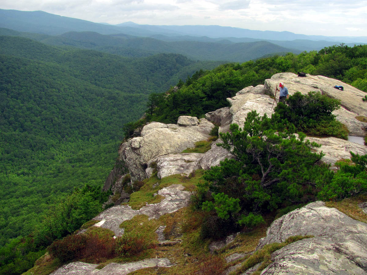
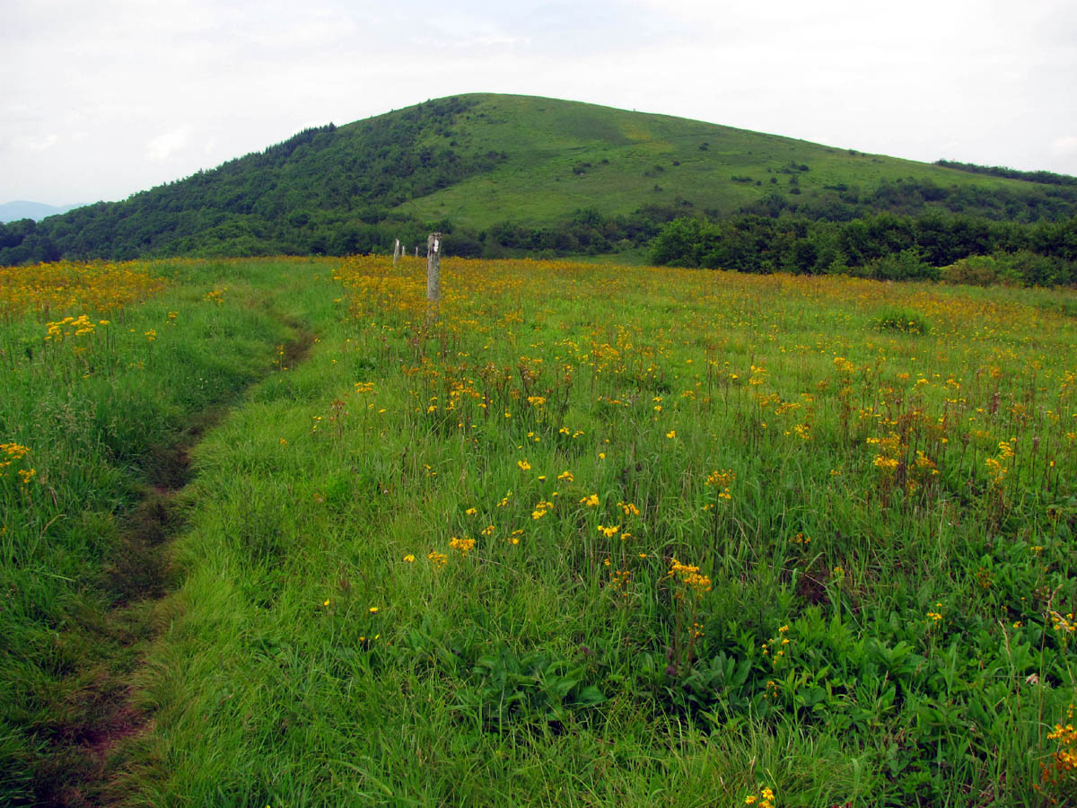
With a very early start to this year`s Spring / Summer season, with record breaking warm temps, and a substantial amount of rainfall, the weed whacking time came early this year. It was still the usual time of mid June before we could make it to my trail section on the A.T. so the weeds were growing exceptionally well. Luckily my son Tyler (right side of picture) agreed to help me out again this year plus as an added bonus, our friend Bol’Dar met us at the end and had cut the weeds all the way from Spivey Gap to High Rocks. Since we stopped cutting around High Rocks, this worked out perfectly. Tyler and I met Doug Corkhill (left side in picture) at Spivey Gap around 9:30 am where we left my car and rode with him to the top of Big Bald where we discovered the key would not work on the locked gate. This was not a big deal for us, however, for Doug it did complicate things as he had brought a push mower to cut the trail across the grassy part just North of the bald and a weed eater to go from the woods on to the shelter and out the ridge to the top of Little Bald where my section starts. This meant he had to push the mower the extra distance down the road just to get to the trail. After that he would have to return it all the way back to the truck and then carry the weed eater in and cut the rest of the trail. To make matters worse, the mower did not want to start at that altitude. We could see him struggling with it as we looked back from the top of the first hill before we got out of sight. We later learned from a Northbound hiker that after some strong words and more pulling on the start cord that it did finally start and he was able to complete the task which was good news indeed.
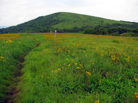
Big Bald
(more…)
Posted on 7 July '12 by RAT, under RATtreks. No Comments.
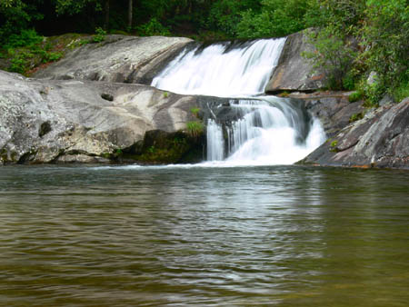
After last week`s adventure to the Huntfish Falls on the North side of FR #464 which took us down into the gorge where the Little Lost Cove Creek is located, it was decided that this week we would go down the South side to the gorge where the North Harper Creek is located. There are numerous falls located in that area plus the Mountains To Sea Trail also covers part of it along with many other intersecting trails making unlimited loop hike possibilities. Dave submitted his idea for a loop hike to the planning committee which was approved so we ended up parking at the trail head where Trail # 239 and Trail #271A is located. On the way we saw a Doe and her newborn fawn (not quite a day old) cross the road in front of us. The fawn kept falling down as his new legs were not working so well yet ! After parking at the trail head, we would walk a short distance down the road (East) to find an unmarked trail that you can almost see from the vehicle which we would take down to the creek about a mile below where we would pick up Trail #266 which is the trail that runs beside the creek in the bottom of the gorge. This unmarked trail was easy to find but is only a faint trail with an old sign post that had the number 39 sprayed on it in faded orange paint.The trail is on some maps and was shown to go straight down the ridge and appeared steep on the map but ended up being a pretty good trail with only a few minor trouble spots. It was a quick, efficient way to get to the bottom of the gorge and trail #266 which was about a mile below the North Harper and Chestnut Cove Br Falls and about a quarter mile above the MTS Trail intersection. It did not take long to reach the bottom where we had to cross the creek to find trail #266 where we took a right and proceeded upstream on a very nice trail through some beautiful ferns towards the waterfalls.

Chestnut Cove Branch Falls (NC)
(more…)
Posted on 4 July '12 by RAT, under RATtreks. 3 Comments.
On June 7, 2012 my waterfall crazy friend Dave Aldridge invited me to go along with him to a waterfall in North Carolina called Huntfish Falls. It’s not that we have ran out of waterfalls to see here in TN (well Dave probably has) but due to low water levels and other issues, we have decided to start exploring the multitude of falls that North Carolina has to offer. We are fortunate to live so close to this area with only an hour + drive to reach them, and there are several waterfalls all very close together that one can see more than one on each trip. All are very nice and Huntfish falls are no exception. They are located in one of the many gorges just North of the Linville gorge on the Little Lost Cove Creek. We left Hairnt-quarters around 8:30 am and reached the trail head around 10:30 am. I noticed the circular white blaze on the sign and the trees along with the yellow blazes but I would not learn until later that we were actually hiking on the Mountains To Sea Trail.
Huntfish Falls (NC) Photo by Dave Aldridge
(more…)
Posted on 26 June '12 by RAT, under RATtreks. 2 Comments.


 My name is 'RAT' and I love the mountains and waterfalls of the East TN. area where I live and I hope you enjoy this blog about my outdoor adventures.


