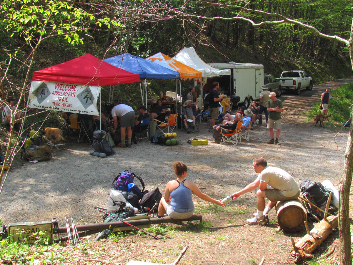
This year was the 25th annual celebration of the Appalachian Trail that as of 2012 has been going right through the center of Damascus, Virginia for 75 years. The festival started back in 1987 to celebrate the 50th anniversary of the trail going through what is known as ‘The Friendliest Town On The Trail’. Thru-hikers attempting to hike the entire length of the trail are in this area about this time of year and they are joined by thousands of other hikers who have either hiked the trail in previous years or wish they could hike it or are friends with someone who has. This year there were about 20,000 people who filled the small town of Damascus which has a population of about 1,000. This was the 22nd year since I have been attending the event since 1990, only having missed one or two years during that time. I have many friends who live there and even more friends who I only get to see there during this time of year so for us and I am sure many others, it is more like a hiker family reunion. This year there were a few of us that could not make it and they were certainly missed and we hope they can find a way to get there next year but due to the great distances that must be traveled along with the high cost of gas, then add the hard economy, it is understandable why some could not make the trip. We did make some new friends this year that I am sure will be coming back for years to come.
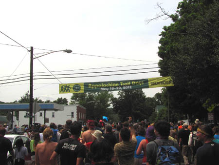
Banner across the main street through town as the hikers pass under it during the hiker parade
(more…)
Posted on 21 June '12 by RAT, under RATtreks. No Comments.
Another annual hiker’s feast has came and gone at Brown Gap and what a grand time it was ! This was the 21st one of its kind that has been done there since it started in 1990. There was at least 50+ thru-hikers that were lucky enough to be in the right place at the right time whom most of them ended up staying the entire weekend to enjoy the mass quantities of assorted foods, fruits, snacks, and drinks that were provided for them. This is not your average ‘hiker feed’ that is typically found along the Appalachian Trail but rather an upgraded and highly refined feast that is the largest and longest running trail magic ever found in one spot. Details on its origins can be seen in a previous blog here. It is always held in late April approx. 3 weeks before the Trail Days celebration which is about how long it takes the average hiker to hike from Brown Gap to Trail Days in Damascus, Virginia.
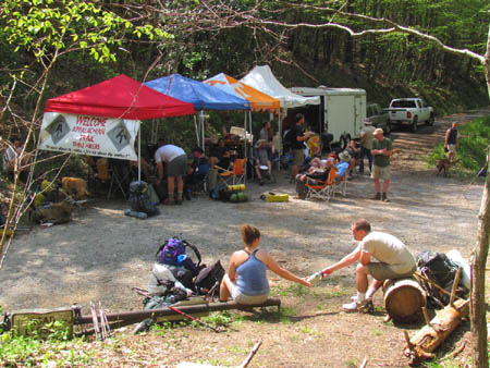
Four Ring Hiker Circus ?
(more…)
Posted on 13 June '12 by RAT, under Uncategorized. No Comments.
I have been awhile in getting this one posted as it has been a very painful process. I was devastated when I heard that one of my closest friends had left this world at such an early age, especially under the circumstances of how it occurred. Stevie was a great person, a very caring and giving human being who would have given anything he could to anyone who asked. It was perhaps this endearing quality that led to this tragic event. My heart will always be sad from this loss until we can one day meet again. My heart goes out to the family and multitudes of friends that Stevie had, as anyone who ever met him, loved him. I will always remember the good times we had together especially each time I play my red Fender Telecaster that Stevie arranged for me to buy from his dad. R.I.P my dear friend, until we meet again on the other side.
In loving memory of Stevie ‘Hale Hound’ Hale.

Stephen 'Hale Hound' Hale
Posted on 5 June '12 by RAT, under RATtreks. No Comments.
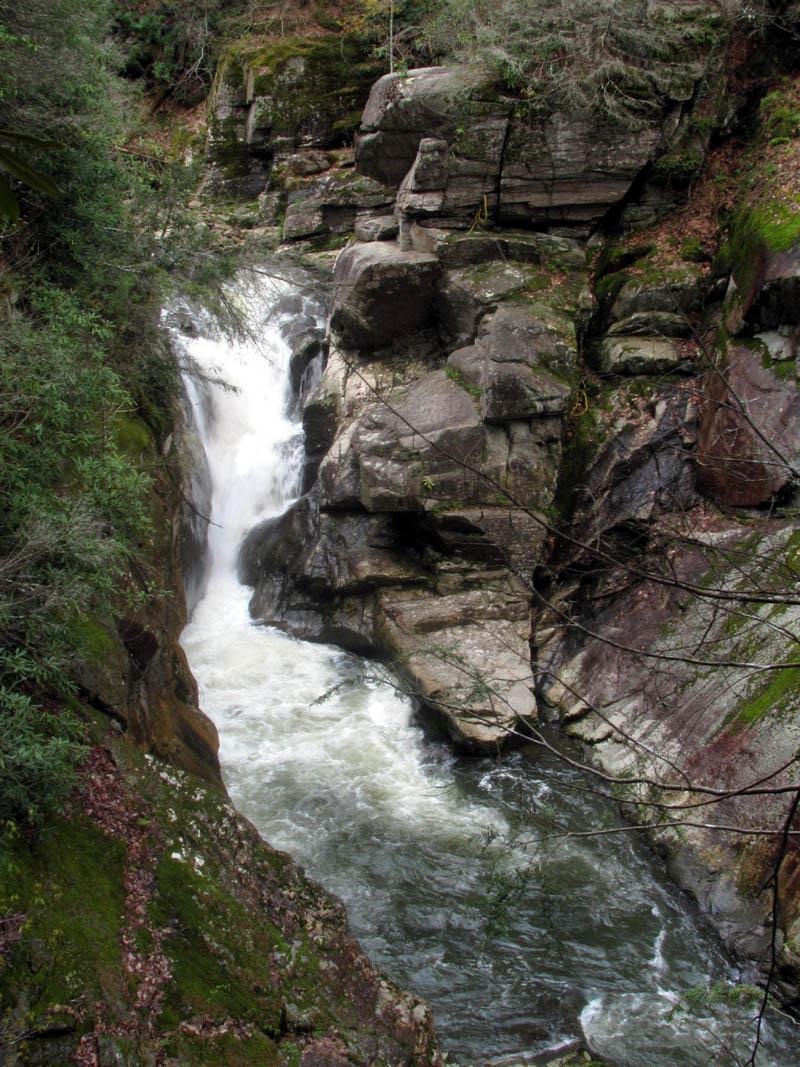
I am usually unable to hike on weekdays due to my having to work nights but ever since our last trip to the Upper Wilderness Falls in Feb. 2012, our waterfall crazy friend Dave Aldridge has been wanting us to take him there not only to see them but so he could measure their height as well. The opportunity for this came on Thursday, April 25, 2012. After meeting up with Dave and Bol’Dar at Hairnt Quarters around 9 am, we were at the Longarm Branch trail head and hiking past the Lower Longarm Branch Falls by 10 am. It was a cloudy day to start out but we knew from the forecast that this would soon burn off and become too sunny for any quality waterfall photo`s but I was glad to be out enjoying Nature anyway and besides, I got some fair shots on our last trip here and I am sure we will be coming back here again in the future as it is such an awesome place. The water levels were surprisingly high so we were excited as we passed the lower falls and made our way to the first of many creek crossings. The numerous small falls and cascades found along the Longarm Branch were as beautiful as ever as we made our way up the rocky hill towards our first stop which would be the Upper Longarm Branch Falls.
Upper Wilderness Falls (Photo by Dave Aldridge 4-26-2012)
(more…)
Posted on 31 May '12 by RAT, under RATtreks. No Comments.
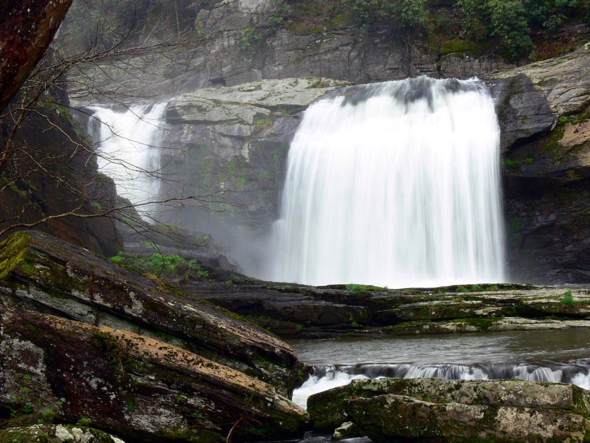
Ever since the Appalachian Trail was relocated in the Buck Mountain area (between highway 19E and Dennis Cove Road) a few years ago, I have been wanting to hike it but, have just not made it a high priority on ‘the list. I have been on some parts of it when going to the Jones Falls and Splash Dam Falls from Elk River Falls (Big Falls) recently but have yet to walk the whole thing. Although I still have not done that, I did go with my hiking friends Dave and Bol’Darto see the Mountaineer Falls and new shelter located there on April 14, 2012. It was a bright sunny day, not conducive for waterfall photos but was a great day to be in the woods nonetheless. We allowed Dave to be our leader on this day as he had already been there and knew a nice shortcut down to the shelter and waterfalls from the old Walnut Mountain Road where a nice old forest road leads quickly down to the AT not far from the shelter. It did not take long at all before we found ourselves there, where we met a long distance Southbound hiker from New York City. Although the water levels were not at flood stage or anything, they were slightly higher than normal so the small falls located right along the trail there were enjoyable.
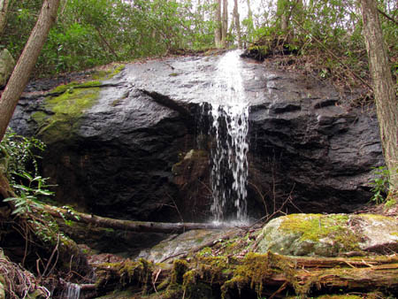
Mountaineer Falls
(more…)
Posted on 17 May '12 by RAT, under RATtreks. 2 Comments.
For many years I have heard about folks going to Twisting Falls and Compression Falls but when I see their pictures they are all the same waterfall. I will attempt to clear up this confusion now as they are definitely two separate and very different waterfalls. The most popular and more known falls are the Compression Falls and I must assume that a lot of the confusion comes from being incorrectly labeled as Twisting Falls on any maps you will find on this area. (I am told they got their name from a boater who compressed his spine when going over the falls in a canoe) In reality, Twisting Falls is a good quarter mile or more up river above the Compression Falls and are MUCH harder to get to. They are well known to the rafter`s of course and they are NR (not runnable) and they have to ‘portage’ (rafting term for maneuvering boats from one body of water to another or around impassable objects by using ropes, etc) the boats around by rigging up ropes and such to get around the falls so they can continue downstream. Considering the fact that these fearless water rats can plunge their boats straight down such things as the Elk River Falls (Aka:Big Falls located further upstream) and the Compression Falls, goes to show just how wicked the Twisting Falls are. On this trip, we set out to find the best way to get to these falls on foot and capture what pics we could get for your viewing pleasure.

Compression Falls (Photo by Dave Aldridge March 2012)

Twisting Falls (Photo by RAT April 3, 2012)
(more…)
Posted on 10 May '12 by RAT, under RATtreks. 3 Comments.
Bol’Dar and myself recently discovered the well hidden location of the Upper Dick Creek Falls only a week ago, but once my waterfall crazy friend Dave Aldridge found out about it, he and Lou just had to go back. I say ‘go back’ because they had went just a few days after we found them and even with some detailed directions from me and a GPS coordinate/Garmin, they were still unable to find the falls. This should give you some idea of just how hard these falls are to find. When I heard their mission had failed, I agreed to take them there the following weekend. Even though we had just been there the previous weekend, I was all to happy to go back as it is an awesome place and an incredible looking set of waterfalls. Unfortunately Bol’Dar could not go along on this trip which is too bad because we chose to go in the easy way from the Limestone Cove side and we ended up finding another route to the upper falls. The first major obstacle would be to get across the high water of North Indian Creek. It was flowing way too fast and much too deep for wading across it and would take a very high clearance vehicle with really big tires to drive across it although it is easily passable when the water levels are lower like in Summer time. This problem was solved easily by parking just down the road a ways at a large pull off where a concrete bridge crosses the creek to a large field. This is private property and we did try to find its owners to get permission but it seems a bottled water company now owns it but was unable to start a company there but there is a new bathroom built towards the end of the property with water and power so I am not sure what the future holds for it but it seemed ok to access the Dick Creek area by crossing it and entering into the woods on the left side where you have to cross Dick Creek to get to the forest road that comes in from Limestone Cove road.
Upper Dick Creek Falls
(more…)
Posted on 25 April '12 by RAT, under RATtreks. 2 Comments.
It`s that time of year again ! Time to do a walk-through of my section of the Appalachian Trail (Little Bald to Spivey Gap) to check for blow-downs that will require a chainsaw and to clear any debris and limbs from the winter season. I also clean out the water bars at this time. I try to go as early as weather permits which is usually in mid to late February but, sometimes the mountains still have deep snow then so it must wait until a later time. This year we did not get much snow and it is unseasonably warm but it was still early March before a trip could be arranged. To make things easier on myself, I always wait until my friend Doug Corkhill goes to his section (Big Bald to Little Bald) which is just South of mine as he graciously goes out of his way to drive around to Spivey Gap and pick me up where we leave my vehicle and proceed to drive his truck to the summit of Big Bald (as we have access through Wolf Laurel and a key to the gate) whereas I can walk his section over to Little Bald and then downhill one way on my section which is 5+ miles in itself. This makes my total miles to be around 7+ and eliminates hiking up the very steep 5 miles of my section and then having to hike back after working all day the way I did it for years in the old days.

Big Stamp area looking towards Little Bald
(more…)
Posted on 18 April '12 by RAT, under RATtreks. No Comments.
I have been going to the Dick Creek area for well over 30 years now and recall many trips there for off-roading, hunting, camping, and to visit the Dick Creek Falls (lower) which I think is one of the prettiest waterfalls in East Tennessee. Back then we called it ‘Dixie Creek’. I have heard many times of an Upper Dick Creek Falls and despite deer hunting in that hollow many times, I had never seen any significant waterfalls there. Of course back then I was not looking for waterfalls. After recently seeing a picture of the upper falls and hearing of many failed attempts by others to find them, I took it as a challenge to myself and my friend Bol’Dar to locate these elusive falls once and for all. This was accomplished on a Saturday, March 3, 2012.
Upper Dick Creek Falls
(more…)
Posted on 16 April '12 by RAT, under RATtreks. 1 Comment.
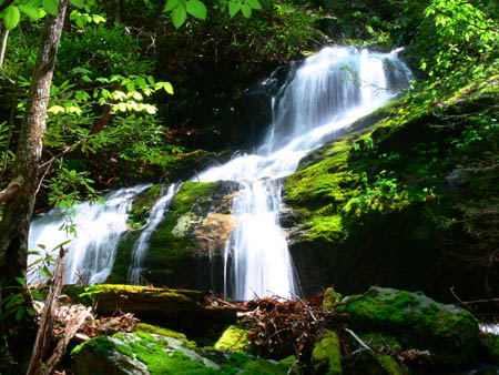
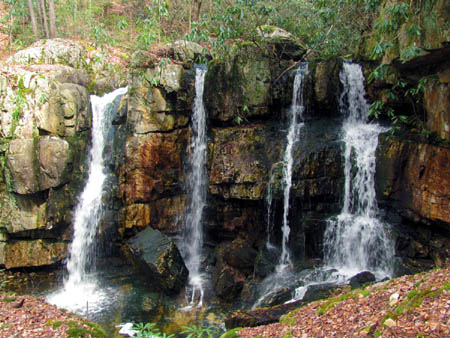
The Wilderness Falls were discovered by my friend Bol’Dar and we were recently given the privilege of naming these falls when they were listed on the Official Tennessee Landforms directory of Waterfalls. They are well hidden with no trails leading to them which is obvious by the fact that we have explored that area for well over 20 years and never found them until recently! They were first called ‘The Triplets’ by Bol’Dar as there is a lower falls, a much larger middle falls, and an equally large upper falls but it was later decided that we would call them all ‘The Wilderness Falls’. We had been to the lower and middle falls back on 11-29-2010 when we took Dave there to get a GPS coordinate for them so they could be listed with Landforms but, we did not get to the upper falls that day as that requires either some very serious climbing or better yet, serious descending to them from above. I had only seen a glimpse of a small part of them from a distance when I climbed up the unbelievably steep right side of the middle falls on my first trip there so, we decided to go to the upper falls from the top and climb down them all on our way out in order to document them and enjoy their immense height and beauty. I was excited as this would be my first time to the upper falls up close.

Upper Wilderness Falls
(more…)
Posted on 6 April '12 by RAT, under RATtreks. 1 Comment.


 My name is 'RAT' and I love the mountains and waterfalls of the East TN. area where I live and I hope you enjoy this blog about my outdoor adventures.


