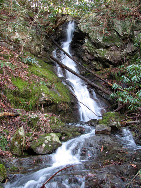
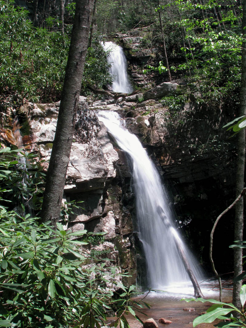
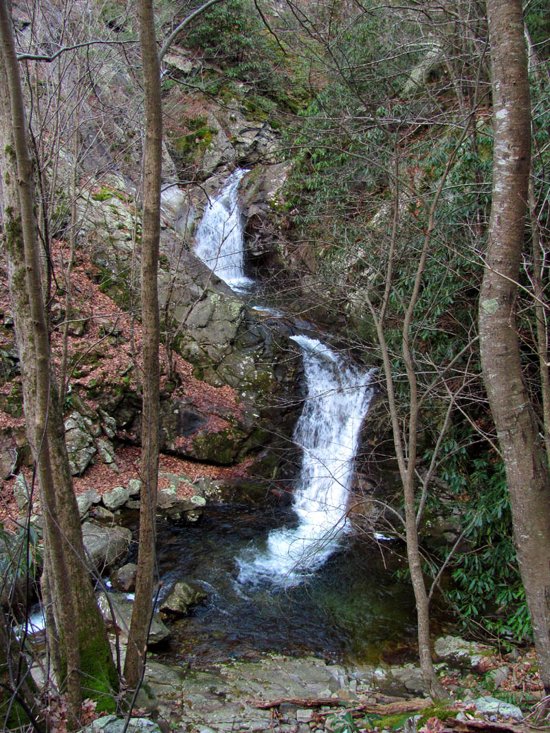
On Saturday April 30, 2011, my avid waterfall enthusiast friend Dave Aldridge, offered to take us to Gentry Falls, an awesome double falls located in Johnson County, Tennessee. He had previously helped the Forest Service do some trail work there by painting new blazes on the trail leading to them, so he knew how to get there. I had been wanting to go see these falls for quite some time now so I looked up some information on the internet which gave some interesting background of the history of the the creek and falls, and the surrounding area but the only information I could find on the current route to the falls was actually incorrect. If you believe what I read about the level of difficulty in getting to these falls, you would probably not even go !! It was a really nice trail that was not hard at all. Dave picked us up at Hairnt-quarters that morning and we made the hour long trip through Elizabethton and Mountain City and then towards Damascus, Va. until we reached the turn off at Laurel Bloomery. We had to wait on some cleanup crews that had the highway blocked just before Mountain City as they were cleaning up some massive storm damage caused by the recent tornadoes that had passed through this area a few days earlier. After making a slight miscalculation and going up the wrong road, we quickly located the right route and it was not long before we were parking at the trail head. It was a sunny and warm day, not exactly conducive for taking photographs of waterfalls, but a wonderful Spring day to be in the woods nonetheless.

Gentry Falls
(more…)
Posted on 3 August '11 by RAT, under RATtreks. 1 Comment.
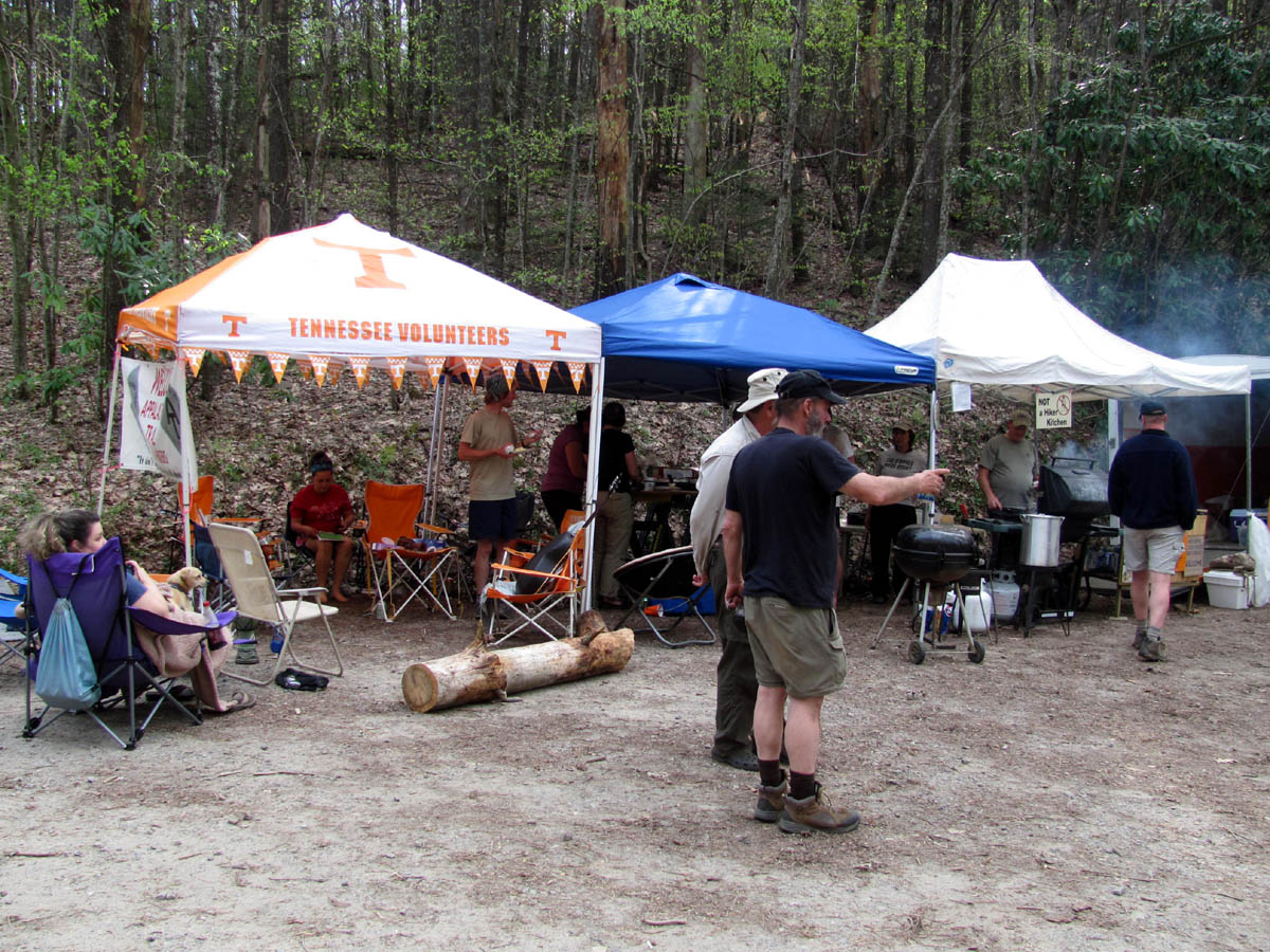
It’s hard to believe that this event has been going on for 20 years now, but as hordes of hungry hikers descended down into the gap they were greeted by sights, sounds, and smells, of other hikers being provided with mass quantities of assorted cold drinks and a vast array of foods. Of course this is only a generalization of what goes on at this event as there is much more to it than just food and drinks. Before I get to those details, let me provide some background of what this event is for, its location, and just how it all began.
The Early Years !
Brown Gap is located along the Appalachian Trail in a remote area just North of the Great Smoky Mountains along the Tennessee/North Carolina border. It is approximately three miles South of Max Patch. A small gravel US Forest Service road makes it possible for vehicles to access it (if you don’t mind going up a really steep hill). Each year hundreds of hikers attempting to ‘thru-hike’ the entire trail from Georgia to Maine (2,176 miles/ 14 states) will pass through this gap, but only certain ones will be there at the right time to be lucky enough to be a part of the largest ‘trail magic’ event found anywhere on the trail. The timing of the event is around the last weekend in April, about 3 weeks in advance of the very well known celebration called ‘Appalachian Trail Days‘ which is held in early to mid May in Damascus, Virginia. The significance of this is that it will take the average hiker that long to hike from Brown Gap to Damascus.

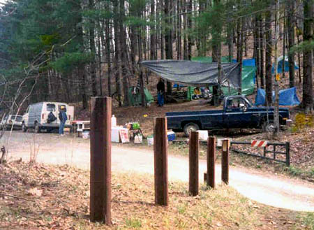
Brown Gap Hikers Feast 2011
The reason this location was chosen is because it is at a point on the trail where the hikers are not very close to any easily available re-supply points. Having just hiked the 71 miles across the rugged Great Smoky Mountains National Park, with no stores or postal services and still having over 23 miles to go to the next town of Hot Springs, NC, their food supplies are running low. Not to mention that after a week of hiking with nothing by dehydrated foods and water, along with burning up to and beyond 5000 calories per day, that their need and cravings for cold drinks and real food are getting strong ! Although they would surely make it to Hot Springs without any assistance, there is definitely a need for some random acts of kindness there which gave birth to what is now known more commonly as ‘trail magic’.
(more…)
Posted on 4 July '11 by RAT, under RATtreks. 2 Comments.
You may remember our last trip to the Devil Fork area in Clarks Creek back in Nov. 2009 when we encountered much opposition on our way in from the top due to the extensive pine bark beetle damage and the lack of foot travel there in the 20 or so years it had been since we were there. Since that time we have been researching alternative routes to get into the Devil Fork Valley, hoping to find an easier, more direct route although, we knew due to the extremely steep and treacherous terrain, it would not be an easy affair. After a few re-con trips by Bol’Dar and much map studying by the two of us, we finally decided on what we thought would be the best and safest route. This was to be determined on 4-3-2011 when we set out to test our hypothesis.
Lilybeth Falls
(more…)
Posted on 15 June '11 by RAT, under RATtreks. 1 Comment.
Ever since my first trip to Buckeye Falls some 30 years ago, I have wanted to stand on the highest part of Chigger Ridge in order to get the ‘Big Picture’ of Buckeye Falls in their entirety. We managed to get a really good close up of the entire falls from the adjacent left side ridge when they were frozen back in March of 2010, but after our recent trip to the base of the falls on February 26, 2011, I knew we would soon be fulfilling our quest to the vantage point on Chigger Ridge. This was finally accomplished on March 12, 2011.
View of Buckeye Falls from top of Chigger Ridge
(more…)
Posted on 6 May '11 by RAT, under RATtreks. 5 Comments.
It`s that time of year again, after the snow finally melts enough to get up to the high country to do a walk through of my trail section to see what work needs to be done in preparation for the herds of thru-hikers that will soon be be trekking Northward. I usually try to get on the section in February but this past Winter has left plenty of snow so this was the earliest I could get up here. Many early birds have already came through. It seems they get earlier each year with some that left Springer Mountain Georgia as early as January 1st. I met my friend and fellow trail maintainer Doug Corkhill at Spivey Gap where I left my car and rode with him to the top of Big Bald where his section starts. It was a beautiful morning and we stopped at the Big Creek Falls on the North Carolina side to take in the beauty that the high water levels had to offer. I could see the incredible water flowing from the Spivey Falls on my way up but did not have time to stop and get any pics. I would try and check them out on my way home if I got out before dark. It is nice to be able to see some cool waterfalls when going on a trip of any sorts.

Big Creek Falls (North Carolina)
(more…)
Posted on 29 April '11 by RAT, under RATtreks. 1 Comment.
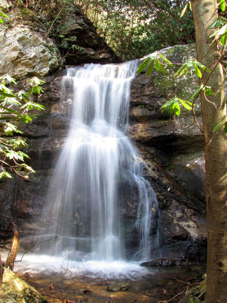
The Superbowl of waterfalls. Aside from the trip we completed there back on March 6-2010 when we climbed the left side ridge in order to get a view of the entire falls (when it was frozen), it has been at least 20 years since my last trip to the base of these falls,,,until now. After much planning (as this is not a waterfall you can just decide to go to on the spur of the moment due to the distance and difficulty of the terrain) we chose to make the trek on Saturday, February 26, 2011. It was also due to the current water levels being high, warmer temps with no snow and ice but no snakes!, and the schedules of those who were going. Despite many trips there over the years, I can’t recall ever being there when this amount of water was flowing so, I was looking very forward to this expedition although I knew it meant hiking in wet boots the whole time. We all met at Hairnt-quarters early, around 7:30 am as an early start is a must for this adventure as it is not the place to be in the dark and you want to have as much time there as possible. We arrived at the trail-head and was on the trail by 8:30am. You could see the first of many creek crossings from the vehicle but with the high water levels that day, it looked more like a river !
Buckeye Falls
(more…)
Posted on 19 April '11 by RAT, under RATtreks. 1 Comment.
My hiking and fellow waterfall loving friend Dave Aldridge has been wanting to go see the Simmons Branch Falls for quite sometime now and had recently managed a trip to the lower falls but, was unsure on how to get past them to the middle and uppers as it does seem an impervious task. We decided to go on a warm, sunny, Wednesday in late February while the water levels were fairly high which makes for much better waterfall viewing and photographing. We left Hairnt-Quarters around 9 am stopping for breakfast at a local diner in Unicoi before continuing on to Bumpass Cove. The gate is closed during this time of year so we had to park in a way as to not block it and yet stay off of any private property that surrounds the entrance to the forest there. It did not take long to get to the lower falls and to my surprise there was actually water flowing in what is called the ‘feeder falls‘ to the left of the lower falls. (don’t ask me why they are called that) Since Dave had recently been to the lower falls and did not need to climb over to them to get photo`s, and wanted to begin the arduous climb to the top, I showed him the route to take while I went over to the base of the lower falls and setup my tripod to take some pics. The last time I was here, there was no where near this much water and the time before (my first time actually) it was frozen solid. I had no longer set up and taken a few pics when I heard Dave hairnt at me from the top. I was glad he had made it safely as it is a steep climb with a rock cliff to negotiate at the top. I finished my pics and soon joined him up there. After that climb I had to rest before continuing on so I took a pic of the falls from the cliff above them while catching my breath. Looking down off this rock is very cool and it is a long way to the bottom where you just came from.
Lower Simmons Branch Falls
(more…)
Posted on 31 March '11 by RAT, under RATtreks. 1 Comment.
On February 7, 2011 , Alvis L. Kinney aka: ‘Pawpaw’ passed from this world to hike that great trail on the other side. He was loved by everyone who met him and was one of my very best friends for the past 19 years and we will all miss him more than words can describe. Having served during Korea and surviving the attack of Pearl Harbor, he went on to hike the entire length of the Appalachian Trail several times, the last time earning him the title of the oldest man to thru-hike the trail. He loved hiking and the many friends he made while doing so. He was was a loving father, grandfather, and husband and is now back with his beloved wife Lillian who left this world before him. He will be surely missed by all until we can meet again someday.
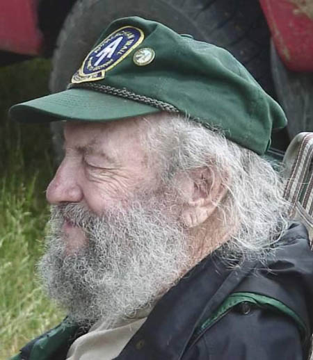
Alvis L. 'Pawpaw' Kinney
March 6, 1917 to February 7, 2011
A million times we’ve needed you,
and a million times we’ve cried.
If our love alone could have saved you,
you never would have died.
In life we loved you dearly,
in death we love you still.
In our hearts you hold a special place,
no one else can ever fill.
It broke our hearts to lose you,
but you didn’t go alone.
A part of us went with you,
the day God took you home.
We love and miss you Pawpaw.
Posted on 30 March '11 by RAT, under RATtreks. No Comments.
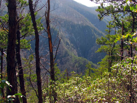
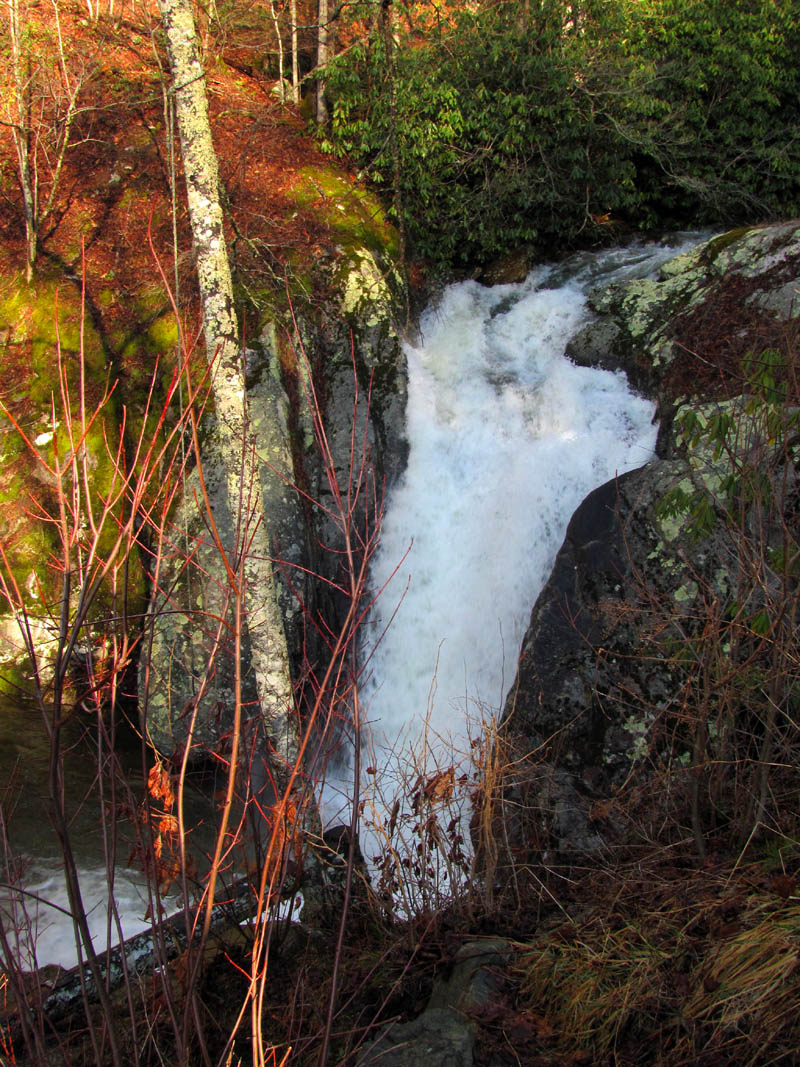
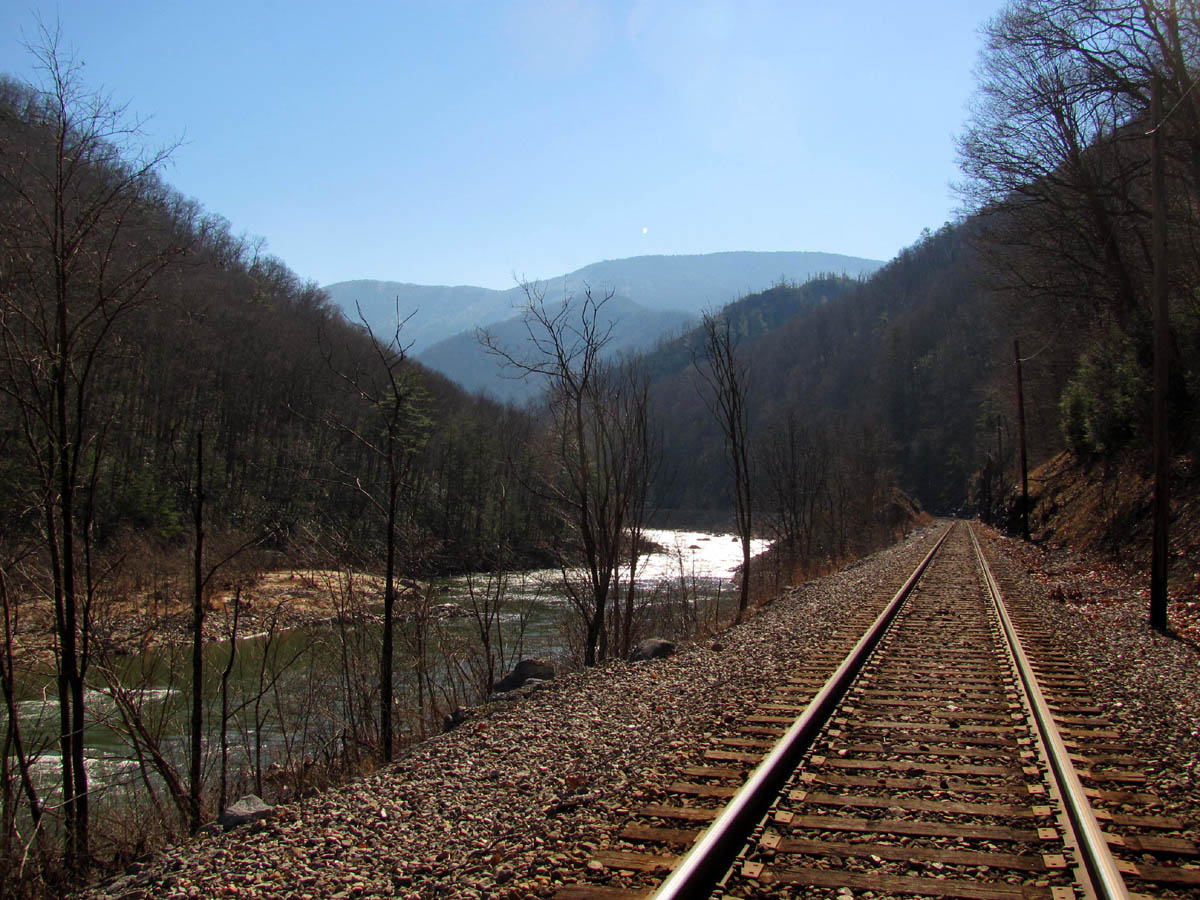
The next trip to the Devils Creek watershed area would come on Sunday, 2-6-2011 on a nice sunny day with believe it or not, no snow ! This time we would start at Unaka Springs near Chestoa and follow the railroad tracks into the Nolichucky River Gorge towards North Carolina. DISCLAIMER: Walking railroad tracks is dangerous and against federal law so do this at your own risk !!! I have so many memories of numerous trips to this area but it has been at least 20 years since I was here last. Not much has changed really, walking the tracks is still dangerous and basically unpleasant other than the incredible views of the river, parts of Unaka, Flattop, and the other mountains that line the steep sides of the river gorge.You can make pretty good time walking the more or less level tracks, perhaps it’s the adrenaline caused from thinking about approaching trains that puts a spring in ones step here ? We were very lucky on our trip in to the gorge as we did not encounter a single train however, this would be made up for on the way out later that evening ! The ducks were out enjoying the morning as were a family group we met coming out. We stopped at one of our favorite old break spots where there is a large rock formation (this pic was taken on our way out) on the river side and where the steep rock sides begin along the tracks just before the sharp blind curve that has to be negotiated before the long straightaway that leads to the NC/TN state line which is where the Devils Creek enters the river. It did not take long at all to hike that 2+ miles and we could soon see the old iron bridge and the sheer rock, cliff-like sides of the entrance to the narrow Devils Creek Valley.

Nolichucky River Gorge
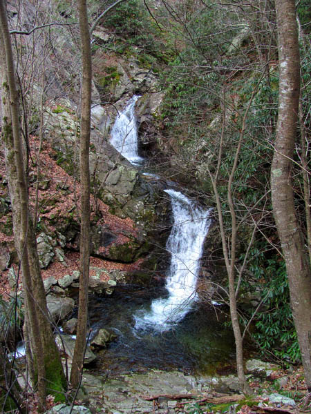
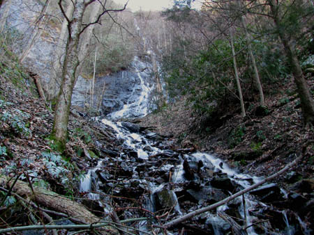
Upper Devils Creek Falls
(more…)
Posted on 28 March '11 by RAT, under RATtreks. 2 Comments.
After several days of warmer temps with much snow melted in the lower elevations, it was decided by my friend Bol’Dar and myself that we would attempt to cross another expedition off our long list of places to hike. This priority being the Devils Creek watershed area located on the TN/NC state line. Leaving Hairnt-quarters around mid-morning we arrived at Spivey Gap shortly after 10 am only to find knee deep snow still there making it nearly impossible to even pull the car off the road ! Luckily it was cold and frozen solid so I managed to drive off into some large truck tracks and park, hoping it would not be sunk to the axle when it melted later that day. I had hoped to not hike in anymore deep snow but it was not to be as there was still plenty to be found in the higher elevations and especially on the North and shady slopes of the mountains. Going North on the A.T. it was not as difficult as it looked as the snow was frozen very solid and we were able to crunch our way across the top of it without issue. There would be a large blowdown right off the bat but the first oddity of the day would be these strange orange plastic things that were fastened to short pieces of reebar sticking up in the ground off to the sides of the trail leading towards Oglesby Branch. Not sure what these were for as there placement was very random. Our first break would be at the bridge crossing over the branch where we recalled stopping at so many times in the years before, back when the Rat > Patrol Hiking Club was in full swing some 20+ years ago. It was covered with deep snow but the sun was shining intensely and it felt good to be in the woods breathing the crisp mountain air.
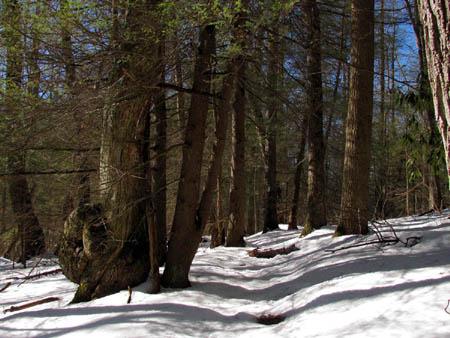
Edge of Flattop Mtn. just before Devils Creek Gap
(more…)
Posted on 28 March '11 by RAT, under RATtreks. 1 Comment.


 My name is 'RAT' and I love the mountains and waterfalls of the East TN. area where I live and I hope you enjoy this blog about my outdoor adventures.


