Elusive ? Yes, elusive. Why, you ask ? Due to their remote location, lack of any real trail, plus many obstacles to negotiate, not to mention the absence of accurate directions which are not readily available, that many are unable to find (or they lack the physical ability to actually make the 7+ mile round trip that feels like 14 ! ) to get to these colossal falls. It is also dangerous and not a recommended trip for the average waterfall visitor. The route is not marked and there are no signs. Personally, I am thankful that they are so elusive and hard to find and that the route is so strenuous as I consider it a sacred place and wish for only those who think of it in that manner to visit there so it will hopefully receive the appreciation and protection it deserves in hopes that it will remain the tranquil, quiescent, unpolluted place it is now.
Buckeye Falls
(more…)
Posted on 22 March '10 by RAT, under RATtreks. 9 Comments.
Second trip this weekend ! HAIRNT !! And a much warmer day with less snow to hike through than the day before. Got a slightly earlier start this time even after oversleeping until almost 1 pm, still there was no answer at Bol’Dar’s (hmmm__ I wonder ?,,,) so once again it was just my son Tyler, and me. After recently hearing talk about waterfalls up Simmons Branch in Bumpus Cove, (pretty sure we always referred to it as ‘Bumpass’ cove !) I decided to go there since it was close and in the lower elevations as there is still a lot of snow in the mountains. It has been many years since I have been in the Bumpus Cove area and there have been some noticeable changes but for the most part it is still just as I remember it. I used to spend a lot of time there over the years for various reasons. We drove right to the end of the paved road then continued a short ways further to where the old forest service road (that goes to Rich mountain and beyond) begins. It is gated this time of year. We had no trouble finding Simmons Branch as it is basically the first hollow on the right.
 rs")
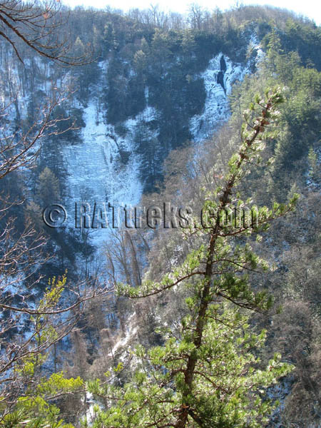
Simmons Branch Falls (lower)
This is an old mining community that at one time had at least 31 mines in operation (maybe more at one time) and was considered to be the largest company in the state of Tennessee back in those days (according to 80 yr old resident Clay Rogers who can remember vividly when they were in operation) mining such minerals as Zinc, Iron, Manganese, and Lead, just to name a few of the popular ones. Although it has been reclaimed, caution should be taken as there are remnants of old mine and air shafts that could be potentially dangerous, so please be very careful if you tread here. There is a visible mine location right at the start of Simmons Branch just after you cross the first creek. More info on all the mines can be found HERE. (make sure to click ‘terrain’)
(more…)
Posted on 27 February '10 by RAT, under RATtreks. 3 Comments.
The Winter That Never Ends
For the last three weeks or more, we have had an abundance of snow on the ground here, and the mountains were getting nightly doses with well below freezing temps which made for some very spectacular photos, however, it has been way too deep and cold for this RAT to leave the hole until now.

Unaka Mountain frozen

Buffalo Mountain frozen
It has been many years since we had a real winter, but this year has broken many records, not only here but all over the country, and seems like it is not going to end anytime soon. However, this past weekend did allow for some much warmer
weather so I was able to get out to the mountains for some much needed exercise and after all, my adventure level was getting a little low! There was still plenty of snow to be found. There was also ample amounts of storm damage to be encountered which makes getting to the destinations difficult, to say the least, and it also somehow takes away a part of the beauty and aesthetics of many of our cherished waterfalls. One in particular, Squibb Creek Falls, has all but disappeared beneath natures recent changes.
(more…)
Posted on 24 February '10 by RAT, under RATtreks. 6 Comments.
Thanks again to some much needed warmer temps, another trip to some magnificent waterfalls was possible. This time due to time constraints (another late start) we went to Red Fork falls which is fairly close by in the Unaka Mountain area and is not that far of a hike to get to. I have not been there in at least 20 years and before that was my first time on New Years of 1966. It was freezing and slick then as I recall my dad falling in the creek while carrying me nearly going over the top of the falls, and this time was no different which made climbing down the falls very treacherous.

Red Fork Falls
After parking at the trail-head on Red Fork Road (also known as Unaka Mountain Road) located 7.8 miles up Limestone Cove Road from Unicoi, it is a mere half mile to the falls (marked with a red dot) but don’t let that fool you because if you do risk climbing down the falls to the lower falls below, you will feel like you have hiked much farther the next day ! It is a matter of holding on to laurels, rocks and stumps as you carefully make your way down and I must advise that many people have been seriously injured here so please use extreme caution especially when it is frozen and slick like it is now.
(more…)
Posted on 3 February '10 by RAT, under RATtreks. 3 Comments.
Another January adventure led us back to the Unaka Mountain Wilderness area, this time up Rock Creek to the many waterfalls that are found there. Another late start on a partly sunny day, not too cold, and no wind blowing when we left Hairnt-quarters, but as soon as we got out of the vehicle you could hear the winds roaring loudly, high overhead. There was no snow on the ground this time due to the recent warmer temps, but we did find some before the day was over. The park is still closed this time of year so we parked at the gate and walked the full length of the park until we reached the Rock Creek Falls trail-head. Apparently this takes you outside the ‘safety zone‘ of the park according to the signs ! I am also glad I did not bring a hang-glider as apparently that is not allowed ! After hiking a short way past some cool fungus and a gnarley tree, we came to the first of four creek crossings. The water levels are still very high right now which is one reason I am going to as many waterfalls as I can but, this makes for some tricky creek crossings, many of which
are done by what we call ‘ninja log walks‘.
")
Rock Creek Falls (upper)
(more…)
Posted on 1 February '10 by RAT, under RATtreks. No Comments.
Finally the temperatures have risen enough to get out on my first adventure of the new decade. I decided to lead an adventure to Dick Creek Falls from the Rock Creek side, along with my son Tyler and good friend Bol’Dar. As usual, we got a late start so we did not leave Hairnt-quarters until around noon. Snow was still visible on the mountains as we drove to Erwin and we hiked on it from the gate where we parked, all the way to the falls and back. It was not deep enough to be cumbersome, except for the ‘shortcut‘ we took on the way back where it was a bit deeper, but we decided we needed some extra adventure anyway! The swimming area in the park was still somewhat frozen.

Dick Creek Falls
(more…)
Posted on 20 January '10 by RAT, under RATtreks. 2 Comments.
Happy Thanksgiving ! ~ This year I took a road trip to spend turkey day with some family / friends in the Cincinnati area. There is nothing like being with the ones you love and seeing friends you have not seen in a long time. There is also nothing like having the opportunity to go see some nice sites and waterfalls along the way. On the way home we took a side trip over to Cumberland Falls State Park to see Cumberland Falls located in the Daniel Boone National Forest just outside of Corbin, Kentucky.

Cumberland Falls
These falls are 125 feet across and 68 feet high and is sometimes called the ‘Niagra of the South’ , Little Niagra’, or Moonbow Falls’. Famous for its ‘moonbow‘ caused by the mist rising from the largest waterfall in Kentucky, creates a unique natural phenomenon that is not visible anywhere else in the Western Hemisphere on a predictable schedule during a time period around the Full Moon. The Falls are situated in such an odd way facing north and flowing north, as to reflect the light of the Moon to make a rainbow like arch, an optical phenomenon called a “moonbow“. The Moonbow can be seen here on clear, strongly moonlit nights. This waterfall is one of a few locations in the world where you can find a moonbow or as other’s have called it, night rainbow, a moon rainbow or lunar rainbow.

Cumberland Falls
(more…)
Posted on 1 December '09 by RAT, under RATtreks. No Comments.
It has been many years since I last visited Millstone Creek Falls and Ramsey Falls, so my son Tyler and myself recently took some time on Saturday, Nov. 21-2009 to see if we could find them and get some decent pics. We got a late start of around 2 pm but the weather was very nice and these falls are located very close to where we live so we knew there should be enough time. We decided to go to Millstone Falls first as they are closest to the road and require the least amount of walking. We drove down to Nolichuckey River and after walking a little ways up the wrong trail (although we discovered a very nice trail up Millstone Creek) we quickly found the right access point and made it to the falls within just a few minutes.

Millstone Creek Falls
With the water levels still high, they looked really nice and were actually larger than I remember them from 20 some odd years ago. After spending about an hour there taking pictures and enjoying the beauty of the area, we made our way back to our vehicle at the river and proceeded to drive to our next destination of Ramsey Falls.
(more…)
Posted on 29 November '09 by RAT, under RATtreks. No Comments.
After our trip to some of the lower Devil’s Fork Falls last Monday (Nov. 9, 2009) including Pine Ridge Falls (lower Devil’s Fork falls) and Josiah Falls (middle Devil’s Fork falls) it has been heavy on my mind to go back to the elusive upper Devil’s Fork Falls (Lilybeth and Devil’s Slide ) as I have not been there for nearly 20 years. Knowing that the water levels are still high from the recent tropical depression ‘Ida’, and that the warm weather might not last much longer this year, I decided to make the pilgrimage back to the place where the ‘Rat > Patrol’ clan used to make frequent trips to what we called the ‘waterfall tour’.
We used to start in Sill branch to see the lower falls there, then the upper falls, and the many other falls and cascades above those, all the way to the top of Rich mountain. We would traverse it stopping to eat lunch at one of the ‘California Fields” enjoying the brilliant views of Sampson and the surrounding mountains, then move down our secret shortcut trails to Devil’s Fork.
I knew I was no longer in physical shape to make such an arduous journey in one day (also knowing we would be getting a late start) so I opted to hike up Longarm Ridge trail to Devil’s Fork trail and go down from there. Although I expected the trail to be overgrown, little did I know that parts of the old Devil’s Fork trail would be devastated from pine bark beetle damage and would cause us much delays and strenuous to extreme hiking in order to reach our destination, as many parts of the old road trail were completely impassable.

Lilybeth Falls (Upper Devil's Fork Falls)
(more…)
Posted on 21 November '09 by RAT, under RATtreks. 1 Comment.
A recent hike on 11-9-2009, with my friend Bol’Dar, to the Devil’s Fork Creek area of Clark’s Creek in the Sampson Mountain Wilderness area, brought back some fond memories of the old days when we used to explore this place on a regular basis. Of course we never knew the first set of falls were actually called Pine Ridge Falls and certainly did not call the falls beyond that Josiah Falls. To us they were all just Devil’s Fork Falls: lower, middle and upper. There are also another nice set of falls above Josiah that we call the upper falls but according to my research they are called ‘Devil’s Slide’ and ‘Lilybeth’ falls. I plan a trip to them soon as I have more time.

Pine Ridge Falls
To see the next set of larger falls beyond the Pine Ridge Falls you need to take precaution as crossing these (which is done by carefully climbing the rocks across the right side) is a bit dangerous. After that it’s not so bad following Devil’s Creek to the next set of falls (Josiah) but it is hardly traveled anymore so the trail is overgrown and can be hard to find so the basic rule of thumb is to follow the creek as best you can.

Josiah Falls (Devil's Fork)
There is another very nice set of falls above these however reaching them is not for the inexperienced hiker. I recommend coming down from the top of Rich mountain through the Devils Fork gorge to go down all of the falls rather than climb them but beware as it is grown up since when we used to do this all the time. To see more photos of these falls please visit my photo gallery and look for the waterfalls album.
Posted on 10 November '09 by RAT, under RATtreks. No Comments.


 My name is 'RAT' and I love the mountains and waterfalls of the East TN. area where I live and I hope you enjoy this blog about my outdoor adventures.


