


The Wilderness Falls – 2-23-2012
The Wilderness Falls were discovered by my friend Bol’Dar and we were recently given the privilege of naming these falls when they were listed on the Official Tennessee Landforms directory of Waterfalls. They are well hidden with no trails leading to them which is obvious by the fact that we have explored that area for well over 20 years and never found them until recently! They were first called ‘The Triplets’ by Bol’Dar as there is a lower falls, a much larger middle falls, and an equally large upper falls but it was later decided that we would call them all ‘The Wilderness Falls’. We had been to the lower and middle falls back on 11-29-2010 when we took Dave there to get a GPS coordinate for them so they could be listed with Landforms but, we did not get to the upper falls that day as that requires either some very serious climbing or better yet, serious descending to them from above. I had only seen a glimpse of a small part of them from a distance when I climbed up the unbelievably steep right side of the middle falls on my first trip there so, we decided to go to the upper falls from the top and climb down them all on our way out in order to document them and enjoy their immense height and beauty. I was excited as this would be my first time to the upper falls up close.

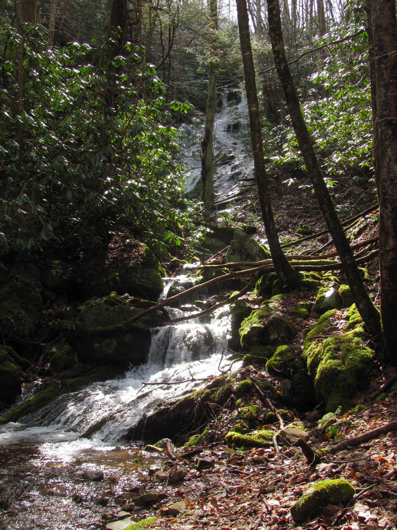
Upper Wilderness Falls
It was a bright sunny morning (which would not be good for picture taking) as Bol’Dar and I started our journey at the Longarm Branch Trail-head passing by the Lower Longarm Branch Falls around 10:30am or so. There was an ample supply of water flowing due to the recent rains so we anticipated all the falls to be very nice on this day which is always a plus. Although it makes the many creek crossings more difficult, it is well worth it to have the extra water which makes multiple cascades and waterfalls much nicer. Each time we crossed the creek, I couldn’t help but remember back 20 years ago when I used to drive my VW bug up this road all the way to Bumpass Cove not to mention the many motorcycles, jeeps, and trucks over the years before the floods washed all the bridges and drainage pipes out.

Lower Longarm Branch Falls
We were in somewhat of a hurry to get to the top of the Upper Wilderness Falls before the light went flat but, we could not resist stopping at many of the beautiful cascades and small falls on our way up the Longarm Branch Trail. Despite all the stops, it did not take too long to cover the 2 miles up the rocky hill to the base of the Upper Longarm Branch Falls which were flowing very well compared to the last couple of times I was there. We found a ‘fireball‘ wrapper laying in the road on the rocky hill just before the falls,, I had to wonder, could it be ?? Nahh, surely not ! We ate some lunch at the falls and tried to get some pics during some passing clouds that were few and far between and with the sun shining right into our faces there wasn’t much we could do about that. We continued on the trail which goes above the falls and decided to climb down to the top part of them from above to enjoy the high water levels. It is really cool place at the top of the falls as there is quite a bit of falls well above what you can see from below as is the case with so many waterfalls.

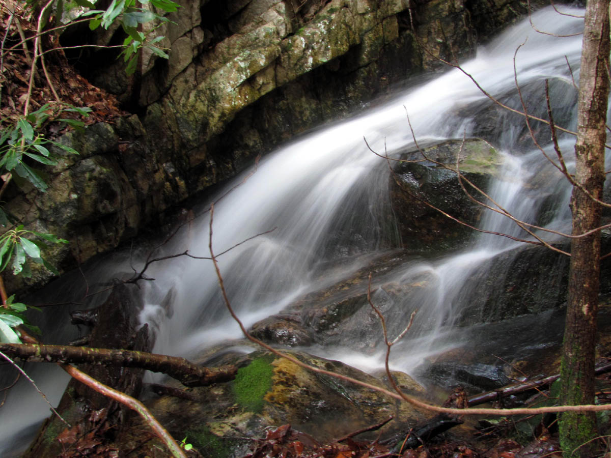
Cascades along Longarm Branch
Upper Longarm Branch Falls

Upper Longarm Branch Falls (as seen from the trail above)
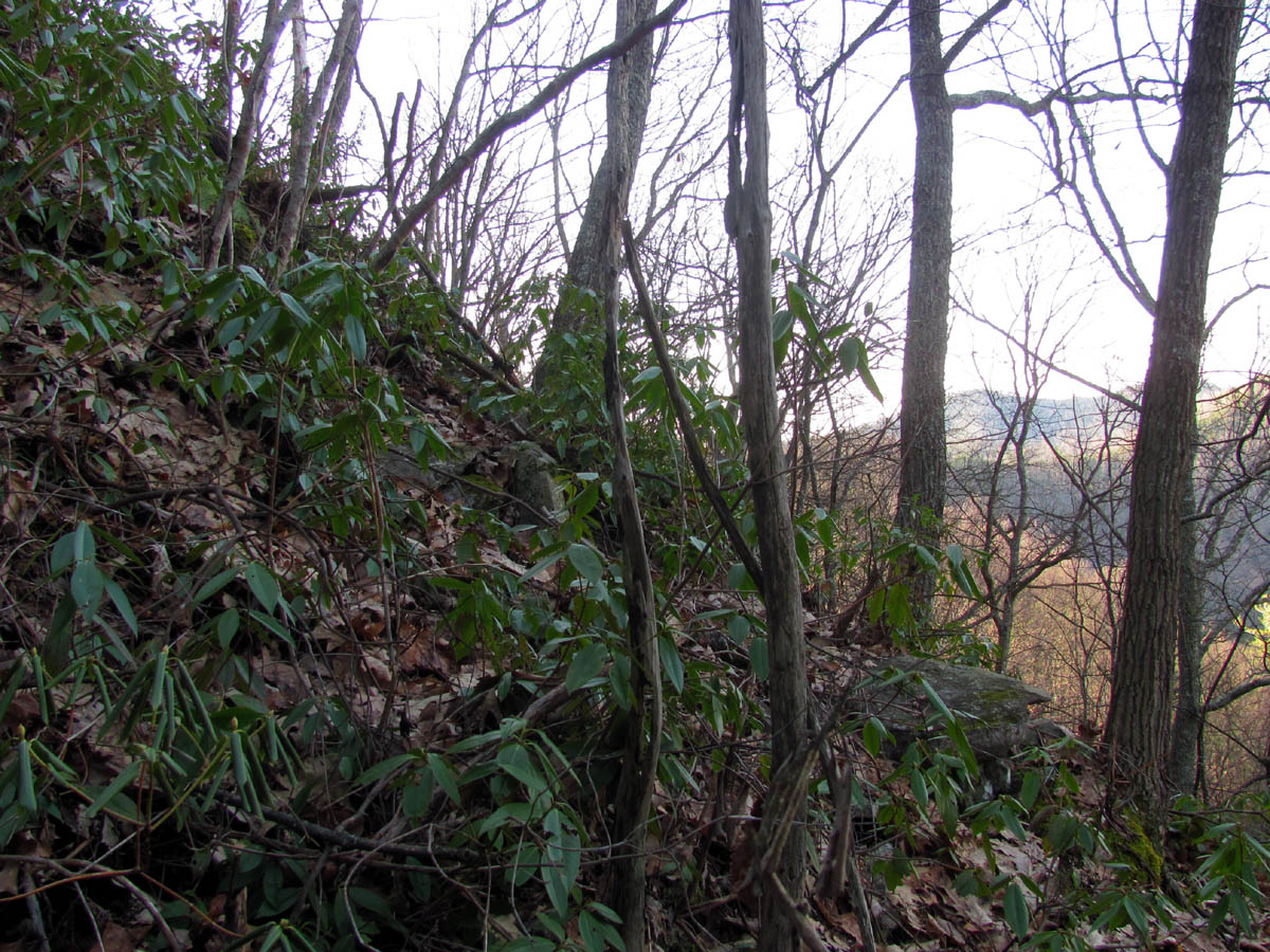
Continuing on the Longarm Branch Trail beyond the top of the Upper Longarm Branch Falls, we came across a mud hole with some frog eggs all ready to soon become tadpoles. It seems winter is ending sooner this year and signs of Spring are already showing earlier than ever before with record setting temps. At the next trail junction there was a spring bubbling right out of the ground. This is always a good sign for high water levels. Another half mile or so we came to our turn off that leads down into the Devil Fork Valley which means the uphill was finally over. Taking this turn off we made good time down to the place where we had to leave the trail and go off-trail through the laurels which would lead us to the top of the Upper Wilderness Falls.

Part of the Upper Longarm Branch Falls (that can not be seen from the bottom)

Approaching the drop off at the top of the Upper Longarm Branch Falls (find Bol'Dar)

Looking over the drop off at the top of the Upper Longarm Branch Falls
It is not far down to the falls but with no trails (old or new) and completely hidden in laurels, I can see why we, or no one else ever found these falls before. As the draw went through a short laurel hell, and narrowed down towards the edge of the dropoff where the vertical part of the falls are, I was in awe at the rock formations and different levels of the upper parts of the falls, as there is at least 80 or 100 feet of falls before it goes over the edge and at least another 60 to 75 feet or more of more vertical fall after that. This was truly an amazing waterfall and I was loving it. It is a bit steep and a dangerous place to be and is definitely not for the faint of heart. Luckily there are plenty of laurels to hold on to ! We spent quite a bit of time at the top half of the falls taking pics of the various levels (since it could not all be photographed in one shot) before making our way to the edge and then down the precarious cliff on the left side (our left) to get to the bottom.

Cascades at the top of where the Upper Wilderness Falls start

Looking down the steep slope at the first section of the Upper Wilderness Falls

Another section of the Upper Wilderness Falls as we make our way down

Another section of the Upper Wilderness Falls

Same section with some delay
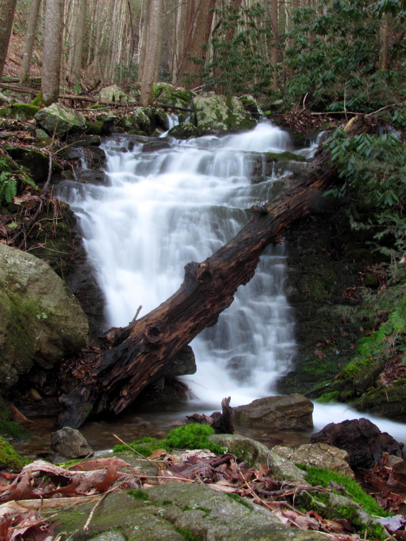
Water crashing into a huge log on its way down the upper part of the Upper Wilderness Falls

Next section below the log on the upper part of the Upper Wilderness Falls

Last section of the upper part of the Upper Wilderness Falls before it plunges over the edge and drops over the vertical part
It is very rocky and nearly vertical not to mention wet and slippery but, being very careful there is a way to get down to the bottom of these falls. I took a series of pics on my way down to try and capture the moment. We could now begin to see the lower part of the upper falls and they are stunning. Much taller than I recall seeing from the location I was at on the steep climb up the middle falls during my first trip to this area, as the trees hide most of the falls from there but, now I was up close and personal and they were huge. I tried to get a shot where you could see the entire falls and I did get some but there is just no way to see them all at one time they are so tall and the upper half is pretty much hidden when at the bottom. They are definitely well over 100 feet. I hope to bring Dave here in the near future so he can accurately measure them with his hypsometer. We hung out for awhile at the bottom but the sun was starting to set so we had to move on as the hardest obstacle was still yet to come which would be climbing down the steeper and nearly vertical middle falls.

Last part of the upper section as it drops over the edge of the vertical part of the Upper Wilderness Falls

Side view of the lower part of the Upper Wilderness Falls

Side view of the lower part of the Upper Wilderness Falls

RAT and the lower part of the Upper Wilderness Falls (Photo by Bol'Dar)

Lower part of the Upper Wilderness Falls

Lower part of Upper Wilderness Falls

Lower part of Upper Wilderness Falls
It is not very far between the two falls but there is no trail and it is rugged terrain with some of the steepest ridges on each side that I have ever seen. As I traversed along the lower edge I could look up and see the set of rocks and unreal steep ridge (from the other side this time) that I climbed up to from the bottom of the middle falls the first time I was there. All of these falls are unique and gorgeous. What makes them extra special is the fact they are hidden and inaccessible where Mother Nature can protect them from those that would otherwise trash them. It is this reason that the name ‘Wilderness Falls’ was chosen.

Looking towards the Middle Wilderness Falls from the base of the Upper Wilderness Falls

Yes it is VERY steep !!

Making our way along the steep slope toward the top of the Middle Wilderness Falls
As we made our way towards the top of the middle falls, I kept looking back at the upper falls and could see less and less of them as in a short distance the laurels and trees seemed to consume them until eventually they almost completely disappeared. It was already getting darker down in this deep hollow and as Bol’Dar made his way ahead, I could see the Longarm Ridge and Sampson Mountain glowing in the sun beyond the darkness of the ravine we were in as we neared the top of the middle falls. There was a nice set of cascades between the two falls but it was hiding in the laurels and I did not waste what little daylight we had left to go down to them. (Go go gadget zoom lens !)

View of Longarm Ridge and Sampson Mountain

View of Longarm Ridge and Sampson Mountain
As we neared the top of the falls, the slope was so steep we could barely stand on it. Knowing we did not want to be near the actual top of the falls and due to the laurel growth, we had to veer uphill slightly towards the rocky spine of the edge in order to find a way down the falls. We knew this was going to be extremely steep and risky. As we came out on the spine, it became lighter and there was some more decent visuals of the Longarm Branch Valley, the Longarm Ridge, and Sampson Mountain. Then we fell off the edge of the world. Yep, straight down. There is no other way. This is definitely an extreme descent and I can not recommend this for anyone as it is very dangerous. I would suggest coming to the middle falls from the bottom and not trying to come down them from above. We slowly and carefully made our way down, finding what places we could to get a foot hold and something to hold on to in an attempt to keep three points of contact with the earth at all times. We could soon see a glimpse of the top of the middle falls and the tall, rocky ridge looming above on the opposite side.
Approaching the spine of the ridge

Dropping off the edge of the world !

Looking back at what we had just came down
About halfway down this perpendicular hill, we found the one and only level spot to stand on where we rested our whoa-nelly gears and took some pics of the part of the falls we could see and the ridges and valleys out in the distance. This was entrancing to say the least. From there it did not get any easier but actually became more vertical. We could now begin to see some of the valley floor below the middle falls. Even though steepness can not be captured with a camera, the pics I took of looking back up from where we had just came down did indeed show it to be very steep. Now imagine it steeper and you might get an idea of how it really is.

Bol'Dar standing on the only level spot to be found

Making our way down to the bottom of the Middle Wilderness Falls

Bol"Dar descending down the Middle Wilderness Falls

Slowly getting closer to the bottom while passing through wet, vertical rocks
There are several rocky outcrops on the way down that one must maneuver around in order to reach the bottom. It was wet and very slick and still covered with leaves which made this even more difficult. One slip here and you would not stop until the bottom and it would not be a good result. We made our way down further, meticulously choosing each step and each handhold as if it could be our last (because it could be) and soon we could see almost all of the falls. The middle falls are at least 100 feet tall, maybe more and they are stunning. The light was fading fast so it was becoming hard to get any usable pictures but that did not stop me from taking them anyway.

Almost to the bottom of the Middle Wilderness Falls

RAT`s final 'slide for life Bear Grylles style' descent to the bottom of the Middle Wilderness Falls !(notice the dark slide mark!)
There was more vertical rocks near the bottom and the last part below them seemed to be straight down. Both of us ended up loosing our footing and doing a ‘slide for life’ for the last drop to the bottom of the falls. Luckily we survived with minimal injuries. Bear Grylles would have been proud. This was my third trip to the middle set of falls and this was the most amount of water I had seen on them yet which was very cool. The wind and mist coming off the falls was strong and I had to keep wiping the water off my lens to take pics. This is one of, if not my most favorite falls to be at, ever. It is an unreal place of beauty and I did not want to leave but the light was fading and we wanted to get some decent pics of the lower falls so we had to make the decision to move on.

Bol'Dar standing at the base of the Middle Wilderness Falls

Middle Wilderness Falls

Middle Wilderness Falls

Middle Wilderness Falls

Middle Wilderness Falls

Middle Wilderness Falls

Middle Wilderness Falls
The water continues falling from there over multiple drops until it reaches the largest one of the lower falls. It is unique and is just as awesome as the others only not as tall.

View of the Middle Wilderness Falls from the next drop below them.

Small falls just below the Middle Wilderness Falls

Top view of the smalls falls just below the Middle Wilderness Falls

Bol'Dar standing at the largest of the smaller falls just below the Middle Wilderness Falls

Largest of the smaller falls just below the Middle Wilderness Falls

Largest of the smaller falls just below the Middle Wilderness Falls

Largest of the smaller falls just below the Middle Wilderness Falls
Just downstream from those is what we call the Lower Wilderness Falls. These are equally as nice and about the same height. We used up the last of the fading light trying to get pics of these before hiking out the rest of the Wilderness Valley back to the Longarm Branch Trail where we still had to hike back down to the vehicle hopefully before dark.

Top of the Lower Wilderness Falls with the Middle Wilderness Falls in far background

Lower Wilderness Falls

Lower Wilderness Falls

Lower Wilderness Falls

Lower Wilderness Falls

Lower Wilderness Falls
Lower Wilderness Falls
There are a few more really nice cascades below the lower falls all the way back to the Longarm Branch Trail but that requires going down the creek which we did not have time for so we picked up the pace and took the easier way down and out the valley knowing we were not going to make it out before dark. We hiked the last mile or so out in the dark which made the last two creek crossings a bit tricky, but it was a great day to be in the woods and our adventure had been phenomenal. I can’t wait to get back here soon to show Dave the Upper Wilderness Falls.
For more photographs of these and many other waterfalls and mountains, please visit our Photo Gallery here.

 My name is 'RAT' and I love the mountains and waterfalls of the East TN. area where I live and I hope you enjoy this blog about my outdoor adventures.


One Comment to “The Wilderness Falls – 2-23-2012”